
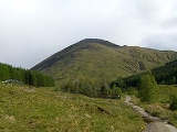
Beinn Odhar
Encyclopedia
Scotland
Scotland is a country that is part of the United Kingdom. Occupying the northern third of the island of Great Britain, it shares a border with England to the south and is bounded by the North Sea to the east, the Atlantic Ocean to the north and west, and the North Channel and Irish Sea to the...
mountain situated at the northern extremity of the Loch Lomond and the Trossachs National Park
Loch Lomond and the Trossachs National Park
Loch Lomond and The Trossachs National Park is a national park in Scotland centred on Loch Lomond, and includes several ranges of hills, the Trossachs being the most famous...
. It stands four km (2.5 mi) north of Tyndrum
Tyndrum
Tyndrum is a small village in Scotland. Its Gaelic name translates as "the house on the ridge". It lies in Strathfillan, at the southern edge of Rannoch Moor.The village is notable mainly for being at an important crossroads of transport routes...
, a location with which it has strong ties, being well seen from the village. The mountain lies on the border between Argyll and Bute
Argyll and Bute
Argyll and Bute is both one of 32 unitary council areas; and a Lieutenancy area in Scotland. The administrative centre for the council area is located in Lochgilphead.Argyll and Bute covers the second largest administrative area of any Scottish council...
and Stirling council areas within the Auch and Invermeran estate.
Overview
Beinn Odhar reaches a height of 901 metres (2956 feet) making it the 18th highest CorbettHill lists in the British Isles
The mountains and hills of Great Britain, and to a lesser extent Ireland, are the subject of a considerable number of lists that categorise them by height, topographic prominence, or other criteria. They are commonly used as a basis for peak bagging, whereby hillwalkers attempt to reach all the...
, failing to make Munro
Munro
A Munro is a mountain in Scotland with a height over . They are named after Sir Hugh Munro, 4th Baronet , who produced the first list of such hills, known as Munros Tables, in 1891. A Munro top is a summit over 3,000 ft which is not regarded as a separate mountain...
status by just 13 metres. The hill also qualifies as a Marilyn
Marilyn (hill)
A Marilyn is a mountain or hill in the United Kingdom, Republic of Ireland or Isle of Man with a relative height of at least 150 metres , regardless of absolute height or other merit...
having a considerable prominence of 457 metres making it an excellent viewpoint. The grassy, steep, conical shape of Beinn Odhar is a well-known sight for vehicles travelling on the A82 road
A82 road
The A82 is a trunk road in Scotland. It is the principal route from Lowland Scotland to the western Scottish Highlands, running from Glasgow to Inverness, going by Loch Lomond, Glen Coe and Fort William. It is the second longest primary A-road in Scotland after the A9, which is the other...
and for walkers on the West Highland Way
West Highland Way
The West Highland Way is a linear long distance footpath in Scotland, with the official status of Long Distance Route. It is 154.5km long, running from Milngavie north of Glasgow to Fort William in the Scottish Highlands, with an element of hill walking in the route...
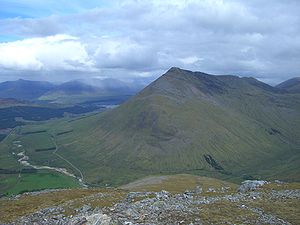
, both of which pass on the immediate western side of the mountain. Beinn Odhar stands four km south of the Munro Beinn Dorain
Beinn Dorain
Beinn Dorain , is a mountain located in the Bridge of Orchy hills of Argyll and Bute, Scotland. It is one of the most recognisable mountains in Scotland, as it curves gracefully up from the West Highland Way...
, both mountains being similar in shape and character and the possibility of confusing the two peaks by a cursory glance is not impossible.
Beinn Odhar is part of the “Auch Corbetts”, a group of five Corbetts which can be climbed in a single days walk from the hamlet of Auch (grid reference ) on the A82. This is a rare situation as the Corbetts are usually difficult to combine in any number and the opportunity to climb five in a natural round is unique. The hills name translates from the Gaelic
Scottish Gaelic language
Scottish Gaelic is a Celtic language native to Scotland. A member of the Goidelic branch of the Celtic languages, Scottish Gaelic, like Modern Irish and Manx, developed out of Middle Irish, and thus descends ultimately from Primitive Irish....
language as “Dun coloured mountain”, this alludes to the brownish-grey colour of the heather
Calluna
Calluna vulgaris is the sole species in the genus Calluna in the family Ericaceae. It is a low-growing perennial shrub growing to tall, or rarely to and taller, and is found widely in Europe and Asia Minor on acidic soils in open sunny situations and in moderate shade...
and grass on the hill. Irvine Butterfield points out that the name is a little insipid given the hills steep slopes and distinctive shape.
Geography
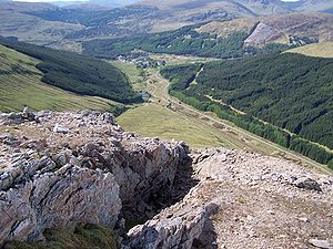
Beinn Odhar is characterised by steep slopes on all sides. The only prominent ridge of any length goes SE then south from the summit for 2.5 km to reach the subsidiary top of Meall Buidhe (653 metres) before continuing for a further three km to reach the valley floor of Strath Fillan, several km south of Tyndrum. The eastern flank of the mountain is riven by a deep gash caused by the Allt Choire Dhuibh, a stream which has it source in a small lochan on the SW side of the mountain called Lochan Choire Dhuibh which stands at a height of just under 800 metres. There is another lochan, unnamed, on the southern side of the hill at around the same height. The streams on the southern slopes form quite distinctive deep ravines (see picture) as they flow into CoireCirque
Cirque may refer to:* Cirque, a geological formation* Makhtesh, an erosional landform found in the Negev desert of Israel and Sinai of Egypt*Cirque , an album by Biosphere* Cirque Corporation, a company that makes touchpads...
Thoin, together they form the headwaters of the River Fillan.
The hills other major corrie stands on the northern slopes, this is Coire Luaidh (Corrie of Lead
Lead
Lead is a main-group element in the carbon group with the symbol Pb and atomic number 82. Lead is a soft, malleable poor metal. It is also counted as one of the heavy metals. Metallic lead has a bluish-white color after being freshly cut, but it soon tarnishes to a dull grayish color when exposed...
) which contains the hills only crags on its higher slopes. The corries name refers to lead mining which took place in the 18th and 19th centuries. Beinn Odhar stands on the Tyndrum fault, whose veins
Vein (geology)
In geology, a vein is a distinct sheetlike body of crystallized minerals within a rock. Veins form when mineral constituents carried by an aqueous solution within the rock mass are deposited through precipitation...
yielded large amounts of lead on Beinn Chùirn
Beinn Chùirn
Beinn Chùirn is a Scottish hill situated five kilometres west-southwest of Tyndrum, it stands on the border of Stirlingshire and Perthshire at the northern extremity of the Loch Lomond and the Trossachs National Park.- Overview :...
to the SW, however the mines on Odhar were not as productive. The best example of former mining activity on the hill can be seen on the southern slopes, at a height of 650 metres there is considerable evidence of an adit
Adit
An adit is an entrance to an underground mine which is horizontal or nearly horizontal, by which the mine can be entered, drained of water, and ventilated.-Construction:...
going into the hillside and much mining waste. Beinn Odhar stands on the drainage divide of Scotland with rainfall from the mountain going to both coasts, either going west via Glen Orchy
Glen Orchy
Glen Orchy is a long glen in Argyll and Bute in Scotland. It runs south-westerly from the Bridge of Orchy to Inverlochy following the River Orchy...
to reach the sea at Oban
Oban
Oban Oban Oban ( is a resort town within the Argyll and Bute council area of Scotland. It has a total resident population of 8,120. Despite its small size, it is the largest town between Helensburgh and Fort William and during the tourist season the town can be crowded by up to 25,000 people. Oban...
or east by the River Tay
River Tay
The River Tay is the longest river in Scotland and the seventh-longest in the United Kingdom. The Tay originates in western Scotland on the slopes of Ben Lui , then flows easterly across the Highlands, through Loch Dochhart, Loch Lubhair and Loch Tay, then continues east through Strathtay , in...
to reach the sea at Dundee
Dundee
Dundee is the fourth-largest city in Scotland and the 39th most populous settlement in the United Kingdom. It lies within the eastern central Lowlands on the north bank of the Firth of Tay, which feeds into the North Sea...
.
Ascents and view
Beinn Odhar is usually climbed from the south and there are three popular starting points. The start from the village of Tyndrum goes north via a track which was formerly the main road until the 1930s but now carries the West Highland Way. After two km the track is left and the hill is ascended by the southern slopes passing the old mine and the unnamed lochan on the way. Guide books mention a track as far as the mine on this route but this is not easy to locate. Another starting point is Dalrigh on the A82 (grid reference ), this route climbs by the long south ridge passing over Meall Buidhe and is a longer and less steep alternative.Walkers who wish to tackle all five of the Auch Corbetts, a tough day with over 2000 metres of ascent, are advised by guide books to start at a parking place on the A82 at grid reference as parking at Auch is limited. From here it is possible to climb Beinn Odhar by the south ridge. The top of the mountain is marked by a cairn and give fine views to the Black Mount to the north and the hills around Crianlarich
Crianlarich
Crianlarich is a village in the Stirling district and registration county of Perthshire, Scotland, about six miles north-east of the head of Loch Lomond...
to the south.