

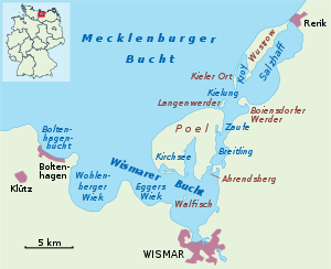
Bay of Wismar
Encyclopedia
Headlands and bays
Headlands and bays are two related features of the coastal environment.- Geology and geography :Headlands and bays are often found on the same coastline. A bay is surrounded by land on three sides, whereas a headland is surrounded by water on three sides. Headlands are characterized by high,...
in the southwestern Baltic Sea
Baltic Sea
The Baltic Sea is a brackish mediterranean sea located in Northern Europe, from 53°N to 66°N latitude and from 20°E to 26°E longitude. It is bounded by the Scandinavian Peninsula, the mainland of Europe, and the Danish islands. It drains into the Kattegat by way of the Øresund, the Great Belt and...
, in Germanys' Mecklenburg-Vorpommern, and is considered the south-central part of the much larger arm of the Baltic known as the Mecklenburg Bay
Bay of Mecklenburg
The Bay of Mecklenburg , also known as the Mecklenburg Bay or Mecklenburg Bight, is a long narrow basin making up the southwestern finger-like arm of the Baltic Sea, between the shores of Germany to the south and the Danish islands of Lolland, Falster, and Møn to the north, the shores of Jutland to...
(or Mecklenburg Bight
Bight (geography)
In geography, bight has two meanings. A bight can be simply a bend or curve in any geographical feature—usually a bend or curve in the line between land and water....
, for its long narrow bent shape)— a long fingerlike gulf oriented to the west-southwest (WSW) from the (central) Baltic proper. Wismar bay is considered one of the finest natural harbors on the Baltic, and served as the destination for much seaborne shipping until circa the 1910s when its minimum depths of 5 metres (16.4 ft) became too shallow for larger more modern ships. Today, because of the shallow sheltered waters the bay is the subject of much research via underwater archeology
There are four lobe like parts of the Bay of Wismar which are themselves bays on its southern shores, each separated by a north intruding headland
Headlands and bays
Headlands and bays are two related features of the coastal environment.- Geology and geography :Headlands and bays are often found on the same coastline. A bay is surrounded by land on three sides, whereas a headland is surrounded by water on three sides. Headlands are characterized by high,...
from the others (see maps at right) and a broad channel
Channel (geography)
In physical geography, a channel is the physical confine of a river, slough or ocean strait consisting of a bed and banks.A channel is also the natural or human-made deeper course through a reef, sand bar, bay, or any shallow body of water...
running northwest to southeast parallel to the line formed by the tips of the four bounding headlands. The tips of the four headlands are remarkably well aligned and very closely co-linear spanning 10.8 mi (17.4 km) northwest to southeast tip to tip along the channel along which the inlets are respectively Boltenhagen Bay, Wohlenberger Wiek, Eggers Wiek, and the inner bay. A channel, the Breitling between Poel island and the mainland is accounted part of the bay as well, which in its northern limit is the north shore of the island.
From the western headland to the eastern shore of the inner bay is 13.4 miles (21.6 km). All of the waters are bounded by Poel Island on one side—a large mainly agricultural and recreational island sheltering the most easterly parts of bay (the inner Bay of Wismar and the small coastal seaport) along most of its northern edge.
The sheltered anchorage extends over an rhombus
Rhombus
In Euclidean geometry, a rhombus or rhomb is a convex quadrilateral whose four sides all have the same length. The rhombus is often called a diamond, after the diamonds suit in playing cards, or a lozenge, though the latter sometimes refers specifically to a rhombus with a 45° angle.Every...
shaped area in the southerly lee of Poel island roughly 3 miles (4.8 km) N-S in the inner anchorage narrowing to 1.75 miles (2.8 km) N-S between the innermost headland and southernmost tip of the island and roughly 5–6 miles (8–10 km) that distance WNW to ESE.
In general, the main waters of the bay are located to the west, southwest and south relative to Poel Island which is wholly within Wismar Bay. The northern tip of the island in a line westerly to the headland of Großklützhöved (3.35 mi (5.4 km) north of the village of Klütz
Klütz
Klütz is a town in the Nordwestmecklenburg district, in Mecklenburg-Western Pomerania, Germany. It is situated near the Baltic Sea coast, 22 km northwest of Wismar, and 33 km northeast of Lübeck.-External links:...
) forms the mouth of the bay.
Main ports: Wismar
Wismar
Wismar , is a small port and Hanseatic League town in northern Germany on the Baltic Sea, in the state of Mecklenburg-Vorpommern,about 45 km due east of Lübeck, and 30 km due north of Schwerin. Its natural harbour, located in the Bay of Wismar is well-protected by a promontory. The...
, 20 mi (32.2 km) by rail north of Schwerin
Schwerin
Schwerin is the capital and second-largest city of the northern German state of Mecklenburg-Vorpommern. The population, as of end of 2009, was 95,041.-History:...
.