

Bars county
Encyclopedia
Bars is the name of a historic administrative county (comitatus
) of the Kingdom of Hungary
. Its territory is presently in central and southern Slovakia
. Today in Slovakia, Tekov
is the informal designation of the corresponding territory.
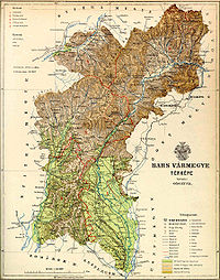 Bars County shared borders with the Hungarian counties (Slovak: ), Slovak: ), (Slovak: ), , (Slovak: ) and (Slovak: ). It was situated along the Hron
river between Hont in the east, Kremnica
(Hungarian: and Hronská Dúbrava
in the north (which were part of the county), the Žitava
river in the west, and Bešeňov
and Bíňa
in the south (which was not part of the county). The rivers Hron and Žitava ran through the county. The county was characterised by mining. Around 1910, its area was 2724 km² (1,051.7 sq mi).
Castle, then from the late 16th century Topoľčianky
and since the late 18th century Zlaté Moravce
.
between 1663 and 1685 and managed as Uyvar
eyalet by her. In the aftermath of World War I, the area became part of newly formed Czechoslovakia
, as recognized by the concerned states in the 1920 Treaty of Trianon
.
Following the provisions of the controversial First Vienna Award
, the southern part of the area came under Hungarian control in November 1938. This was merged with the southern part of former Hont
county to form Bars-Hont county, with capital Levice
(Hungarian: Léva).
After World War II, the Trianon borders were restored and the area was completely in Czechoslovakia
again. In 1993, Czechoslovakia
was split and Tekov became part of Slovakia
.
Comitatus (Kingdom of Hungary)
A county is the name of a type of administrative units in the Kingdom of Hungary and in Hungary from the 10th century until the present day....
) of the Kingdom of Hungary
Kingdom of Hungary
The Kingdom of Hungary comprised present-day Hungary, Slovakia and Croatia , Transylvania , Carpatho Ruthenia , Vojvodina , Burgenland , and other smaller territories surrounding present-day Hungary's borders...
. Its territory is presently in central and southern Slovakia
Slovakia
The Slovak Republic is a landlocked state in Central Europe. It has a population of over five million and an area of about . Slovakia is bordered by the Czech Republic and Austria to the west, Poland to the north, Ukraine to the east and Hungary to the south...
. Today in Slovakia, Tekov
Tekov
Tekov [Hungarian: Bars] is the traditional name of a region situated in southern and central Slovakia. Its territory encompasses the former Bars county, existing in the Kingdom of Hungary from the 11th century until 1918, though it is now administratively divided between the Nitra and Banská...
is the informal designation of the corresponding territory.
Geography
Hron
Hron is a 298 km long left tributary of the Danube and the second longest river in Slovakia. It flows from its source located in the Low Tatra mountains through central and southern Slovakia, pouring into the Danube near Štúrovo and Esztergom...
river between Hont in the east, Kremnica
Kremnica
Kremnica is a town in central Slovakia. It has some 5,700 inhabitants. The well-preserved medieval town built above important gold mines is the site of the oldest still-working mint in the world.-History:...
(Hungarian: and Hronská Dúbrava
Hronská Dúbrava
Hronská Dúbrava is a village and municipality in Žiar nad Hronom District in the Banská Bystrica Region of central Slovakia....
in the north (which were part of the county), the Žitava
Žitava
Žitava may refer to:*Žitava , a river in Slovakia*a part of the municipality Radvaň nad Dunajom*Zittau, Žitava being the Slavic name of the town in Germany-See also:...
river in the west, and Bešeňov
Bešenov
Bešeňov is a municipality and village in the Nové Zámky District in the Nitra Region of south-west Slovakia.-Geography:The village lies at an altitude of 121 metres and covers an area of 17.096 km². It has a population of about 1726 people.-Facilities:...
and Bíňa
Bína
Bíňa is a municipality and village in the Nové Zámky District in the Nitra Region of south-west Slovakia.-History:In historical records the village was first mentioned in 1135 written as Byn. Earlier the Romans built a fortress here and in 173 emperor Marcus Aurelius wrote his famous diary in this...
in the south (which was not part of the county). The rivers Hron and Žitava ran through the county. The county was characterised by mining. Around 1910, its area was 2724 km² (1,051.7 sq mi).
Capitals
The capital of the county was the Tekov Castle, then LeviceLevice
Levice is a town in western Slovakia. The town lies on the left bank of the lower Hron river. The Old Slavic name of the town was Leva, which means "the Left One"....
Castle, then from the late 16th century Topoľčianky
Topolcianky
Topoľčianky is a village and municipality in Zlaté Moravce District of the Nitra Region, in western-central Slovakia.-Tourisme:Topol´čienky is unique for its European Bison Reserve. By the 1930s only a handful of wisents remained, in Poland...
and since the late 18th century Zlaté Moravce
Zlaté Moravce
Zlaté Moravce is a town in south-western Slovakia.-Basic data:It is the capital and the biggest town of Zlaté Moravce District. It is approximately 120 km from the Slovak capital Bratislava and 32 km from Nitra.-History:...
.
History
The county arose in the 11th century. The southern part of this county was occupied by Ottoman EmpireOttoman Empire
The Ottoman EmpireIt was usually referred to as the "Ottoman Empire", the "Turkish Empire", the "Ottoman Caliphate" or more commonly "Turkey" by its contemporaries...
between 1663 and 1685 and managed as Uyvar
Nové Zámky
Nové Zámky is a town in southwestern Slovakia.-Geography:The town is located on the Danubian Lowland, on the Nitra River, at an altitude of 119 metres. It is located around 100 km from Bratislava and around 25 km from the Hungarian border. It is a road and railway hub of southern...
eyalet by her. In the aftermath of World War I, the area became part of newly formed Czechoslovakia
Czechoslovakia
Czechoslovakia or Czecho-Slovakia was a sovereign state in Central Europe which existed from October 1918, when it declared its independence from the Austro-Hungarian Empire, until 1992...
, as recognized by the concerned states in the 1920 Treaty of Trianon
Treaty of Trianon
The Treaty of Trianon was the peace agreement signed in 1920, at the end of World War I, between the Allies of World War I and Hungary . The treaty greatly redefined and reduced Hungary's borders. From its borders before World War I, it lost 72% of its territory, which was reduced from to...
.
Following the provisions of the controversial First Vienna Award
First Vienna Award
The First Vienna Award was the result of the First Vienna Arbitration, which took place at Vienna's Belvedere Palace on November 2, 1938. The Arbitration and Award were direct consequences of the Munich Agreement...
, the southern part of the area came under Hungarian control in November 1938. This was merged with the southern part of former Hont
Hont
Hont is the name of a historic administrative county of the Kingdom of Hungary and then shortly of Czechoslovakia...
county to form Bars-Hont county, with capital Levice
Levice
Levice is a town in western Slovakia. The town lies on the left bank of the lower Hron river. The Old Slavic name of the town was Leva, which means "the Left One"....
(Hungarian: Léva).
After World War II, the Trianon borders were restored and the area was completely in Czechoslovakia
Czechoslovakia
Czechoslovakia or Czecho-Slovakia was a sovereign state in Central Europe which existed from October 1918, when it declared its independence from the Austro-Hungarian Empire, until 1992...
again. In 1993, Czechoslovakia
Czechoslovakia
Czechoslovakia or Czecho-Slovakia was a sovereign state in Central Europe which existed from October 1918, when it declared its independence from the Austro-Hungarian Empire, until 1992...
was split and Tekov became part of Slovakia
Slovakia
The Slovak Republic is a landlocked state in Central Europe. It has a population of over five million and an area of about . Slovakia is bordered by the Czech Republic and Austria to the west, Poland to the north, Ukraine to the east and Hungary to the south...
.
Demographics
Population by language (1910 manipulated census by the ruling Hungarian bureaucracy):- Slovak = 97,824
- Hungarian = 62,022
- German = 17,366
Subdivisions
In the early 20th century, the subdivisions of Bars/Tekov county were:| Districts (járás) | |
|---|---|
| District | Capital |
| Aranyosmarót | Aranyosmarót, SK Slovak language Slovak , is an Indo-European language that belongs to the West Slavic languages .Slovak is the official language of Slovakia, where it is spoken by 5 million people... Zlaté Moravce Zlaté Moravce Zlaté Moravce is a town in south-western Slovakia.-Basic data:It is the capital and the biggest town of Zlaté Moravce District. It is approximately 120 km from the Slovak capital Bratislava and 32 km from Nitra.-History:... |
| Garamszentkereszt | Garamszentkereszt, SK Žiar nad Hronom Žiar nad Hronom Žiar nad Hronom is a town in Banská Bystrica Region, Slovakia.-Geography:It is located in the Žiar Basin, on the Hron river, around 40 km from Banská Bystrica and 170 km from Bratislava... |
| Léva | Léva, SK Levice Levice Levice is a town in western Slovakia. The town lies on the left bank of the lower Hron river. The Old Slavic name of the town was Leva, which means "the Left One".... |
| Oszlány | Oszlány, SK Oslany Oslany Oslany is a village and municipality in Prievidza District in the Trenčín Region of western Slovakia.-Geography:The municipality lies at an altitude of 234 metres and covers an area of 25.153 km². It has a population of about 2224 people.... |
| Verebély | Verebély, SK Vráble Vráble Vráble is a small town in the Nitra District, Nitra Region, western Slovakia.-Geography:It is located in the Danubian Hills on the Žitava river, about 20 km south-east-east from Nitra. The cadastral area of the town has an altitude from 140 to 240 m ASL... |
| Urban districts (rendezett tanácsú város) | |
| Körmöcbánya, SK Kremnica Kremnica Kremnica is a town in central Slovakia. It has some 5,700 inhabitants. The well-preserved medieval town built above important gold mines is the site of the oldest still-working mint in the world.-History:... |
|
| Léva, SK Levice Levice Levice is a town in western Slovakia. The town lies on the left bank of the lower Hron river. The Old Slavic name of the town was Leva, which means "the Left One".... |
|
| Újbánya, SK Nová Baňa Nová Bana Nová Baňa is a small town in the west of central Slovakia and the largest town of the Žarnovica District, located in the Banská Bystrica Region.- Geography :... |
|