

Barnard Point
Encyclopedia
Headland
A headland is a point of land, usually high and often with a sheer drop, that extends out into a body of water.Headland can also refer to:*Headlands and bays*headLand, an Australian television series...
which marks the southeast side of the entrance to False Bay
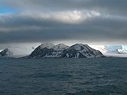
False Bay, Livingston Island
False Bay is a 4 mi long bay, which lies between Barnard Point and Miers Bluff on the south side of Livingston Island, in the South Shetland Islands, Antarctica. It was probably first entered and charted by Capt...
on the south side of Livingston Island in the South Shetland Islands
South Shetland Islands
The South Shetland Islands are a group of Antarctic islands, lying about north of the Antarctic Peninsula, with a total area of . By the Antarctic Treaty of 1959, the Islands' sovereignty is neither recognized nor disputed by the signatories and they are free for use by any signatory for...
, Antarctica. This point was known to sealers
Seal hunting
Seal hunting, or sealing, is the personal or commercial hunting of seals. The hunt is currently practiced in five countries: Canada, where most of the world's seal hunting takes place, Namibia, the Danish region of Greenland, Norway and Russia...
as early as 1822. The name was applied about a century later, probably after Mount Barnard (now Mount Friesland
Mount Friesland
Mount Friesland is the summit of Tangra Mountains on Livingston Island, in the South Shetland Islands, Antarctica. The peak is rising to 1700 m sharp, and is heavily glaciated and crevassed. Situated 12.5 km northeast of Barnard Point, 9.7 km east-southeast of St...
) which surmounts it to the northeast. Charles H. Barnard, captain of the ship Charity of New York, was a sealer in the South Shetland Islands in 1820–21.
Location
The point is located at (62°45′29"S 60°20′19"W) which is 1.5 kilometre (0.93205910497471 mi) north-northwest of Botev PointBotev Point
Botev Point is the south extremity of both Rozhen Peninsula and Livingston Island in the South Shetland Islands, Antarctica formed by an offshoot of Botev Peak in the Veleka Ridge of Tangra Mountains....
and 6.6 kilometres (4 mi) southeast of Miers Bluff
Miers Bluff
Miers Bluff is the point forming the southwest extremity of Hurd Peninsula, the southeast side of the entrance to South Bay and the northwest side of the entrance to False Bay in the South Shetland Islands, Antarctica....
(British mapping in 1968, and Bulgarian in 2005 and 2009).
Maps
- L.L. Ivanov et al. Antarctica: Livingston Island and Greenwich Island, South Shetland Islands. Scale 1:100000 topographic map. Sofia: Antarctic Place-names Commission of Bulgaria, 2005.
- L.L. Ivanov. Antarctica: Livingston Island and Greenwich, Robert, Snow and Smith Islands. Scale 1:120000 topographic map. Troyan: Manfred Wörner Foundation, 2009. ISBN 978-954-92032-6-4