Barlavento
Encyclopedia

Cape Verde
The Republic of Cape Verde is an island country, spanning an archipelago of 10 islands located in the central Atlantic Ocean, 570 kilometres off the coast of Western Africa...
archipelago
Archipelago
An archipelago , sometimes called an island group, is a chain or cluster of islands. The word archipelago is derived from the Greek ἄρχι- – arkhi- and πέλαγος – pélagos through the Italian arcipelago...
.
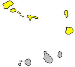
It can be divided in to two groups: Santo Antão, São Vicente
São Vicente, Cape Verde
São Vicente , also Son Visent or Son Sent in Cape Verdean Creole, is one of the Barlavento islands of Cape Verde. It is located between the islands of Santo Antão and Santa Luzia, with the Canal de São Vicente separating it from Santo Antão.- Geography :The island is roughly rectangular in shape...
, São Nicolau, Santa Luzia
Santa Luzia, Cape Verde
Santa Luzia is an island of the Barlavento archipelago in Cape Verde located between São Nicolau and São Vicente. The area is 35 km² . The highest point is Monte Grande elevating 395 m...
islands and Branco and Raso islets lie to the west and are rocky, volcanic, agricultural islands.
Sal
Sal, Cape Verde
Sal is an island in Cape Verde. It belongs to the northern group of islands, called Barlavento. The island is composed by a single administrative division, the Sal municipality. The island is home to Amílcar Cabral International Airport, the main airport of Cape Verde.- Geography :The island is...
and Boa Vista
Boa Vista, Cape Verde
Boa Vista is the easternmost island of Cape Verde. It is located in the Barlavento group of the archipelago. The island is known for marine turtles and traditional music, as well as its ultramarathon and its sand dunes and beaches...
lie to the east and are flat, desert
Desert
A desert is a landscape or region that receives an extremely low amount of precipitation, less than enough to support growth of most plants. Most deserts have an average annual precipitation of less than...
islands with economies once based on salt
Salt
In chemistry, salts are ionic compounds that result from the neutralization reaction of an acid and a base. They are composed of cations and anions so that the product is electrically neutral...
and now turning to tourism
Tourism
Tourism is travel for recreational, leisure or business purposes. The World Tourism Organization defines tourists as people "traveling to and staying in places outside their usual environment for not more than one consecutive year for leisure, business and other purposes".Tourism has become a...
, having more in common with Maio
Maio, Cape Verde
Maio is the easternmost of the Sotavento islands of Cape Verde. Maio is located south of the islands of Boa Vista and east of Santiago. The island is also known for its large forest, which is unusual for Cape Verde.-Geography:The island covers an area of 269 km²...
among the Sotavento.
Minor islets include Ilhéu de Sal-Rei
Ilhéu de Sal-Rei
Ilhéu de Sal Rei is an islet located 1 km west of Sal Rei and nearly 1 km southwest of its nearest point of Boa Vista Island in Cape Verde. They are administratively a part of the municipality of Boa Vista...
and Ilhéu do Baluarte (or Ilhéu do Roque) off Boa Vista, Ilhéu dos Pássaros
Ilhéu dos Pássaros
Ilhéu de Pássaros is an islet located between 2 to 3 kilometres NW of the island of São Vicente and also 2 kilometres northwest of the Mindelo's nearby point, the João Ribeira. They are administratively a part of the municipality of São Vicente...
off São Vicente and Ilhéu Rabo de Junco
Ilhéu Rabo de Junco
Ilhéu Rabo de Junco is an islet located nearly 500 metres west of the nearest point of the island of Sal. They are administratively a part of the municipality of Sal Rei. The islet is a volcanic seamount and was once connected with the rest of the island.-Geography:The islet contains mainly no...
off Sal.

