

Ilhéu dos Pássaros
Encyclopedia
| Ilhéu dos Pássaros Djeu |
|
|---|---|
| Area: | approximately 0.04 km² |
| Population: | Uninhabited |
| Elevation Elevation The elevation of a geographic location is its height above a fixed reference point, most commonly a reference geoid, a mathematical model of the Earth's sea level as an equipotential gravitational surface .... : |
40 m |
| Length: | approximately 150 m |
| Width: | approximately 150 m |
| Location: | Cape Verde Cape Verde The Republic of Cape Verde is an island country, spanning an archipelago of 10 islands located in the central Atlantic Ocean, 570 kilometres off the coast of Western Africa... , nearly 2 km northwest of the island of São Vicente São Vicente, Cape Verde São Vicente , also Son Visent or Son Sent in Cape Verdean Creole, is one of the Barlavento islands of Cape Verde. It is located between the islands of Santo Antão and Santa Luzia, with the Canal de São Vicente separating it from Santo Antão.- Geography :The island is roughly rectangular in shape... |
| Range Mountain range A mountain range is a single, large mass consisting of a succession of mountains or narrowly spaced mountain ridges, with or without peaks, closely related in position, direction, formation, and age; a component part of a mountain system or of a mountain chain... : |
none |
| Type: | stratovolcano |
Ilhéu de Pássaros (in Cape Verdean Creole: Djeu) is an islet located between 2 to 3 kilometres NW of the island of São Vicente
São Vicente, Cape Verde
São Vicente , also Son Visent or Son Sent in Cape Verdean Creole, is one of the Barlavento islands of Cape Verde. It is located between the islands of Santo Antão and Santa Luzia, with the Canal de São Vicente separating it from Santo Antão.- Geography :The island is roughly rectangular in shape...
(Mindelo
Mindelo
For the parish in Portugal, see Mindelo, PortugalMindelo , is a port city in the northern part of the island of São Vicente in Cape Verde. Mindelo is also the seat of the parish of Nossa Senhora da Luz, and this island's municipality...
) and also 2 kilometres northwest of the Mindelo's nearby point, the João Ribeira. They are administratively a part of the municipality of São Vicente. The islet is a volcanic seamount.
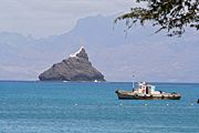
Geography
The islet contains dry grasslands and rock ledges that elevate up to 40 m. Its length and width is around 150 metres. It forms the boundary with the Mindelo BayMindelo Bay
Mindelo Bay is a bay located northwest of the island of São Vicente. The ferry route linking with the port of Porto Novo on Santo Antão and Mindelo on São Vicente crosses the canal with the boat named Mar d' Canal as well as shipping lines with Mindelo and other places around the world including...
and the Canal de São Vicente
Canal de São Vicente
The Canal de São Vicente is a channel separating the islands of Santo Antão and São Vicente. Its length is around 10 to 20 km and the width is approximately 15 km. The second closest distance with another island, the first being with Santa Luzia...
and is in the Atlantic Ocean
Atlantic Ocean
The Atlantic Ocean is the second-largest of the world's oceanic divisions. With a total area of about , it covers approximately 20% of the Earth's surface and about 26% of its water surface area...
.
Panorama
The islet can definitely be seen from the southern part of the island of Santo Antão and the western and the northern half of the island of São Vicente excluding the southern, the southeastern and the eastern parts especially form Monte VerdeMonte Verde, Cape Verde
Monte Verde is the tallest mountain in the island of São Vicente, Cape Verde. The mountain is located east of the city of Mindelo, the island's main city...
, Lazareto, Monte Cara and around the bay and the city of Mindelo. The islet also features a lighthouse. The islet has been photographed online including http://www.mindelo.info, bluediscovery.com and ecaboverde.com, see External links with more info.
Nearest islands and islets
- Santo Antão, north
- São VicenteSão Vicente, Cape VerdeSão Vicente , also Son Visent or Son Sent in Cape Verdean Creole, is one of the Barlavento islands of Cape Verde. It is located between the islands of Santo Antão and Santa Luzia, with the Canal de São Vicente separating it from Santo Antão.- Geography :The island is roughly rectangular in shape...
, east, south and west
External links
- Ilhéu dos Pássaros on ecaboverde.com - Retrieved or added in 2005
- Map and aerial photos:
- Street map information from: Mapquest, Windows LiveLocal or Google or Yahoo! Maps
- Satellite images: Google or Microsoft Virtual Earth - image now available