

Barangay Santa Clara, Santa Maria, Bulacan
Encyclopedia
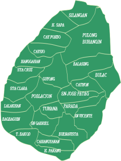
Santa Clara is one of the twenty-four barangay
Barangay
A barangay is the smallest administrative division in the Philippines and is the native Filipino term for a village, district or ward...
s comprising the municipality of Santa Maria, Bulacan
Santa Maria, Bulacan
According to the 2007 Census, the population of Sta. Maria grew by 60,976 from 144,282 in 2000 to 205,258 in 2007, making it the third biggest LGU in Bulacan in terms of population. The municipality has a population density of 2,257.56 persons per km² in 24 barangays.Total income in Santa Maria was...
, in the Philippines
Philippines
The Philippines , officially known as the Republic of the Philippines , is a country in Southeast Asia in the western Pacific Ocean. To its north across the Luzon Strait lies Taiwan. West across the South China Sea sits Vietnam...
. It is bordered by Barangay Lalakhan on the south-west, Bagbaguin on the south, Poblacion on the east, Sta. Cruz on the north and Barangay Tambubong in Bocaue on the west.
Area and Location
Santa Maria, Bulacan
According to the 2007 Census, the population of Sta. Maria grew by 60,976 from 144,282 in 2000 to 205,258 in 2007, making it the third biggest LGU in Bulacan in terms of population. The municipality has a population density of 2,257.56 persons per km² in 24 barangays.Total income in Santa Maria was...
with a land area of 214.70 hectares or 2.1470 km2, slightly smaller than the barangay of Poblacion.
Sta. Clara is located on the south-west portion of Sta. Maria and thirty-three kilometers north from Manila
Manila
Manila is the capital of the Philippines. It is one of the sixteen cities forming Metro Manila.Manila is located on the eastern shores of Manila Bay and is bordered by Navotas and Caloocan to the north, Quezon City to the northeast, San Juan and Mandaluyong to the east, Makati on the southeast,...
.
Climate
The prevailing climatic conditions in the barangay are categorized into two (2) types: dry and wet season.The annual mean temperature in the area is 27℃. The warmest month is May with a mean temperature of 29.9℃ while the coldest is January at 25.2℃.
The mean annual relative humidity in the Barangay is 77% which is not high. The mean monthly relative humidity is lowest in March at 64% and highest in September at 84%
Demographics
As of 2007 census, Sta. Clara has a population of 10,052 people with a density of 4,682 person per km2. The projected population of the barangay by 2010 is 11,080 with a growth rate of 3.3%Population Projection
This is the projected population of the barangay by the next few years:- 2008 - 10,384
- 2009 - 10,726
- 2010 - 11,080
- 2011 - 11,446
- 2012 - 11,824
- 2013 - 12,214
- 2014 - 12,617
- 2015 - 13,033
- 2020 - 15,330
- 2030 - 21,210
Note: This is only a prediction.
Transportation
Main Roads
- Narra St./J.P Rizal St.
- Sta. Clara By-Pass Road
- Tindalo St.
- Yakal St./Luwasan