
Balloon satellite
Encyclopedia
A balloon satellite is a satellite
that is inflated with gas
after it has been put into orbit
.
abbreviations:
on August 12, 1960 by the United States. It originally had a spherical shape measuring 30 metres (98.4 ft), with a thin metal-coated plastic shell made of Mylar. It served for testing as a "passive" communication and geodetic
satellite. Its international COSPAR
number was 6000901 (9th satellite launched in 1960, 1st component).
One of the first radio contacts using the satellite was successful at a distance of nearly 80000 kilometres (49,709.8 mi) (between the east coast of the US and California). By the time Echo 1 burned up in 1968, the measurements of its orbit by several dozen earth stations had improved our knowledge of the precise shape of the planet by nearly a factor of ten.
Its successor was the similarly built Echo 2
(1964 to about 1970). This satellite circled the Earth about 400 kilometres (248.5 mi) lower, not at an angle of 47° like that of Echo 1, but in a polar orbit with an average angle of 81°. This enabled radio contact and measurements to be made at higher latitudes. Taking part in the Echo orbit checks to analyze disturbances in its orbit and in the Earth's gravitational field were thirty to fifty professional earth stations, as well as around two hundred amateur astronomer
s across the planet in "Moonwatch" stations; these contributed around half of all sightings.
allows us to calculate easily how far a satellite is visible at such a great height. It can be determined that a satellite in a 1500 kilometres (932.1 mi) orbit rises and sets when the horizontal distance is 4600 kilometres (2,858.3 mi). However, the atmosphere causes this figure to vary slightly. Thus if two radio stations are 9000 kilometres (5,592.4 mi) apart and the satellite's orbit goes between them, they may be able to receive each other's reflected radio signals if the signals are strong enough.
Optical visibility is, however, lower than that of radio waves, because
Despite this there is no problem observing a flying body such as Echo 1 for precise purposes of satellite geodesy, down to a 20° elevation, which corresponds to a distance of 2900 kilometres (1,802 mi). In theory this means that distances of up to 5000 kilometres (3,106.9 mi) between measuring points can be "bridged", and in practice this can be accomplished at up to 3000 –.
For visual and photographic observation of bright satellites and balloons, and regarding their geodetic use, see Echo 1 and Pageos
for further information.
series were constructed as balloons (possibly Explorer 19 and 38).
Echo 1 was an acknowledged success of radio engineering, but the passive principle of telecommunications (reflection of radio waves on the balloon's surface) was soon replaced by active systems. Telstar 1 (1962) and Early Bird
(1965) were able to transmit several hundred audio channels simultaneously in addition to a television program exchanged between continents.
Satellite geodesy with Echo 1 and 2 was able to fulfill all expectations not only for the planned 2–3 years, but for nearly 10 years. For this reason NASA
soon planned the launch of the even larger 40 metres (131.2 ft) balloon Pageos
. The name is from "passive geodesic satellite", and sounds similar to "Geos", a successful active electronic satellite from 1965.
 Pageos
was specially launched for the "global network of satellite geodesy
", which occupied about 20 full-time observing teams all over the world until 1973. All together they recorded 3000 usable photographic plates from 46 tracking stations with calibrated all-electronic BC-4 cameras (1:3 / focal length 30 centimetre). From these images they were able to calculate the stations' position three-dimensionally with a precision of about 4 metres (13.1 ft). The coordinator of this project was Professor H. H. Schmid, from the ETH Zurich
.
Three stations of the global network were situated in Europe: Catania in Sicily
, Hohenpeißenberg in Bavaria
and Tromsø
in northern Norway
. For the completion of the navigational network exact distance measurements were needed; these were taken on four continents and across Europe with a precision of 0.5 millimetre (0.0196850393700787 in) per kilometer.
The global network enabled the calculation of a "geodetic date" (the geocentric position of the measurement system) on different continents, within a few meters. By the early 1970s reliable values for nearly 100 coefficients of the Earth's gravity field could be calculated.
Since satellites circle the earth at about 7 –, a time error of 0.002 second translates into a deviation of about 15 metres (49.2 ft). In order to meet a new goal of measuring the tracking stations precisely within a couple of years, a method of flashing light beacons was adopted around 1960.
To build a three-dimensional measuring network, geodesy needs exactly defined target points, more so than a precise time. This precision is easily reached by having two tracking stations record the same series of flashes from one satellite.
Flash technology was already mature in 1965 when the small electronic satellite Geos (later named Geos 1) was launched; along with its companion Geos 2, it brought about a remarkable increase in precision.
From about 1975 on, almost all optical measurement methods lost their importance, as they were overtaken by speedy progress in electronic distance measurement. Only newly developed methods of observation using CCD
and the highly precise star positions of the astrometry
satellite Hipparcos
made further improvement possible in the measurement of distance.
Satellite
In the context of spaceflight, a satellite is an object which has been placed into orbit by human endeavour. Such objects are sometimes called artificial satellites to distinguish them from natural satellites such as the Moon....
that is inflated with gas
Gas
Gas is one of the three classical states of matter . Near absolute zero, a substance exists as a solid. As heat is added to this substance it melts into a liquid at its melting point , boils into a gas at its boiling point, and if heated high enough would enter a plasma state in which the electrons...
after it has been put into orbit
Orbit
In physics, an orbit is the gravitationally curved path of an object around a point in space, for example the orbit of a planet around the center of a star system, such as the Solar System...
.
List of Balloon Satellites
| Satellite | Launch date (UTC) | Decay | Mass(kg) | Diameter(m) | NSSDC ID | Nation | Usage |
|---|---|---|---|---|---|---|---|
| Echo 1 Echo satellite Project Echo was the first passive communications satellite experiment. Each of the two American spacecraft was a metalized balloon satellite acting as a passive reflector of microwave signals. Communication signals were bounced off of them from one point on Earth to another.-Echo 1:NASA's Echo 1... |
1960-08-12 09:36:00 | 1968-05-24 | 180 | 30.48 | 1960-009A | US United States The United States of America is a federal constitutional republic comprising fifty states and a federal district... |
pcr, ado, spc, tri |
| Explorer 9 Explorer program The Explorer program is a United States space exploration program that provides flight opportunities for physics, heliophysics, and astrophysics investigations from space. Over 90 space missions have been launched from 1958 to 2011, and it is still active... |
1961-02-16 13:12:00 | 1964-04-09 | 36 | 3.66 | 1961-004A | US United States The United States of America is a federal constitutional republic comprising fifty states and a federal district... |
ado |
| Explorer 19 (AD-A) Explorer program The Explorer program is a United States space exploration program that provides flight opportunities for physics, heliophysics, and astrophysics investigations from space. Over 90 space missions have been launched from 1958 to 2011, and it is still active... |
1963-12-19 18:43:00 | 1981-10-05 | 7.7 | 3.66 | 1963-053A | US United States The United States of America is a federal constitutional republic comprising fifty states and a federal district... |
ado |
| Echo 2 Echo satellite Project Echo was the first passive communications satellite experiment. Each of the two American spacecraft was a metalized balloon satellite acting as a passive reflector of microwave signals. Communication signals were bounced off of them from one point on Earth to another.-Echo 1:NASA's Echo 1... |
1964-01-25 13:55:00 | 1969-06-07 | 256 | 41 | 1964-004A | US United States The United States of America is a federal constitutional republic comprising fifty states and a federal district... |
pcr, tri |
| Explorer 24 (AD-B) Explorer program The Explorer program is a United States space exploration program that provides flight opportunities for physics, heliophysics, and astrophysics investigations from space. Over 90 space missions have been launched from 1958 to 2011, and it is still active... |
1964-11-21 17:17:00 | 1968-10-18 | 8.6 | 3.6 | 1964-076A | US United States The United States of America is a federal constitutional republic comprising fifty states and a federal district... |
ado |
| PAGEOS 1 | 1966-06-24 00:14:00 | 1975-07-12 | 56.7 | 30.48 | 1966-056A | US United States The United States of America is a federal constitutional republic comprising fifty states and a federal district... |
tri |
| Explorer 39 (AD-C) Explorer program The Explorer program is a United States space exploration program that provides flight opportunities for physics, heliophysics, and astrophysics investigations from space. Over 90 space missions have been launched from 1958 to 2011, and it is still active... |
1968-08-08 20:12:00 | 1981-06-22 | 9.4 | 3.6 | 1968-066A | US United States The United States of America is a federal constitutional republic comprising fifty states and a federal district... |
ado |
| Mylar Balloon | 1971-08-07 00:11:00 | 1981-09-01 | 0.8 | 2.13 | 1971-067F | US United States The United States of America is a federal constitutional republic comprising fifty states and a federal district... |
ado |
| Qi Qiu Weixing 1 | 1990-09-03 00:53:00 | 1991-03-11 | 4 | 3 | 1990-081B | PRC People's Republic of China China , officially the People's Republic of China , is the most populous country in the world, with over 1.3 billion citizens. Located in East Asia, the country covers approximately 9.6 million square kilometres... |
ado |
| Qi Qiu Weixing 2 | 1990-09-03 00:53:00 | 1991-07-24 | 4 | 2.5 | 1990-081C | PRC People's Republic of China China , officially the People's Republic of China , is the most populous country in the world, with over 1.3 billion citizens. Located in East Asia, the country covers approximately 9.6 million square kilometres... |
ado |
| Naduvaniy gazovoy balloon | 1991-03-30 (?) | 1986-017FJ | RU Russia Russia or , officially known as both Russia and the Russian Federation , is a country in northern Eurasia. It is a federal semi-presidential republic, comprising 83 federal subjects... |
||||
abbreviations:
- pcr = passive communications reflector, satellite reflects microwaveMicrowaveMicrowaves, a subset of radio waves, have wavelengths ranging from as long as one meter to as short as one millimeter, or equivalently, with frequencies between 300 MHz and 300 GHz. This broad definition includes both UHF and EHF , and various sources use different boundaries...
signals. - ado = atmospheric density observations
- spc = solar pressure calculations, estimate impact of solar windSolar windThe solar wind is a stream of charged particles ejected from the upper atmosphere of the Sun. It mostly consists of electrons and protons with energies usually between 1.5 and 10 keV. The stream of particles varies in temperature and speed over time...
on orbitOrbitIn physics, an orbit is the gravitationally curved path of an object around a point in space, for example the orbit of a planet around the center of a star system, such as the Solar System...
. - tri = satellite triangulation, measuring the Earth's surface.
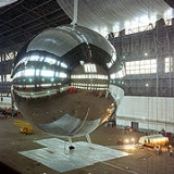
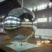
Echo 1 and Echo 2 balloon satellites
The first flying body of this type was Echo 1, which was launched into a 1600 kilometres (994.2 mi) high orbitOrbit
In physics, an orbit is the gravitationally curved path of an object around a point in space, for example the orbit of a planet around the center of a star system, such as the Solar System...
on August 12, 1960 by the United States. It originally had a spherical shape measuring 30 metres (98.4 ft), with a thin metal-coated plastic shell made of Mylar. It served for testing as a "passive" communication and geodetic
Geodesy
Geodesy , also named geodetics, a branch of earth sciences, is the scientific discipline that deals with the measurement and representation of the Earth, including its gravitational field, in a three-dimensional time-varying space. Geodesists also study geodynamical phenomena such as crustal...
satellite. Its international COSPAR
COSPAR
The Committee on Space Research was established by the International Council for Science in 1958.Among COSPAR's objectives are the promotion of scientific research in space on an international level, with emphasis on the free exchange of results, information, and opinions, and providing a forum,...
number was 6000901 (9th satellite launched in 1960, 1st component).
One of the first radio contacts using the satellite was successful at a distance of nearly 80000 kilometres (49,709.8 mi) (between the east coast of the US and California). By the time Echo 1 burned up in 1968, the measurements of its orbit by several dozen earth stations had improved our knowledge of the precise shape of the planet by nearly a factor of ten.
Its successor was the similarly built Echo 2
Echo 2
The Echo 2 was a speech synthesizer card for the Apple 2 and Apple //c personal computers. The Echo 2 used the TMS5220 speech synthesis chip, which could accept either phonemes or raw LPC data, with resulting higher speech quality.- The Original Echo 2 :...
(1964 to about 1970). This satellite circled the Earth about 400 kilometres (248.5 mi) lower, not at an angle of 47° like that of Echo 1, but in a polar orbit with an average angle of 81°. This enabled radio contact and measurements to be made at higher latitudes. Taking part in the Echo orbit checks to analyze disturbances in its orbit and in the Earth's gravitational field were thirty to fifty professional earth stations, as well as around two hundred amateur astronomer
Astronomer
An astronomer is a scientist who studies celestial bodies such as planets, stars and galaxies.Historically, astronomy was more concerned with the classification and description of phenomena in the sky, while astrophysics attempted to explain these phenomena and the differences between them using...
s across the planet in "Moonwatch" stations; these contributed around half of all sightings.
Range of radio waves, visibility
The Pythagorean theoremPythagorean theorem
In mathematics, the Pythagorean theorem or Pythagoras' theorem is a relation in Euclidean geometry among the three sides of a right triangle...
allows us to calculate easily how far a satellite is visible at such a great height. It can be determined that a satellite in a 1500 kilometres (932.1 mi) orbit rises and sets when the horizontal distance is 4600 kilometres (2,858.3 mi). However, the atmosphere causes this figure to vary slightly. Thus if two radio stations are 9000 kilometres (5,592.4 mi) apart and the satellite's orbit goes between them, they may be able to receive each other's reflected radio signals if the signals are strong enough.
Optical visibility is, however, lower than that of radio waves, because
- the satellite must be illuminated by the sun
- the observer needs a dark sky (that is, he must be in the Earth's own shadow on the planet's twilight or night side)
- the brightness of a sphere depends on the angle between the incident light and the observer (see phases of the moon)
- the brightness of a sphere is much reduced as it approaches the horizon, as atmospheric extinctionExtinction (astronomy)Extinction is a term used in astronomy to describe the absorption and scattering of electromagnetic radiation by matter between an emitting astronomical object and the observer. Interstellar extinction—also called Galactic extinction, when it occurs in the Milky Way—was first...
swallows up as much as 90% of the light
Despite this there is no problem observing a flying body such as Echo 1 for precise purposes of satellite geodesy, down to a 20° elevation, which corresponds to a distance of 2900 kilometres (1,802 mi). In theory this means that distances of up to 5000 kilometres (3,106.9 mi) between measuring points can be "bridged", and in practice this can be accomplished at up to 3000 –.
For visual and photographic observation of bright satellites and balloons, and regarding their geodetic use, see Echo 1 and Pageos
PAGEOS
PAGEOS was a balloon satellite which was launched by the NASA in June 1966. Pageos had a diameter of exactly , consisted of a thick mylar plastic film coated with vapour deposited aluminium enclosing a volume of and was used for the Weltnetz der Satellitentriangulation -- a global cooperation...
for further information.
Other balloon satellites
For special testing purposes two or three satellites of the ExplorerExplorer program
The Explorer program is a United States space exploration program that provides flight opportunities for physics, heliophysics, and astrophysics investigations from space. Over 90 space missions have been launched from 1958 to 2011, and it is still active...
series were constructed as balloons (possibly Explorer 19 and 38).
Echo 1 was an acknowledged success of radio engineering, but the passive principle of telecommunications (reflection of radio waves on the balloon's surface) was soon replaced by active systems. Telstar 1 (1962) and Early Bird
Early Bird
Early Bird may refer to:*A "lark", or "morning person", who usually gets up early in the morning and goes to bed early in the evening*An "early bird sale", also known as a Doorbuster...
(1965) were able to transmit several hundred audio channels simultaneously in addition to a television program exchanged between continents.
Satellite geodesy with Echo 1 and 2 was able to fulfill all expectations not only for the planned 2–3 years, but for nearly 10 years. For this reason NASA
NASA
The National Aeronautics and Space Administration is the agency of the United States government that is responsible for the nation's civilian space program and for aeronautics and aerospace research...
soon planned the launch of the even larger 40 metres (131.2 ft) balloon Pageos
PAGEOS
PAGEOS was a balloon satellite which was launched by the NASA in June 1966. Pageos had a diameter of exactly , consisted of a thick mylar plastic film coated with vapour deposited aluminium enclosing a volume of and was used for the Weltnetz der Satellitentriangulation -- a global cooperation...
. The name is from "passive geodesic satellite", and sounds similar to "Geos", a successful active electronic satellite from 1965.
Pageos and the global network
PAGEOS
PAGEOS was a balloon satellite which was launched by the NASA in June 1966. Pageos had a diameter of exactly , consisted of a thick mylar plastic film coated with vapour deposited aluminium enclosing a volume of and was used for the Weltnetz der Satellitentriangulation -- a global cooperation...
was specially launched for the "global network of satellite geodesy
Geodetic network
A geodetic network is a network of triangles which are measured exactly by techniques of terrestrial surveying or by satellite geodesy.In "classical geodesy" this is done by triangulation, based on measurements of angles and of some spare distances; the precise orientation to the geographic north...
", which occupied about 20 full-time observing teams all over the world until 1973. All together they recorded 3000 usable photographic plates from 46 tracking stations with calibrated all-electronic BC-4 cameras (1:3 / focal length 30 centimetre). From these images they were able to calculate the stations' position three-dimensionally with a precision of about 4 metres (13.1 ft). The coordinator of this project was Professor H. H. Schmid, from the ETH Zurich
Eth
Eth is a letter used in Old English, Icelandic, Faroese , and Elfdalian. It was also used in Scandinavia during the Middle Ages, but was subsequently replaced with dh and later d. The capital eth resembles a D with a line through the vertical stroke...
.
Three stations of the global network were situated in Europe: Catania in Sicily
Sicily
Sicily is a region of Italy, and is the largest island in the Mediterranean Sea. Along with the surrounding minor islands, it constitutes an autonomous region of Italy, the Regione Autonoma Siciliana Sicily has a rich and unique culture, especially with regard to the arts, music, literature,...
, Hohenpeißenberg in Bavaria
Bavaria
Bavaria, formally the Free State of Bavaria is a state of Germany, located in the southeast of Germany. With an area of , it is the largest state by area, forming almost 20% of the total land area of Germany...
and Tromsø
Tromsø
Tromsø is a city and municipality in Troms county, Norway. The administrative centre of the municipality is the city of Tromsø.Tromsø city is the ninth largest urban area in Norway by population, and the seventh largest city in Norway by population...
in northern Norway
Norway
Norway , officially the Kingdom of Norway, is a Nordic unitary constitutional monarchy whose territory comprises the western portion of the Scandinavian Peninsula, Jan Mayen, and the Arctic archipelago of Svalbard and Bouvet Island. Norway has a total area of and a population of about 4.9 million...
. For the completion of the navigational network exact distance measurements were needed; these were taken on four continents and across Europe with a precision of 0.5 millimetre (0.0196850393700787 in) per kilometer.
The global network enabled the calculation of a "geodetic date" (the geocentric position of the measurement system) on different continents, within a few meters. By the early 1970s reliable values for nearly 100 coefficients of the Earth's gravity field could be calculated.
1965-1975: Success with flashing light beacons
Bright balloon satellites are well visible and were measurable on fine-grained (less sensitive) photographic plates, even at the beginning of space travel, but there were problems with the exact chronometry of a satellite's track. In those days it could only be determined within a few milliseconds.Since satellites circle the earth at about 7 –, a time error of 0.002 second translates into a deviation of about 15 metres (49.2 ft). In order to meet a new goal of measuring the tracking stations precisely within a couple of years, a method of flashing light beacons was adopted around 1960.
To build a three-dimensional measuring network, geodesy needs exactly defined target points, more so than a precise time. This precision is easily reached by having two tracking stations record the same series of flashes from one satellite.
Flash technology was already mature in 1965 when the small electronic satellite Geos (later named Geos 1) was launched; along with its companion Geos 2, it brought about a remarkable increase in precision.
From about 1975 on, almost all optical measurement methods lost their importance, as they were overtaken by speedy progress in electronic distance measurement. Only newly developed methods of observation using CCD
Charge-coupled device
A charge-coupled device is a device for the movement of electrical charge, usually from within the device to an area where the charge can be manipulated, for example conversion into a digital value. This is achieved by "shifting" the signals between stages within the device one at a time...
and the highly precise star positions of the astrometry
Astrometry
Astrometry is the branch of astronomy that involves precise measurements of the positions and movements of stars and other celestial bodies. The information obtained by astrometric measurements provides information on the kinematics and physical origin of our Solar System and our Galaxy, the Milky...
satellite Hipparcos
Hipparcos
Hipparcos was a scientific mission of the European Space Agency , launched in 1989 and operated between 1989 and 1993. It was the first space experiment devoted to precision astrometry, the accurate measurement of the positions of celestial objects on the sky...
made further improvement possible in the measurement of distance.