

Ballona Wetlands
Encyclopedia
Southern California
Southern California is a megaregion, or megapolitan area, in the southern area of the U.S. state of California. Large urban areas include Greater Los Angeles and Greater San Diego. The urban area stretches along the coast from Ventura through the Southland and Inland Empire to San Diego...
, USA south of Marina del Rey and east of Playa del Rey. The wetlands once included the areas now taken up by Marina del Rey, Venice, and Playa Vista, extending north to about present-day Washington Blvd. in Venice.
It is one of the last significant wetland
Wetland
A wetland is an area of land whose soil is saturated with water either permanently or seasonally. Wetlands are categorised by their characteristic vegetation, which is adapted to these unique soil conditions....
s area in the Los Angeles basin
Los Angeles Basin
The Los Angeles Basin is the coastal sediment-filled plain located between the Peninsular and Transverse ranges in southern California in the United States containing the central part of the city of Los Angeles as well as its southern and southeastern suburbs...
, and is named for Ballona Creek
Ballona Creek
Ballona Creek is an waterway in southwestern Los Angeles County, California, whose watershed drains the Los Angeles basin, from the Santa Monica Mountains on the north, the Harbor Freeway on the east, and the Baldwin Hills on the south...
which now runs through the area as a flood control channel. In the 1930s the Ballona Creek corridor was channelized in concrete, thus greatly reducing the inflow of salt water to the marsh, and eliminating spring floods which brought freshwater to the wetlands.
Mexican ranchos and early American era
Water control
The Ballona CreekBallona Creek
Ballona Creek is an waterway in southwestern Los Angeles County, California, whose watershed drains the Los Angeles basin, from the Santa Monica Mountains on the north, the Harbor Freeway on the east, and the Baldwin Hills on the south...
Flood control channel
Flood control channel
Flood control channels are a series of large and empty open-air channels that extend a ways below the street levels of some larger cities, so that if and when a flood occurs, the flood will run into the channels, and proceed to be drained to the proper body of water...
, and the construction of Marina del Rey in the late 1950s, reduced the 2100 acres (8.5 km²) estuary to some 700 acres (2.8 km²). Additional open space east of the wetlands was converted to agricultural uses by the early 20th century, with cultivation continuing into the 1990s, when these became some of the last farm fields in the Los Angeles Basin. In the 1940s, much of these farm fields became the private Hughes Airport. In first decade of the 21st century that land was developed as Playa Vista
Playa Vista, Los Angeles, California
Playa Vista is a neighborhood located located on in the northern section of Westchester in the western area of Los Angeles, California, north of LAX...
, a planned mixed-use community east of Lincoln Boulevard.
Land owners and Issues
The State of California owned wetlandWetland
A wetland is an area of land whose soil is saturated with water either permanently or seasonally. Wetlands are categorised by their characteristic vegetation, which is adapted to these unique soil conditions....
s, just over 600 acres (2.4 km²), are crossed by Culver Boulevard, from Playa Del Rey to Culver City, and bordered by the 90 Marina freeway to the east. 83 acres (335,889.4 m²) of the Ballona Creek estuary were included in the state acquisition, previously privately owned by Howard Hughes, his corporate heirs and the subsequent developers of Playa Vista.
These estuary wetlands, and the remaining open space, have been the subject of a battle between developers and environmentalists that has been ongoing for decades. Numerous environmental lawsuits and the acquisition of a part of the Wetlands by the State of California has helped to protect a portion of this area, including nearly all the open space west of Lincoln Blvd. (including all of the remaining tidal wetlands). In 2002, remains of California Native American Tongva villages, artifacts, and buried ancestors were found during excavation on the Playa Vista site.
Flora - plants
The Ballona Wetlands, is a habitat of a marine EstuaryEstuary
An estuary is a partly enclosed coastal body of water with one or more rivers or streams flowing into it, and with a free connection to the open sea....
with its surrounding ecosystems. Historically the outlet-mouth of the Los Angeles River
Los Angeles River
The Los Angeles River is a river that starts in the San Fernando Valley, in the Simi Hills and Santa Susana Mountains, and flows through Los Angeles County, California, from Canoga Park in the western end of the San Fernando Valley, nearly southeast to its mouth in Long Beach...
switched, between San Pedro Bay
San Pedro Bay
San Pedro Bay may refer to:* San Pedro Bay , a small bay on Leyte* San Pedro Bay , an inlet on the Pacific coast of the United States* San Pedro Bay , a swamp and wildlife management area in north central Florida...
and the Ballona creek watercourse to Santa Monica Bay
Santa Monica Bay
Santa Monica Bay is a bight of the Pacific Ocean in southern California, United States. Its boundaries are slightly ambiguous, but it is generally considered to be the part of the Pacific within an imaginary line drawn between Point Dume, in Malibu, and the Palos Verdes Peninsula. Its eastern...
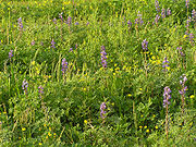
, several times a century. It last came through Ballona in the early 19th century. The alluvium it left makes up the soils below. Some unique plants here are: the Ballona Wallflower, Southern Tarplant, Lewis' Primrose, and Lupines.
Chaenactis glabriuscula
Chaenactis glabriuscula
Chaenactis glabriuscula, with the common name Yellow pincushion, is a species of flowering plant in the daisy family. It is native to California and Baja California.-Distribution:...
var. orcuttiana — Orcutt's yellow pincushion, is a rare native plant
Native plant
Native plant is a term to describe plants endemic or naturalized to a given area in geologic time.This includes plants that have developed, occur naturally, or existed for many years in an area...
limited to the coastal dunes of southern California. The Ballona Wetlands and Bell Avenue Sand Dune Park
Sand Dune Park
Sand Dune Park is an area of public sand dunes partly on a steep slope that is used for exercise in Manhattan Beach, California. The area has been used by amateur and professional athletes and has been featured in fitness magazines and newspaper accounts as a great workout spot...
in Manhattan Beach
Manhattan Beach, California
Manhattan Beach is the wealthiest beachfront city located in southwestern Los Angeles County, California, USA. The city is on the Pacific coast, south of El Segundo, and north of Hermosa Beach. Manhattan Beach is the home of both beach and indoor volleyball, and surfing. During the winter, the...
, each had var. orcuttiana populations newly discovered in Spring 2010. The variety is listed by the California Native Plant Society as endemic to California coastal dunes ecosystem
Ecosystem
An ecosystem is a biological environment consisting of all the organisms living in a particular area, as well as all the nonliving , physical components of the environment with which the organisms interact, such as air, soil, water and sunlight....
s and significantly declining.
Fauna
The estuary is home for such wildlife as: Great Blue Heron and Snowy Egret rookeries, the California Killifish, the California Least TernCalifornia Least Tern
The Least Tern is a species of tern that breeds in North America and locally in northern South America. It is closely related to, and was formerly often considered conspecific with, the Little Tern of the Old World...
, and the Belding's Savannah sparrow. The Ballona Wetlands and the adjacent city-owned lagoons are a stop along the migratory Pacific Flyway
Pacific Flyway
The Pacific Flyway is a major north-south route of travel for migratory birds in America, extending from Alaska to Patagonia. Every year, migratory birds travel some or all of this distance both in spring and in fall, following food sources, heading to breeding grounds, or travelling to...
.
See also
- Ballona CreekBallona CreekBallona Creek is an waterway in southwestern Los Angeles County, California, whose watershed drains the Los Angeles basin, from the Santa Monica Mountains on the north, the Harbor Freeway on the east, and the Baldwin Hills on the south...
- Santa Monica BaySanta Monica BaySanta Monica Bay is a bight of the Pacific Ocean in southern California, United States. Its boundaries are slightly ambiguous, but it is generally considered to be the part of the Pacific within an imaginary line drawn between Point Dume, in Malibu, and the Palos Verdes Peninsula. Its eastern...
- Wildlife corridorWildlife corridorA wildlife corridor or green corridor is an area of habitat connecting wildlife populations separated by human activities . This allows an exchange of individuals between populations, which may help prevent the negative effects of inbreeding and reduced genetic diversity that often occur within...
- Coastal and Estuarine Research FederationCoastal and Estuarine Research FederationThe Coastal and Estuarine Research Federation is a private, nonprofit organization that was created in 1971. At that time, the members of two regionally-based organizations, the Atlantic Estuarine Research Society and the New England Estuarine Research Society recognized the need for a third...
- Estuaries and CoastsEstuaries and CoastsEstuaries and Coasts is a peer-reviewed scientific journal published by Springer Science+Business Media and the official journal of the Coastal and Estuarine Research Federation. It was established in 1960 as Chesapeake Science by Romeo J. Mansueti, covering research results and management studies...
- Los Angeles RiverLos Angeles RiverThe Los Angeles River is a river that starts in the San Fernando Valley, in the Simi Hills and Santa Susana Mountains, and flows through Los Angeles County, California, from Canoga Park in the western end of the San Fernando Valley, nearly southeast to its mouth in Long Beach...
(history)