

Santa Monica Bay
Encyclopedia
Bight (geography)
In geography, bight has two meanings. A bight can be simply a bend or curve in any geographical feature—usually a bend or curve in the line between land and water....
of the Pacific Ocean
Pacific Ocean
The Pacific Ocean is the largest of the Earth's oceanic divisions. It extends from the Arctic in the north to the Southern Ocean in the south, bounded by Asia and Australia in the west, and the Americas in the east.At 165.2 million square kilometres in area, this largest division of the World...
in southern California
California
California is a state located on the West Coast of the United States. It is by far the most populous U.S. state, and the third-largest by land area...
, United States
United States
The United States of America is a federal constitutional republic comprising fifty states and a federal district...
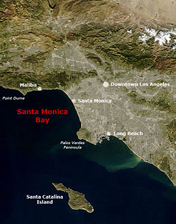
. Its boundaries are slightly ambiguous, but it is generally considered to be the part of the Pacific within an imaginary line drawn between Point Dume, in Malibu, and the Palos Verdes Peninsula. Its eastern shore forms the western boundary of the Los Angeles Westside and South Bay
South Bay, Los Angeles
The South Bay is a region of the southwest peninsula of Los Angeles County, California, United States. The name stems from its geographic features stretching along the southern shores of Santa Monica Bay which forms its western border.The picture at right uses the broadest definition of the...
regions. Although it was fed by the Los Angeles River
Los Angeles River
The Los Angeles River is a river that starts in the San Fernando Valley, in the Simi Hills and Santa Susana Mountains, and flows through Los Angeles County, California, from Canoga Park in the western end of the San Fernando Valley, nearly southeast to its mouth in Long Beach...
prior to the river's catastrophic change in course in 1825, the only stream of any size now flowing into it is Ballona Creek
Ballona Creek
Ballona Creek is an waterway in southwestern Los Angeles County, California, whose watershed drains the Los Angeles basin, from the Santa Monica Mountains on the north, the Harbor Freeway on the east, and the Baldwin Hills on the south...
. Other waterways draining into the bay include Malibu Creek
Malibu Creek
Malibu Creek is a year-round stream in western Los Angeles County, California. It drains the southern Simi Hills and the westernmost San Fernando Valley, flows south through the Santa Monica Mountains, and enters Santa Monica Bay east of Malibu. The Malibu Creek watershed drains and its tributary...
, and Topanga Creek.
State beaches include Malibu Lagoon State Beach (Surfrider), Will Rogers State Beach
Will Rogers State Beach
Will Rogers State Beach is a beach park on the Santa Monica Bay, at the Pacific coast of Southern California. It is located in Pacific Palisades and Santa Monica, Los Angeles County, California, and is protected as part of the California Department of Parks and Recreation...
, Santa Monica State Beach
Santa Monica State Beach
Santa Monica State Beach is a California State Park operated by the city of Santa Monica.-Santa Monica Beach:The beach is located along Pacific Coast Highway in Santa Monica...
, and Dockweiler State Beach
Dockweiler State Beach
Dockweiler State Beach is a Los Angeles beach protected under the state park system. Part of the park is located directly under the flight path of the immediately adjacent Los Angeles International Airport. Additionally, it is one of the few beaches in Los Angeles County where bonfires are permitted...
.
Several piers extend into the bay, including Malibu Pier, Santa Monica Pier
Santa Monica Pier
The Santa Monica Pier is a large double-jointed pier located at the foot of Colorado Avenue in Santa Monica, California and is a prominent, 100-year-old landmark.-Pacific Park:...
, Venice Pier, Manhattan Beach pier
Manhattan Beach pier
The Manhattan Beach Pier is a pier located in Manhattan Beach, California on the Pacific Ocean coast. The pier is long and located at the end of Manhattan Beach Boulevard. An octagonal Mediterranean-style building sits at the end of the pier and houses the Roundhouse Marine Studies Lab & Aquarium...
, Hermosa Beach pier
Hermosa Beach pier
The Hermosa Beach pier is located in the Southern California community of Hermosa Beach. It extends into the Pacific Ocean.In 1904 the first pier was built. It was constructed entirely of wood even to the pilings and it extended five hundred feet out into the ocean. The pier was constructed by the...
, and Redondo Beach pier
Redondo Beach pier
The Redondo Beach pier is located in Redondo Beach, California and stretches out onto the Pacific Ocean. The pier has been rebuilt and altered by storms and redevelopments. Its official name is "Municipal Pier", and it has also been called the "Endless Pier"...
. Marina Del Rey is a dredged marina. Chevron Reef
Chevron Reef
Chevron Reef, also known as Pratte's Reef, is an artificial reef constructed in 2000 in Santa Monica Bay, offshore from Dockweiler State Beach...
is an artificial surfing reef in the bay.
History
In the 1930s, gambling ships anchored beyond the three mile limit, then measured from the beach. The ships were popular and a fleet of ever-larger ships and barges appeared until the State Attorney General got the limit recalculated to exclude the bay. The largest ship held off the state police for nine days with submachine gunSubmachine gun
A submachine gun is an automatic carbine, designed to fire pistol cartridges. It combines the automatic fire of a machine gun with the cartridge of a pistol. The submachine gun was invented during World War I , but the apex of its use was during World War II when millions of the weapon type were...
s in what the newspapers called The Battle of Santa Monica Bay.
Once a major commercial fishery
Fishing
Fishing is the activity of trying to catch wild fish. Fish are normally caught in the wild. Techniques for catching fish include hand gathering, spearing, netting, angling and trapping....
, Santa Monica Bay's water quality declined drastically in the 20th century as development of Los Angeles County
Los Angeles County, California
Los Angeles County is a county in the U.S. state of California. As of 2010 U.S. Census, the county had a population of 9,818,605, making it the most populous county in the United States. Los Angeles County alone is more populous than 42 individual U.S. states...
resulted in large amounts of sewage
Sewage
Sewage is water-carried waste, in solution or suspension, that is intended to be removed from a community. Also known as wastewater, it is more than 99% water and is characterized by volume or rate of flow, physical condition, chemical constituents and the bacteriological organisms that it contains...
and trash-rich storm runoff being dumped into its waters. Through restoration projects mandated by the Clean Water Act
Clean Water Act
The Clean Water Act is the primary federal law in the United States governing water pollution. Commonly abbreviated as the CWA, the act established the goals of eliminating releases of high amounts of toxic substances into water, eliminating additional water pollution by 1985, and ensuring that...
and advocated by groups such as Heal the Bay
Heal the Bay
Heal the Bay is a U.S. environmental advocacy non-profit organization based in Santa Monica, California.Heal the Bay is dedicated to protecting California's Santa Monica Bay, a region of the Pacific coast encompassed by Malibu's Point Dume on the north and the Palos Verdes Peninsula on the south...
, the bay's water quality has improved fairly dramatically from its early-1980s nadir. Hyperion sewage treatment plant
Hyperion sewage treatment plant
The Hyperion Wastewater Treatment plant is located in southwest Los Angeles, California, next to Dockweiler State Beach on Santa Monica Bay. The largest wastewater treatment facility in the Los Angeles Metropolitan Area, Hyperion is operated by the City of Los Angeles, Department of Public Works,...
's output is now far cleaner than it had been. However, during the region's rainy winters, it still suffers from algal bloom
Algal bloom
An algal bloom is a rapid increase or accumulation in the population of algae in an aquatic system. Algal blooms may occur in freshwater as well as marine environments. Typically, only one or a small number of phytoplankton species are involved, and some blooms may be recognized by discoloration...
and other water pollution
Water pollution
Water pollution is the contamination of water bodies . Water pollution occurs when pollutants are discharged directly or indirectly into water bodies without adequate treatment to remove harmful compounds....
-related maladies, forcing the closure of most of the famous beaches along its shore.
Communities and settlements
- Malibu
- Pacific PalisadesPacific Palisades, Los Angeles, CaliforniaPacific Palisades is an affluent neighborhood and district within the U.S. city of Los Angeles, California, located among Brentwood to the east, Malibu and Topanga to the west, Santa Monica to the southeast, the Santa Monica Bay to the southwest, and the Santa Monica Mountains to the north. The...
- Santa MonicaSanta Monica, CaliforniaSanta Monica is a beachfront city in western Los Angeles County, California, US. Situated on Santa Monica Bay, it is surrounded on three sides by the city of Los Angeles — Pacific Palisades on the northwest, Brentwood on the north, West Los Angeles on the northeast, Mar Vista on the east, and...
- VeniceVenice, Los Angeles, CaliforniaVenice is a beachfront district on the Westside of Los Angeles, California, United States. It is known for its canals, beaches and circus-like Ocean Front Walk, a two-and-a-half mile pedestrian-only promenade that features performers, fortune-tellers, artists, and vendors...
- Marina del ReyMarina del Rey, California-Demographics:-2010:The 2010 United States Census reported that Marina del Rey had a population of 8,866. The population density was 6,094.6 people per square mile...
- Playa del ReyPlaya del Rey, Los Angeles, CaliforniaPlaya del Rey is a beachside community within the city of Los Angeles, California. It has a ZIP code of 90293 and area codes of 310 and 424...
- El SegundoEl Segundo, CaliforniaEl Segundo is a city in Los Angeles County, California, United States. Located on the Santa Monica Bay, it was incorporated on January 18, 1917, and is one of the Beach Cities of Los Angeles County and part of the South Bay Cities Council of Governments...
- El PortoEl Porto, Manhattan Beach, CaliforniaEl Porto is a beach community that is part of Manhattan Beach, a city in the South Bay area of Greater Los Angeles in Southern California.The boundary of El Porto is 45th Street on the north side, which is the border with El Segundo, and its Chevron oil refinery, to 38th Street, which was the old...
- Manhattan BeachManhattan Beach, CaliforniaManhattan Beach is the wealthiest beachfront city located in southwestern Los Angeles County, California, USA. The city is on the Pacific coast, south of El Segundo, and north of Hermosa Beach. Manhattan Beach is the home of both beach and indoor volleyball, and surfing. During the winter, the...
- Hermosa BeachHermosa Beach, CaliforniaHermosa Beach is a beachfront city in Los Angeles County, California, United States. Its population was 19,506 at the 2010 census, up from 18,566 at the 2000 census....
- Redondo BeachRedondo Beach, CaliforniaRedondo Beach is one of the three Beach Cities located in Los Angeles County, California, United States. The population was 66,748 at the 2010 census, up from 63,261 at the 2000 census. The city is located in the South Bay region of the greater Los Angeles area.Redondo Beach was originally part of...
- TorranceTorrance, CaliforniaTorrance is a city incorporated in 1921 and located in the South Bay region of Los Angeles County, California, United States. Torrance has of shore-front beaches on the Pacific Ocean, quieter and less well-known by tourists than others on the Santa Monica Bay, such as those of neighboring...
- Palos Verdes EstatesPalos Verdes Estates, CaliforniaPalos Verdes Estates is a city, incorporated in 1939, in Los Angeles County, California, USA on the Palos Verdes Peninsula. The city was masterplanned by the noted American landscape architect and planner Frederick Law Olmsted, Jr. The population was 13,438 at the 2010 census, up from 13,340 in the...
- Rancho Palos VerdesRancho Palos Verdes, CaliforniaRancho Palos Verdes is a city in Los Angeles County, California that was incorporated on September 7, 1973. The population was 41,643 at the 2010 census...