

Balclutha Road Bridge
Encyclopedia
Clutha River
The Clutha River / Mata-Au is the second longest river in New Zealand flowing south-southeast through Central and South Otago from Lake Wanaka in the Southern Alps to the Pacific Ocean, south west of Dunedin. It is the highest volume river in New Zealand, and the swiftest, with a catchment of ,...
in Balclutha
Balclutha, New Zealand
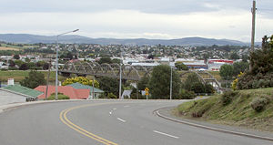
Balclutha is a town in Otago, it lies towards the end of the Clutha River on the east coast of the South Island of New Zealand. It is about halfway between Dunedin and Invercargill on the Main South Line railway, State Highway 1 and the Southern Scenic Route...
, South Otago
South Otago
South Otago lies in the south east of the South Island of New Zealand. As the name suggests, it forms the southernmost part of the geographical region of Otago....
, New Zealand
New Zealand
New Zealand is an island country in the south-western Pacific Ocean comprising two main landmasses and numerous smaller islands. The country is situated some east of Australia across the Tasman Sea, and roughly south of the Pacific island nations of New Caledonia, Fiji, and Tonga...
, is one of the best-known road bridges in New Zealand's South Island
South Island
The South Island is the larger of the two major islands of New Zealand, the other being the more populous North Island. It is bordered to the north by Cook Strait, to the west by the Tasman Sea, to the south and east by the Pacific Ocean...
. The bridge is often simply known as "The Clutha Bridge", despite the fact that there are numerous bridges across the country's second longest river.
Built between 1933 and 1935, this bowstring bridge was designed by W. L. Newnham to be earthquake and flood resistant, thereby safeguarding it against the two commonest natural disasters to occur in southern New Zealand.
The bridge is built from reinforced concrete, with six parabolic curved spans, each of 36.6 metres in length, and a total bridge length of 244.1 metres. A carriageway of 6.7 metres width is flanked on either side by a footpath of 1.4 metres; its total width is 11.8 metres. The bridge carries the South Island's principal highway, State Highway 1
State Highway 1 (New Zealand)
State Highway 1 is the longest and most significant road in the New Zealand roading network, running the length of both main islands. It appears on road maps as SH 1 and on road signs as a white number 1 on a red shield, but it has the official designations SH 1N in the North Island, SH 1S in the...
on its route between Dunedin
Dunedin
Dunedin is the second-largest city in the South Island of New Zealand, and the principal city of the Otago Region. It is considered to be one of the four main urban centres of New Zealand for historic, cultural, and geographic reasons. Dunedin was the largest city by territorial land area until...
and Invercargill
Invercargill
Invercargill is the southernmost and westernmost city in New Zealand, and one of the southernmost cities in the world. It is the commercial centre of the Southland region. It lies in the heart of the wide expanse of the Southland Plains on the Oreti or New River some 18 km north of Bluff,...
.
The bridge is the third road bridge to stand at or close to this spot. The first, constructed in 1868, was destroyed in massive floods ten years later when a bridge situated upstream at Beaumont
Beaumont, New Zealand
Beaumont is a small town in inland Otago, in the South Island of New Zealand. It is located on the Clutha River six kilometres southeast of Raes Junction, between Roxburgh and Balclutha...
was swept downriver and collided with it. A second bridge was constructed in 1881, but was unsuitable for the needs of motorised transport and was eventually replaced by the current structure.
On 13 December 1990 the Balclutha Road Bridge was classified as a Category I Historic Place by the New Zealand Historic Places Trust
New Zealand Historic Places Trust
The New Zealand Historic Places Trust is a non-profit trust that advocates for the protection of ancestral sites and heritage buildings in New Zealand...
.
Another bridge, the Balclutha Rail Bridge, stands several hundred metres downstream.