

Aylesbury Urban Area
Encyclopedia
The Aylesbury Urban Area is defined by the Office for National Statistics
as a conurbation in central Buckinghamshire
, England
. It had a population of 69,021 (2001 census). The largest population centre is Aylesbury
itself at 56,392.
like others in the area such as Wendover
. It population in 1801 was 3082 with steady growth up to 9099 in 1901, a three-fold increase in 100 years. At the same time, villages and hamlets such Walton and New Zealand
grew slowly with separate identities to the growing town.
was creating a strain on the recently introduced Metropolitan Green Belt
and Aylesbury was one of the towns chosen for major population growth to house the London overspill
.
, built in 1814, was developed into a pedestrian square. The population reached 40,000 in 1970 and 51,000 by 1990, with new housing areas being built every few years. By 2001, the urban area housed 69,021 people.
district is expected to be around 215,000 people by 2026 with around half living in Aylesbury
, making the urban area population around 100,000 people.
and Stoke Mandeville
, both on the London to Aylesbury Line
. Before 1966, they were on the Great Central Main Line
with services north to Manchester
. There is also a line
to Princes Risborough
connecting with the Chiltern Main Line
.
. Chiltern Railways
have also suggested re-connecting the area with the north in the future http://www.southeast-ra.gov.uk/southeastplan/key/study_areas/draft_strategies/mkav/aylesbury_vale-draft_strategy.pdf.
s, or even a good quality bypass
. Improvements to the roads towards Milton Keynes
are underway however.
Office for National Statistics
The Office for National Statistics is the executive office of the UK Statistics Authority, a non-ministerial department which reports directly to the Parliament of the United Kingdom.- Overview :...
as a conurbation in central Buckinghamshire
Buckinghamshire
Buckinghamshire is a ceremonial and non-metropolitan home county in South East England. The county town is Aylesbury, the largest town in the ceremonial county is Milton Keynes and largest town in the non-metropolitan county is High Wycombe....
, England
England
England is a country that is part of the United Kingdom. It shares land borders with Scotland to the north and Wales to the west; the Irish Sea is to the north west, the Celtic Sea to the south west, with the North Sea to the east and the English Channel to the south separating it from continental...
. It had a population of 69,021 (2001 census). The largest population centre is Aylesbury
Aylesbury
Aylesbury is the county town of Buckinghamshire in South East England. However the town also falls into a geographical region known as the South Midlands an area that ecompasses the north of the South East, and the southern extremities of the East Midlands...
itself at 56,392.
Pre 20th Century
Aylesbury was, for hundreds of years, a typically small market townMarket town
Market town or market right is a legal term, originating in the medieval period, for a European settlement that has the right to host markets, distinguishing it from a village and city...
like others in the area such as Wendover
Wendover
Wendover is a market town that sits at the foot of the Chiltern Hills in Buckinghamshire, England. It is also a civil parish within Aylesbury Vale district...
. It population in 1801 was 3082 with steady growth up to 9099 in 1901, a three-fold increase in 100 years. At the same time, villages and hamlets such Walton and New Zealand
New Zealand, Buckinghamshire
New Zealand is a hamlet in the civil parish of Aylesbury, Buckinghamshire, England, on the A413 heading out to the north of Aylesbury town centre. It has been swallowed up by the urban growth of Aylesbury, but the public house of the same name remains today. It gained its name from a breed of cow...
grew slowly with separate identities to the growing town.
1900-1950
During the first half of the twentieth century, the population grew slightly more, reaching 21,200 in 1950. However, the rocketing population of the capital, LondonLondon
London is the capital city of :England and the :United Kingdom, the largest metropolitan area in the United Kingdom, and the largest urban zone in the European Union by most measures. Located on the River Thames, London has been a major settlement for two millennia, its history going back to its...
was creating a strain on the recently introduced Metropolitan Green Belt
Metropolitan Green Belt
The Metropolitan Green Belt is a statutory green belt around London, England. It includes designated parts of Greater London and the surrounding counties of Bedfordshire, Berkshire, Buckinghamshire, Essex, Hertfordshire, Kent and Surrey in the South East and East of England regions.-History:The...
and Aylesbury was one of the towns chosen for major population growth to house the London overspill
London overspill
London overspill is the term given to the communities created - largely consisting of publicly provided housing - as a result of the Government policy of moving residents out of Greater London, England into other towns around the South East, East Anglia and beyond.-Policy development:The policy...
.
1950-2000
The population of the town began to increase at a faster rate, as new housing estates were built. At the same time, the centre of Aylesbury was redeveloped, with new shopping areas. The area near the Aylesbury branch of the Grand Union CanalGrand Union Canal
The Grand Union Canal in England is part of the British canal system. Its main line connects London and Birmingham, stretching for 137 miles with 166 locks...
, built in 1814, was developed into a pedestrian square. The population reached 40,000 in 1970 and 51,000 by 1990, with new housing areas being built every few years. By 2001, the urban area housed 69,021 people.
Future
Aylesbury's growth is far from over, with major housing development in the north. Two major growth areas are Berryfields and Weedon Hill, with 3850 new homes as well as new services being constructed. The population of the Aylesbury ValeAylesbury Vale
The Aylesbury Vale is a large area of flat land mostly in Buckinghamshire, England. Its boundary is marked by Milton Keynes to the north, Leighton Buzzard and the Chiltern Hills to the east and south, Thame to the south and Bicester and Brackley to the west.The vale is named after Aylesbury, the...
district is expected to be around 215,000 people by 2026 with around half living in Aylesbury
Aylesbury
Aylesbury is the county town of Buckinghamshire in South East England. However the town also falls into a geographical region known as the South Midlands an area that ecompasses the north of the South East, and the southern extremities of the East Midlands...
, making the urban area population around 100,000 people.
Reasons for growth
The Vale of Aylesbury is a large flat area of land, and therefore ideal for urban development. From the 19th century onwards, other major factors contributing to the growth of Aylesbury were:- 1814- The opening of the Grand Union CanalGrand Union CanalThe Grand Union Canal in England is part of the British canal system. Its main line connects London and Birmingham, stretching for 137 miles with 166 locks...
branch to LondonLondonLondon is the capital city of :England and the :United Kingdom, the largest metropolitan area in the United Kingdom, and the largest urban zone in the European Union by most measures. Located on the River Thames, London has been a major settlement for two millennia, its history going back to its...
and BirminghamBirminghamBirmingham is a city and metropolitan borough in the West Midlands of England. It is the most populous British city outside the capital London, with a population of 1,036,900 , and lies at the heart of the West Midlands conurbation, the second most populous urban area in the United Kingdom with a... - 1839- Railway links to the London and Birmingham RailwayLondon and Birmingham RailwayThe London and Birmingham Railway was an early railway company in the United Kingdom from 1833 to 1846, when it became part of the London and North Western Railway ....
, today's West Coast Main LineWest Coast Main LineThe West Coast Main Line is the busiest mixed-traffic railway route in Britain, being the country's most important rail backbone in terms of population served. Fast, long-distance inter-city passenger services are provided between London, the West Midlands, the North West, North Wales and the...
in the form of the Cheddington to Aylesbury Line, the world's first branch lineBranch lineA branch line is a secondary railway line which branches off a more important through route, usually a main line. A very short branch line may be called a spur line...
. - 1865- First factories constructed
- 1892-Metropolitan RailwayMetropolitan railwayMetropolitan Railway can refer to:* Metropolitan line, part of the London Underground* Metropolitan Railway, the first underground railway to be built in London...
link to LondonLondonLondon is the capital city of :England and the :United Kingdom, the largest metropolitan area in the United Kingdom, and the largest urban zone in the European Union by most measures. Located on the River Thames, London has been a major settlement for two millennia, its history going back to its... - 1960s- new housing encourages people to move to Aylesbury.
Constituent Places
| Place | Population |
|---|---|
| Aylesbury Aylesbury Aylesbury is the county town of Buckinghamshire in South East England. However the town also falls into a geographical region known as the South Midlands an area that ecompasses the north of the South East, and the southern extremities of the East Midlands... |
56,392 |
| Fairford Leys Fairford Leys Fairford Leys is a new high density housing estate of 1,900 homes west of Aylesbury in Buckinghamshire, England. It has its own village centre with a number of traditionally fronted shops, a small supermarket, two restaurants, a nursery, an ecumenical church and a community centre. It also has a... |
6,363 |
| Watermead Watermead, Buckinghamshire Watermead is a housing estate, situated less than half a mile north of Aylesbury in Buckinghamshire, England, however, the spine road entrance is situated within Aylesbury. It is also a civil parish within Aylesbury Vale district. It is a very popular place to live for young couples and city... |
3,285 |
| Bierton Bierton Bierton is a village in Buckinghamshire, England, about half a mile northeast of the town of Aylesbury. It is a mainly farming parish, 10 km² in size.... |
1771 |
| Stoke Mandeville Stoke Mandeville Stoke Mandeville is a village and also a civil parish within Aylesbury Vale district to the south-east of Aylesbury in the county of Buckinghamshire, England. Although a separate civil parish, the village falls within the Aylesbury Urban Area... |
1,210 |
| TOTAL | 69,021 |
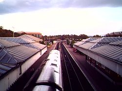
Railway
Today
There are two stations serving the urban area, AylesburyAylesbury railway station
Aylesbury railway station is a railway station in Aylesbury, Buckinghamshire, England and is a major stop on the London to Aylesbury Line from Marylebone station via Amersham. It is 37.75 miles from Aylesbury Station to Marylebone Station...
and Stoke Mandeville
Stoke Mandeville railway station
Stoke Mandeville railway station serves the village of Stoke Mandeville, to the south of Aylesbury in Buckinghamshire. The station lies on the London -Aylesbury line and is served by Chiltern Railways trains...
, both on the London to Aylesbury Line
London to Aylesbury Line
The London to Aylesbury Line is the main railway line between London and Aylesbury, going via the Chiltern Hills; it is operated by Chiltern Railways. The line includes the only route where National Rail trains use track that is utilized by London Underground services...
. Before 1966, they were on the Great Central Main Line
Great Central Main Line
The Great Central Main Line , also known as the London Extension of the Manchester, Sheffield and Lincolnshire Railway , is a former railway line which opened in 1899 linking Sheffield with Marylebone Station in London via Nottingham and Leicester.The GCML was the last main line railway built in...
with services north to Manchester
Manchester
Manchester is a city and metropolitan borough in Greater Manchester, England. According to the Office for National Statistics, the 2010 mid-year population estimate for Manchester was 498,800. Manchester lies within one of the UK's largest metropolitan areas, the metropolitan county of Greater...
. There is also a line
Princes Risborough to Aylesbury Line
The Princes Risborough to Aylesbury Line is a rural branch line from Princes Risborough to Aylesbury in Buckinghamshire, England.The line is single track throughout with a maximum speed of 40 mph....
to Princes Risborough
Princes Risborough
Princes Risborough is a small town in Buckinghamshire, England, about 9 miles south of Aylesbury and 8 miles north west of High Wycombe. Bledlow lies to the west and Monks Risborough to the east. It lies at the foot of the Chiltern Hills, at the north end of a gap or pass through the Chilterns,...
connecting with the Chiltern Main Line
Chiltern Main Line
The Chiltern Main Line is an inter-urban, regional and commuter railway, part of the British railway system. It links London and Birmingham on a 112-mile route via the towns of High Wycombe, Banbury, and Leamington Spa...
.
Future
To cater for the new housing developments, a new station will open on 14 December 2008 with the name Aylesbury Vale ParkwayAylesbury Vale Parkway railway station
Aylesbury Vale Parkway railway station is a railway station serving villages to the northwest of Aylesbury. It will also serve the Berryfields and Weedon Hill housing developments to the north of the town when these are completed. The station is served by Chiltern Railways and opened on 14 December...
. Chiltern Railways
Chiltern Railways
Chiltern Railways is a British train operating company. It was set up at the privatisation of British Rail in 1996, and operates local passenger trains from Marylebone station in London to Aylesbury and main-line trains on the Chiltern Main Line to Birmingham Snow Hill with its associated branches...
have also suggested re-connecting the area with the north in the future http://www.southeast-ra.gov.uk/southeastplan/key/study_areas/draft_strategies/mkav/aylesbury_vale-draft_strategy.pdf.
Road
Unlike other urban areas nearby, Aylesbury urban area has no motorway connection or major dual carriagewayDual carriageway
A dual carriageway is a class of highway with two carriageways for traffic travelling in opposite directions separated by a central reservation...
s, or even a good quality bypass
Bypass (road)
A bypass is a road or highway that avoids or "bypasses" a built-up area, town, or village, to let through traffic flow without interference from local traffic, to reduce congestion in the built-up area, and to improve road safety....
. Improvements to the roads towards Milton Keynes
Milton Keynes
Milton Keynes , sometimes abbreviated MK, is a large town in Buckinghamshire, in the south east of England, about north-west of London. It is the administrative centre of the Borough of Milton Keynes...
are underway however.