

Auraria, Georgia
Encyclopedia
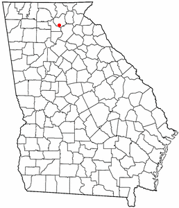
Lumpkin County, Georgia
Lumpkin County is a county located in the U.S. state of Georgia. As of the 2010 census, the population was 29,966. Its county seat is Dahlonega.- History :...
, Georgia
Georgia (U.S. state)
Georgia is a state located in the southeastern United States. It was established in 1732, the last of the original Thirteen Colonies. The state is named after King George II of Great Britain. Georgia was the fourth state to ratify the United States Constitution, on January 2, 1788...
, United States
United States
The United States of America is a federal constitutional republic comprising fifty states and a federal district...
, southwest of Dahlonega
Dahlonega, Georgia
Dahlonega is a city in Lumpkin County, Georgia, United States, and is its county seat. As of the 2010 census, the city had a population of 5,242....
. Its name derives from aurum, the Latin word for gold. In its early days, it was also known variously as Dean, Deans, Nuckollsville, and Scuffle Town.
History
In 1828, a man walked Findley Ridge, kicked a rock, and discovered it was full of gold. This was in Cherokee Indian territory, and part of present day Lumpkin County, Georgia. Settlers came to the Indian lands in search of gold during the ensuing Georgia Gold RushGeorgia Gold Rush
The Georgia Gold Rush was the second significant gold rush in the United States. It started in 1828 in the present day Lumpkin County near county seat Dahlonega, and soon spread through the North Georgia mountains, following the Georgia Gold Belt. By the early 1840s, gold became harder to find...
. The Indians were dismayed at the influx of unauthorized settlers. Cherokee Indian leader Major Ridge
Major Ridge
Major Ridge, The Ridge was a Cherokee Indian member of the tribal council, a lawmaker, and a leader. He was a veteran of the Chickamauga Wars, the Creek War, and the First Seminole War.Along with Charles R...
, along with his son John Ridge
John Ridge
John Ridge, born Skah-tle-loh-skee , was from a prominent family of the Cherokee Nation, then located in present-day Georgia. He married Sarah Bird Northup, of a New England family, whom he had met while studying at the Foreign Mission School in Cornwall, Connecticut...
and Stand Watie
Stand Watie
Stand Watie , also known as Standhope Uwatie, Degataga , meaning “stand firm”), and Isaac S. Watie, was a leader of the Cherokee Nation and a brigadier general of the Confederate States Army during the American Civil War...
, met with the United States and ceded the land in Georgia for land in Oklahoma. Most of the Cherokee Nation (under John Ross
John Ross (Cherokee chief)
John Ross , also known as Guwisguwi , was Principal Chief of the Cherokee Native American Nation from 1828–1866...
) protested the decision, but the Cherokee removal from Georgia, known as the Trail of Tears
Trail of Tears
The Trail of Tears is a name given to the forced relocation and movement of Native American nations from southeastern parts of the United States following the Indian Removal Act of 1830...
, began. The land east of Auraria was purchased by Vice President John Calhoun
John C. Calhoun
John Caldwell Calhoun was a leading politician and political theorist from South Carolina during the first half of the 19th century. Calhoun eloquently spoke out on every issue of his day, but often changed positions. Calhoun began his political career as a nationalist, modernizer, and proponent...
, and there he established the Calhoun Mine
Calhoun Mine
The Calhoun Mine is perhaps the oldest and best known mine in Lumpkin County, Georgia. When gold was discovered in Lumpkin County in 1828, which lead to the Georgia Gold Rush in 1829, it was discovered on owned by Robert Obar. After at least two intermediary sales, the land was purchased by...
. The banks of the Etowah River, Camp Creek, and Cane Creek had many mines (Barlow Mine, Battle Branch Mine
Battle Branch Mine
The Battle Branch Mine, sometimes referred to as the Battle Creek Mine, was located near the town of Auraria in Lumpkin County, Georgia. During the Georgia Gold Rush, before the Gold Lottery of 1832, men from several different states were all working in the same stream when a dispute over the...
, Ralston Mine, Whim Hill Mine, Hedwig-Chicago Mine, Gold Hill Mine Etowah Mine, and others).
Due to politics and land ownership, another nearby city was established, Dahlonega, Georgia
Dahlonega, Georgia
Dahlonega is a city in Lumpkin County, Georgia, United States, and is its county seat. As of the 2010 census, the city had a population of 5,242....
. Due to its location and political influence, Dahlonega received a Federal Mint for gold coins.
In 1848, gold was discovered in California. Former Auraria resident Jennie Wimmer, a cook in rural California, was the first person to prove the gold's authenticity, because she was the only person on the scene who knew how to perform the proper tests. This discovery led to the California gold rush
California Gold Rush
The California Gold Rush began on January 24, 1848, when gold was found by James W. Marshall at Sutter's Mill in Coloma, California. The first to hear confirmed information of the gold rush were the people in Oregon, the Sandwich Islands , and Latin America, who were the first to start flocking to...
of 1849. Discoveries of gold in California and soon after in Colorado caused Auraria to eventually fade into history. Gold mining in Georgia decreased and eventually all but ceased as miners went west looking for uncharted prospecting. Auraria's population quickly dwindled, and the community deteriorated.
William Greeneberry Russell
William Greeneberry Russell
William Greeneberry "Green" Russell was an American prospector and miner.Green Russell lived in Georgia and worked in the California gold fields in the 1850s. Russell was married to a Cherokee woman, and through his connections to the tribe, he heard about an 1849 discovery of gold along the...
and a party of men of Auraria who left for Kansas Territory
Kansas Territory
The Territory of Kansas was an organized incorporated territory of the United States that existed from May 30, 1854, until January 29, 1861, when the eastern portion of the territory was admitted to the Union as the State of Kansas....
formed the settlement of Auraria in 1858; the town later merged with Denver, Colorado
Denver, Colorado
The City and County of Denver is the capital and the most populous city of the U.S. state of Colorado. Denver is a consolidated city-county, located in the South Platte River Valley on the western edge of the High Plains just east of the Front Range of the Rocky Mountains...
.
Present day
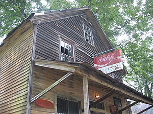
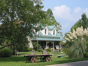
There are still a few old buildings standing: the collapsing Graham Hotel (in ruins; very unsafe to enter), Woody's store at Castleberry Bridge Road, that remained open till the early 1980s, a red house that was once a bank, another house across the street from that, and a couple of foundations. They stand in lone testament to the 19th century gold rush.Geography
Auraria is located at 34°28.5′N 84°1.4′W, at an elevation of 1401 feet (427m)To get to Auraria, go to the square in Dahlonega. Follow the west road to Dawsonville, pass the college (the gold-domed building is built on the foundation of the old mint). Turn left at the bottom of that hill and continue about 3 miles. The old red house on the left is the bank; after that, the collapsing building is the old hotel and just beyond on the left is the old Woody's store. Castleberry Bridge Road to the right leads down to the Etowah River.
Map: http://www.wikimapia.org/#y=34474678&x=-84024484&z=18&l=0&m=a&v=2