

Attappadi
Encyclopedia
Attappadi Reserve Forest
is a protected area
comprising 249 km² of land covering the westernmost part of the 745 km² Attappadi block of Mannarghat Taluk in Palakkad district
of Kerala
, south India
.
There is a Government Goat
Farm at Attapadi village which has the "Attapadi Black" breed available.
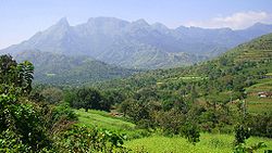
 Attappati is an extensive mountain valley
at the headwaters of the Bhavani River
nestled below the Nilgiri Hills of the Western Ghats
. It is bordered to the east by Coimbatore district
in Tamilnadu, on the north by the Nilgiris, south by the Palghat taluk and on the west by Karimba
, Pottassery and Mannarghat revenue villages of Mannarghat taluk of the Palghat District and Ernad taluk of the Malappuram district.
The 249 km² Attappadi Reserve Forest is an informal buffer zone
bordering the Silent Valley National Park
to the West. 81 km² of this forest was separated to become most of the new 94 km² Bhavani Forest Range which is part of the 147.22 km² Silent Valley Buffer Zone formally approved by the Kerala Cabinet on 6 June 2007. The Cabinet also sanctioned 35 staff to protect the area and two new forest stations in Bhavani range at Anavai and Thudukki. The zone is aimed at checking the illicit cultivation of ganja, poaching and illicit brewing in areas adjacent to Silent Valley and help long-term sustainability of the protected area.
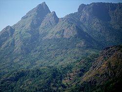 The elevation
of Attappati valley ranges from 750 metres (2,460.6 ft) to the Malleswaram peak at 11°6′32"N 76°33′8"E which rises to 1664 metres (5,459.3 ft) from the center of the valley. The Bhavani River flows from the Northwest around the mountain in a tight bend past Attappaddi village and continues to the Southeast.
, hornblende gneiss, migmaititic amphibolite, quartz biotite gneiss, quartz-feldspathic gneiss, biotite granite gneiss, and pegmatite
. Among the rock types charnockite, hornblende gneiss, migmatitic amphibolite, quartz biotite gneiss, quartz-feldspathic gneiss, and biotite granite gneiss have been identified that belong to the Peninsular Gneissic Complex. The granite and pegmatite of Attappadi represent the post-kinematic intrusives. Many dolerite dykes also have been reported from this area. The bands and layers of ultramafics and mafic rocks (Ultramafic and mafic rocks represented by metapyroxinite, talc-tremolite-actinolite schist and amphibolites) of varying dimension, BIF, sillimamite/kyanite bearing quartzite and fuchsite quartzite occurring within the Peninsular Gneissic Complex of Attappadi area designated as Attappadi Supracrustals. Remnants and enclaves of Attappadi supracrustals occur within the gneisses. BIF is another important rock type occurring in close association with the metapyroxinite and amphibolites.
Attappadi is unique in that a number of rock types varying in composition from ultramafic to metapelites occur as supracrustals. The metapelites are of granulite facies and the ultramafics are of greenschist facies and the enclosing gneisses represent amphibolites facies.
The area had undergone polyphase deformation. The planar S0, is defined by the layering within chemogenic precipitate (BIF). The earliest folds F1, apart from being tight and appressed occur in intrafolial positions and also constitute the rootless folds. This folding has given rise to an axial planar penetrative foliation and is defined mainly by hornblende and to a lesser extend by chlorite and is co-parallel to the lithoboundaries identified as S0. S1 schistosity is defined by hornblende and chlorite, and this mineralogical association suggests that the deformation occurred under upper greenschist to lower amphibolite facies conditions. The subsequent F2 resulted in refolding of S1 and transposition of S1 subparallel to the F2 axial trace. The most prominent planar structures are the discrete mylonitic foliation S2 attributed the regional NE-SW trending Bhavani shear. Mylonite development, biotitization, chloritization and microgranulation are found associated with these surfaces.
The Geological Survey of India has confirmed the high gold bearing potentiality of the rocks in the 834sq km area of the Attappadi. Gold mineralization is known from Kottathara, Puttumala, Pothupadi, Mundaiyur and Kariyur-Vannathorai Prospects of Attappadi. Gold occurs in quartz veins traversing in BIF, metavolcanics, and hornblende and biotite gneiss. Deccan Gold Mines Limited later confirmed the earlier reported gold grades and have given the following values,
Kottathara prospect: Three zones have been delineated and the prospect has an ore resource of 60,000 tonnes grading 13.63g/t gold according to Geological survey of India. While tracing the NE extension of Kottathara prospect, stringers of quartz analyzing 9 g/t 35 g/t and 49g/t gold have been picked up in stream beds.
Puttumala prospect: A 60 cm sample of vein quartz carrying galena (lead sulfide) from old trenches showed high spot values of gold up to 21g/t.
Pothupadi Prospect: A sample of vein quartz traversing amphibolite assayed 4 g/t gold.
Mundaiyur Prospect: Gold occurs in quartz veins over a length of 300 m with gold-bearing sulphides enveloping the quartz veins.
Kariyur-Vannathorai Prospect: Samples of vein quartz have shown gold contents ranging from 3 to 20 g/t.
In Attappadi region gold grains are found only in native state and occur in different shapes and sizes. Visible specks of gold were noticed in the samples collected from veins, particularly where the associated sulphides have been subjected to weathering and leaching resulting in the formation of limonite. Gold grains with maximum dimension of 2 mm were reported. Pyrite is the dominant sulfide phase within the quartz lodes (occurring as stringers and fracture fillings). Chalcopyrite
, covellite
, chalcocite
, and galena
are commonly observed in the mineral assemblage
and Kurumba tribal people
with a small section of settlers from Tamilnadu and Other Districts of Kerala.
Panchayats.
A monumental palace-like "Bharat Yatra Centre" at Agali was established in 1984 by a former Prime Minister
, Chandra Shekhar
, to provide employment training in weaving, pottery, embroidery and food processing to the women of this rural area. The property was occasionally occupied personally by Chandra Shekar but employment training never happened. The leaders of Girijan Sevak Samaj (GSS), the major tribal body in Attappadi, stated that the center was built on original tribal lands possessed illegally.
In 2000 The Centre at Attappadi and its huge building were deserted and unoccupied.
Many of these projects were not well adapted to traditional adivasi culture and beliefs so about 80 per cent of the tribal population is still living in abject poverty. Attappadi demonstrates how difficult it is for a modern government development process to succeed in a traditional self-sustaining indigenous peoples (adivasi
) community. Tribal people are a majority of the Attappadi population but have a high illiteracy rate of 49.5 per cent and a lack of political and administrative awareness. The majority of project managers and new land owners are from other parts of Kerala, Tamil Nadu and other states.
 The Attappadi Comprehensive Environmental Conservation and Wasteland Development Project was established in 1995, with local operations managed from their Agali Headquarters. This project has Rs.
219 crore
($5,000,000) development assistance loan
from the Japan Bank for International Cooperation (JBIC) and is implemented by the Attappadi Hills Area Development Society (AHADS), a state government agency. AHADS has made good quantified achievements that will bring long term benefit to the valley.
Attappady Social Service Organisation (ASSO) is one of the major Social Service Organization functioning in Attappady. It successfully implemented World Bank aided 'Jalanidhi' project to provide drinking water facility for the tribal community.
 The Sivarathri festival is celebrated at the chemmannur Malleswaran temple by the tribals during the month of February/March. The Malleswaran peak is worshipped as a gigantic Shivalinga by the adivasis who celebrate the Sivarathri festival there with great fervour.
At the Ayyappan
temple in Agali, Ayyappan Vilakku is celebrated in January.
Reserved forests and protected forests of India
A reserved forest or a protected forest in India are terms denoting forests accorded a certain degree of protection. The terms were first introduced in the Indian Forest Act, 1927 in British India, to refer to certain forests granted protection under the British crown in British India, but not...
is a protected area
Protected areas of Kerala
The Protected areas of Kerala include a wide range of biomes, extending east from the coral reefs, estuaries, salt marshes, mangroves and beaches of the Arabian Sea through the tropical moist broadleaf forests of the Malabar Coast moist forests to the North Western Ghats moist deciduous forests and...
comprising 249 km² of land covering the westernmost part of the 745 km² Attappadi block of Mannarghat Taluk in Palakkad district
Palakkad district
Palakkad District is one of the 14 districts of the Indian state of Kerala. The city of Palakkad is the district headquarters. Palakkad is bordered on the northwest by the Malappuram District, on the southwest by the Thrissur District and on the east by Coimbatore district of Tamil Nadu. The...
of Kerala
Kerala
or Keralam is an Indian state located on the Malabar coast of south-west India. It was created on 1 November 1956 by the States Reorganisation Act by combining various Malayalam speaking regions....
, south India
South India
South India is the area encompassing India's states of Andhra Pradesh, Karnataka, Kerala and Tamil Nadu as well as the union territories of Lakshadweep and Pondicherry, occupying 19.31% of India's area...
.
There is a Government Goat
Goat
The domestic goat is a subspecies of goat domesticated from the wild goat of southwest Asia and Eastern Europe. The goat is a member of the Bovidae family and is closely related to the sheep as both are in the goat-antelope subfamily Caprinae. There are over three hundred distinct breeds of...
Farm at Attapadi village which has the "Attapadi Black" breed available.
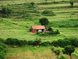
Geography
Valley
In geology, a valley or dale is a depression with predominant extent in one direction. A very deep river valley may be called a canyon or gorge.The terms U-shaped and V-shaped are descriptive terms of geography to characterize the form of valleys...
at the headwaters of the Bhavani River
Bhavani River
The Bhavani is the second largest river in Tamil Nadu, South India and a major tributary of the Kaveri River, the longest river in Tamil Nadu.-Description:...
nestled below the Nilgiri Hills of the Western Ghats
Western Ghats
The Western Ghats, Western Ghauts or the Sahyādri is a mountain range along the western side of India. It runs north to south along the western edge of the Deccan Plateau, and separates the plateau from a narrow coastal plain along the Arabian Sea. The Western Ghats block rainfall to the Deccan...
. It is bordered to the east by Coimbatore district
Coimbatore District
Coimbatore District is one of the more affluent and industrially advanced districts of the state of Tamil Nadu in India. Coimbatore is known as the Manchester of South India. It one of the most industrialized towns of Tamil Nadu. It has the highest GDP among the districts of Tamil Nadu, even ahead...
in Tamilnadu, on the north by the Nilgiris, south by the Palghat taluk and on the west by Karimba
Karimba
Karimba is a small village in the Palakkad district of Kerala State in India.Situated on National Highway 213 between the towns of Palakkad and Mannarkkad, Karimba is well connected to three airports of Kozhikode, Coimbatore and Kochi...
, Pottassery and Mannarghat revenue villages of Mannarghat taluk of the Palghat District and Ernad taluk of the Malappuram district.
The 249 km² Attappadi Reserve Forest is an informal buffer zone
Buffer zone
A buffer zone is generally a zonal area that lies between two or more other areas , but depending on the type of buffer zone, the reason for it may be to segregate regions or to conjoin them....
bordering the Silent Valley National Park
Silent Valley National Park
Silent Valley National Park , is located in the Nilgiri Hills, Palakkad District in Kerala, South India...
to the West. 81 km² of this forest was separated to become most of the new 94 km² Bhavani Forest Range which is part of the 147.22 km² Silent Valley Buffer Zone formally approved by the Kerala Cabinet on 6 June 2007. The Cabinet also sanctioned 35 staff to protect the area and two new forest stations in Bhavani range at Anavai and Thudukki. The zone is aimed at checking the illicit cultivation of ganja, poaching and illicit brewing in areas adjacent to Silent Valley and help long-term sustainability of the protected area.
Elevation
The elevation of a geographic location is its height above a fixed reference point, most commonly a reference geoid, a mathematical model of the Earth's sea level as an equipotential gravitational surface ....
of Attappati valley ranges from 750 metres (2,460.6 ft) to the Malleswaram peak at 11°6′32"N 76°33′8"E which rises to 1664 metres (5,459.3 ft) from the center of the valley. The Bhavani River flows from the Northwest around the mountain in a tight bend past Attappaddi village and continues to the Southeast.
Geology
Gneisses are the predominant rocks in Attappadi. All rock types of Attappadi other than supracrustals could be categorized into seven broad types. They are charnockiteCharnockite
Charnockite is applied to any orthopyroxene-bearing granite, composed mainly of quartz, perthite or antiperthite and orthopyroxene , as an end-member of the charnockite series.-Charnockite series:...
, hornblende gneiss, migmaititic amphibolite, quartz biotite gneiss, quartz-feldspathic gneiss, biotite granite gneiss, and pegmatite
Pegmatite
A pegmatite is a very crystalline, intrusive igneous rock composed of interlocking crystals usually larger than 2.5 cm in size; such rocks are referred to as pegmatitic....
. Among the rock types charnockite, hornblende gneiss, migmatitic amphibolite, quartz biotite gneiss, quartz-feldspathic gneiss, and biotite granite gneiss have been identified that belong to the Peninsular Gneissic Complex. The granite and pegmatite of Attappadi represent the post-kinematic intrusives. Many dolerite dykes also have been reported from this area. The bands and layers of ultramafics and mafic rocks (Ultramafic and mafic rocks represented by metapyroxinite, talc-tremolite-actinolite schist and amphibolites) of varying dimension, BIF, sillimamite/kyanite bearing quartzite and fuchsite quartzite occurring within the Peninsular Gneissic Complex of Attappadi area designated as Attappadi Supracrustals. Remnants and enclaves of Attappadi supracrustals occur within the gneisses. BIF is another important rock type occurring in close association with the metapyroxinite and amphibolites.
Attappadi is unique in that a number of rock types varying in composition from ultramafic to metapelites occur as supracrustals. The metapelites are of granulite facies and the ultramafics are of greenschist facies and the enclosing gneisses represent amphibolites facies.
The area had undergone polyphase deformation. The planar S0, is defined by the layering within chemogenic precipitate (BIF). The earliest folds F1, apart from being tight and appressed occur in intrafolial positions and also constitute the rootless folds. This folding has given rise to an axial planar penetrative foliation and is defined mainly by hornblende and to a lesser extend by chlorite and is co-parallel to the lithoboundaries identified as S0. S1 schistosity is defined by hornblende and chlorite, and this mineralogical association suggests that the deformation occurred under upper greenschist to lower amphibolite facies conditions. The subsequent F2 resulted in refolding of S1 and transposition of S1 subparallel to the F2 axial trace. The most prominent planar structures are the discrete mylonitic foliation S2 attributed the regional NE-SW trending Bhavani shear. Mylonite development, biotitization, chloritization and microgranulation are found associated with these surfaces.
Gold Mineralization
Mani 1965 reported the panning for gold by local miners in Siruvani River of Attappadi. Detailed studies to assess the economic potential of Attappadi area was carried out subsequently by Geological Survey of India. However, no primary gold prospects were identified. Nair 1993 carried out the geomorphologic mapping combined with panning of Siruvani River which led to the discovery of primary gold mineralization in epigenetic quartz vein in Puttumala. The veining, mineralization and associated lithology of this deposit appear to be typical of greenstone-hosted lode gold deposit.On the basis of mode of occurrence two types of gold mineralization are recognized in Attappadi, (1) Primary gold mineralization is associated with quartz veins intruding to AS and PGC. (2) Placer deposit along the bank of Siruvani River.The Geological Survey of India has confirmed the high gold bearing potentiality of the rocks in the 834sq km area of the Attappadi. Gold mineralization is known from Kottathara, Puttumala, Pothupadi, Mundaiyur and Kariyur-Vannathorai Prospects of Attappadi. Gold occurs in quartz veins traversing in BIF, metavolcanics, and hornblende and biotite gneiss. Deccan Gold Mines Limited later confirmed the earlier reported gold grades and have given the following values,
Kottathara prospect: Three zones have been delineated and the prospect has an ore resource of 60,000 tonnes grading 13.63g/t gold according to Geological survey of India. While tracing the NE extension of Kottathara prospect, stringers of quartz analyzing 9 g/t 35 g/t and 49g/t gold have been picked up in stream beds.
Puttumala prospect: A 60 cm sample of vein quartz carrying galena (lead sulfide) from old trenches showed high spot values of gold up to 21g/t.
Pothupadi Prospect: A sample of vein quartz traversing amphibolite assayed 4 g/t gold.
Mundaiyur Prospect: Gold occurs in quartz veins over a length of 300 m with gold-bearing sulphides enveloping the quartz veins.
Kariyur-Vannathorai Prospect: Samples of vein quartz have shown gold contents ranging from 3 to 20 g/t.
In Attappadi region gold grains are found only in native state and occur in different shapes and sizes. Visible specks of gold were noticed in the samples collected from veins, particularly where the associated sulphides have been subjected to weathering and leaching resulting in the formation of limonite. Gold grains with maximum dimension of 2 mm were reported. Pyrite is the dominant sulfide phase within the quartz lodes (occurring as stringers and fracture fillings). Chalcopyrite
Chalcopyrite
Chalcopyrite is a copper iron sulfide mineral that crystallizes in the tetragonal system. It has the chemical composition CuFeS2. It has a brassy to golden yellow color and a hardness of 3.5 to 4 on the Mohs scale. Its streak is diagnostic as green tinged black.On exposure to air, chalcopyrite...
, covellite
Covellite
Covellite is a rare copper sulfide mineral with the formula CuS. This indigo blue mineral is ubiquitous in copper ores, it is found in limited abundance and is not an important ore of copper itself, although it is well known to mineral collectors.The mineral is associated with chalcocite in zones...
, chalcocite
Chalcocite
Chalcocite, copper sulfide , is an important copper ore mineral. It is opaque, being colored dark-gray to black with a metallic luster. It has a hardness of 2½ - 3. It is a sulfide with an orthorhombic crystal system....
, and galena
Galena
Galena is the natural mineral form of lead sulfide. It is the most important lead ore mineral.Galena is one of the most abundant and widely distributed sulfide minerals. It crystallizes in the cubic crystal system often showing octahedral forms...
are commonly observed in the mineral assemblage
Climate
Attapadi RF in the southwest portion of Mannarghat Forest Division receives a high rainfall of 4700 mm (185 in). Moving eastward along the Attapadi valley towards Agali, the rainfall steadily decreases to a low of 900 mm.Population
There are 171 hamlets in Attapadi. The population of the valley is mostly Muduga, IrulaIrulas
Irulas are a scheduled tribe of India. Irulas are present in various parts of India, but are mainly located in the Thiruvallur district of Tamil Nadu...
and Kurumba tribal people
Tribe
A tribe, viewed historically or developmentally, consists of a social group existing before the development of, or outside of, states.Many anthropologists use the term tribal society to refer to societies organized largely on the basis of kinship, especially corporate descent groups .Some theorists...
with a small section of settlers from Tamilnadu and Other Districts of Kerala.
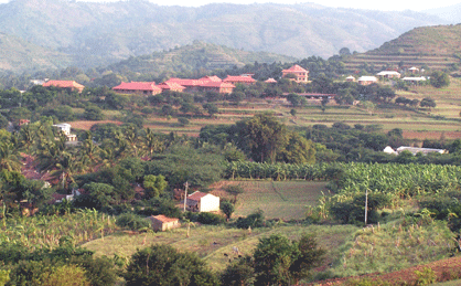
Infrastructure
The local governments of Attappadi are the Agali, Puthur and Sholayur GramaVillage
A village is a clustered human settlement or community, larger than a hamlet with the population ranging from a few hundred to a few thousand , Though often located in rural areas, the term urban village is also applied to certain urban neighbourhoods, such as the West Village in Manhattan, New...
Panchayats.
Health
There are three government primary health centres (PHC), one community health centre (CHC) and 27 subcentres in this 745-km² block. All hamlets are serviced by an effective government health extension program using trained tribal health volunteers. The tribal women of 80 Attapadi hamlets are conducting a vocal campaign against liquor and ganja which has received public support from the Governor. The Society of the Missionaries of St. Thomas operates the St. Thomas Ashram in Nelippathy for providing services to the tribal people of Attapadi including a 15 bed Hospital and health clinic with Lab, X-ray, Dental X-ray, ECG, Pharmacy and ambulance.Education
St Thomas Ashram facilities include a 220 student I – VII standard English medium boarding school.Transportation
There are frequent local buses from Anakkatti village in Attappadi to the nearest town of Nelippathy (16 km) and Mannarghat (38 km).SholayurDevelopment projects
In 1970 the State Planning Board assessed Attappati as the most backward block in the state and the first Integrated Tribal Development Project in Kerala was initiated there. Since then, the state government has implemented several special development projects including the Attappadi Co-operative Farming Society, the Western Ghats Development Programme , the Attappadi Valley Irrigation Programme and the People's Planning Programme implemented in Attappadi in 1997–2002.A monumental palace-like "Bharat Yatra Centre" at Agali was established in 1984 by a former Prime Minister
Prime Minister of India
The Prime Minister of India , as addressed to in the Constitution of India — Prime Minister for the Union, is the chief of government, head of the Council of Ministers and the leader of the majority party in parliament...
, Chandra Shekhar
Chandra Shekhar
Chandra Shekhar Singh was the eighth Prime Minister of India.-Early years:He was born on 1 July 1927 to a Rajput farming family in Ibrahimpatti - Ballia in eastern Uttar Pradesh. Chandra Shekhar Singh did his Master of Arts at Allahabad University. He was known as a firebrand in student politics...
, to provide employment training in weaving, pottery, embroidery and food processing to the women of this rural area. The property was occasionally occupied personally by Chandra Shekar but employment training never happened. The leaders of Girijan Sevak Samaj (GSS), the major tribal body in Attappadi, stated that the center was built on original tribal lands possessed illegally.
In 2000 The Centre at Attappadi and its huge building were deserted and unoccupied.
Many of these projects were not well adapted to traditional adivasi culture and beliefs so about 80 per cent of the tribal population is still living in abject poverty. Attappadi demonstrates how difficult it is for a modern government development process to succeed in a traditional self-sustaining indigenous peoples (adivasi
Adivasi
Adivasi is an umbrella term for a heterogeneous set of ethnic and tribal groups claimed to be the aboriginal population of India. They comprise a substantial indigenous minority of the population of India...
) community. Tribal people are a majority of the Attappadi population but have a high illiteracy rate of 49.5 per cent and a lack of political and administrative awareness. The majority of project managers and new land owners are from other parts of Kerala, Tamil Nadu and other states.
Indian rupee
The Indian rupee is the official currency of the Republic of India. The issuance of the currency is controlled by the Reserve Bank of India....
219 crore
Crore
A crore is a unit in the Indian number system equal to ten million , or 100 lakhs. It is widely used in India, Bangladesh, Nepal, and Pakistan....
($5,000,000) development assistance loan
Official development assistance
Official development assistance is a term compiled by the Development Assistance Committee of the Organisation for Economic Co-operation and Development to measure aid. The DAC first compiled the term in 1969. It is widely used by academics and journalists as a convenient indicator of...
from the Japan Bank for International Cooperation (JBIC) and is implemented by the Attappadi Hills Area Development Society (AHADS), a state government agency. AHADS has made good quantified achievements that will bring long term benefit to the valley.
Attappady Social Service Organisation (ASSO) is one of the major Social Service Organization functioning in Attappady. It successfully implemented World Bank aided 'Jalanidhi' project to provide drinking water facility for the tribal community.
Festival
At the Ayyappan
Ayyappan
Ayyappan is a Hindu deity worshiped in a number of shrines across India. Ayyappan is believed to be an incarnation of Dharma Sastha, who is the son of Shiva and Vishnu . The name "Ayyappan" is used as a respectful form of address in the Malayalam language, spoken in the Indian state of Kerala...
temple in Agali, Ayyappan Vilakku is celebrated in January.