
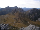
Arthur Range
Encyclopedia
The Arthur Range is a mountain range
Mountain range
A mountain range is a single, large mass consisting of a succession of mountains or narrowly spaced mountain ridges, with or without peaks, closely related in position, direction, formation, and age; a component part of a mountain system or of a mountain chain...
in the South West Wilderness, Tasmania
Tasmania
Tasmania is an Australian island and state. It is south of the continent, separated by Bass Strait. The state includes the island of Tasmania—the 26th largest island in the world—and the surrounding islands. The state has a population of 507,626 , of whom almost half reside in the greater Hobart...
, Australia
Australia
Australia , officially the Commonwealth of Australia, is a country in the Southern Hemisphere comprising the mainland of the Australian continent, the island of Tasmania, and numerous smaller islands in the Indian and Pacific Oceans. It is the world's sixth-largest country by total area...
. The range is broken into two main section, the Western Arthurs and the Eastern Arthurs. Both sections of the range are popular overnight bushwalking
Backpacking (wilderness)
Backpacking combines the activities of hiking and camping for an overnight stay in backcountry wilderness...
destinations, generally in summer.
History
The range was named by George Augustus RobinsonGeorge Augustus Robinson
George Augustus Robinson was a builder and untrained preacher. He was the Chief Protector of Aborigines in Port Phillip District from 1839 to 1849...
who climbed Mount Frederick (now Mount Hayes
Mount Hayes
Mount Hayes is the highest mountain in the eastern Alaska Range. Despite not being a fourteener, it is one of the largest peaks in the United States in terms of rise above local terrain. For example, the Northeast Face rises 8,000 feet in approximately 2 miles...
) in March 1830.
Geology
It is mainly composed of QuartziteQuartzite
Quartzite is a hard metamorphic rock which was originally sandstone. Sandstone is converted into quartzite through heating and pressure usually related to tectonic compression within orogenic belts. Pure quartzite is usually white to gray, though quartzites often occur in various shades of pink...
and features evidence of past glaciation such as moraines and hanging valleys.
Flora/Fauna
Much of the Arthur Range and the area surrounding land is covered by button grass wet sedgelands. Most of the remainder of the land is covered by eucalypt.Birds are the most common animals (e.g. Yellow-tailed Black Cockatoo
Yellow-tailed Black Cockatoo
The Yellow-tailed Black Cockatoo is a large cockatoo native to the south-east of Australia measuring 55–65 cm in length. It has a short crest on the top of its head. Its plumage is mostly brownish black and it has prominent yellow cheek patches and a yellow tail band...
s). In dryer areas, Pademelon
Pademelon
Pademelons are small marsupials of the genus Thylogale. They are usually found in forests. Pademelons are the smallest of the macropods...
s may also be seen.
Climate
The climate in the Arthur Range is extremely unstable - weather predictions are virtually useless here, as it is very common to have sun, heavy rain, cloud, strong winds, even snow all in the same day. The top of the range is classed as Sub-Alpine or Alpine. During winter these mountains are snowcapped. Snow has been experienced every season with regular freak snowfalls during summer, though many of these snowfalls don't settle. The climate is mostly decided by the wind. The temperature can change very quick with warm air from Northern Tasmania, or very cold from the Southern Ocean and Antarctica.Walking
As with other parts of Tasmania's south-west, the trails are extremely muddy — very frequently it is more than ankle deep. The mud does not dissipate with altitude up the mountain range either, except where there is bare rock.Like many other parts of Tasmania, this area is susceptible to Phytophthora
Phytophthora
Phytophthora is a genus of plant-damaging Oomycetes , whose member species are capable of causing enormous economic losses on crops worldwide, as well as environmental damage in natural ecosystems. The genus was first described by Heinrich Anton de Bary in 1875...
(root rot). To avoid spreading it, walkers are encouraged to stay to the main trail. In order to reduce mechanical damage to plants, walkers are also encouraged to wade through the middle of muddy track sections.
Hikers should ensure they are well prepared for any weather conditions, and have enough food for one or two extra days.
Western Arthurs
The Western Arthurs extends generally East West from Mount Hesperus to West Portal. This section of the range was first traversed in the early 1960s.Access to the Western Arthurs is usually from the Scotts peak dam camp site (43°02′15"S 146°17′52"E) via part of the Port Davey Track
Port Davey Track
The Port Davey track in the South Coast Tasmania region is a bushwalking track in the Southwest National Park of Tasmania, Australia.The Port Davey track starts or ends at Melaleuca and runs for 65km north to the Scotts Peak Road...
.
Lakes
The Western Arthurs are studded with many beautiful lakes formed from ice-age glaciers. Among these are:- Lake Oberon (43°08′55"S 146°16′20"E): The subject of a well known photograph by Peter DombrovskisPeter DombrovskisPeter Dombrovskis was an Australian photographer, most notably of Tasmanian scenes. In 2003 he was the only Australian photographer inducted into the International Photography Hall of Fame....
, and where there are camping platforms - Lake Cygnus (43°07′49"S 146°14′16"E): Also has an established camp site
- Lake Ceres (43°08′29"S 146°15′11"E)
- Square Lake (43°08′29"S 146°15′46"E)
- Lake Fortuna (43°07′31"S 146°13′39"E)
Eastern Arthurs
The Eastern Arthurs runs North-South from the end of the Western Arthurs and includes the highest peak of the range, the striking Federation PeakFederation Peak
Federation Peak is a prominent mountain located in the Southwest National Park of Tasmania, Australia. The peak, 90 km from Hobart, was named after the Federation of Australia and is often described as one of the hardest Bushwalking challenges in Australia.-History:The first westerner to...
. This section of the range was first traversed in December 1947 by a group from the Hobart Walking Club.