

Arthur H. Robinson
Encyclopedia
Arthur H. Robinson was an American
geographer
and cartographer, who was professor in the Geography Department at the University of Wisconsin in Madison from 1947 until he retired in 1980. He was a prolific writer and influential philosopher on cartography, and one of his most notable accomplishments is the Robinson projection
in 1961.
, Quebec
, Canada
to American parents. He lived in Great Britain
while he was young, and received his post-secondary education in the United States. His undergraduate
work was done at Miami University
in Oxford, Ohio
, obtaining a B.A. degree in 1936. During his undergraduate work he became especially interested in cartography, and received some practise drawing maps for faculty textbooks while earning a master's degree in geography from the University of Wisconsin–Madison
in 1938, and he earned his Ph.D. degree from the Ohio State University
in 1947. While at Ohio State University
, Robinson worked to solve problems in the Map communication model
.
During World War II
, Robinson served as director of the map division of the Office of Strategic Services
(OSS). In 1941, when Robinson joined OSS, there were no cartographers as we know them today. Robinson engaged geographers with some interest in mapping and the group developed their techniques on the job. Robinson oversaw the creation of 5,000 hand-drawn map
s and attended the Allied
conferences at Quebec
and Cairo
in 1943 and 1944 as chief U.S. map officer. For his efforts Robinson received the Legion of Merit
from the United States Army
in 1946.
In 1947 Robinson subsequently joined the geography department at the University of Wisconsin–Madison
, where he spent his career in academia and research. Robinson sought to establish cartography
as a recognized discipline and ultimately the university granted both undergraduate and masters degrees in cartography. The Wisconsin cartography program has conferred more than 100 masters and 20 doctoral degrees, and many of the doctoral recipients created respected cartography programs at other universities. Today the map library at the University of Wisconsin–Madison
is named in his honor.
Robinson served as president of the International Cartographic Association
, and as vice president and president of the Association of American Geographers
.
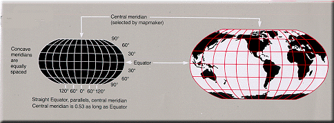 One of Robinson's most notable accomplishments is the Robinson projection
. In 1961, Rand McNally
asked Robinson to choose a projection
for use as a world map that, among other criteria, was uninterrupted, had limited distortion
, and was pleasing to the eye of general viewers. Robinson could not find a projection that satisfied the criteria, so Rand McNally commissioned him to design one.
Robinson proceeded through an iterative process to create a pseudo-cylindrical projection that intends to strike a compromise between distortions in areas and in distances, in order to attain a more natural visualization. The projection has been widely used since its introduction. In 1988, National Geographic adopted it for their world maps but replaced it in 1998 with the Winkel Tripel projection
.
United States
The United States of America is a federal constitutional republic comprising fifty states and a federal district...
geographer
Geographer
A geographer is a scholar whose area of study is geography, the study of Earth's natural environment and human society.Although geographers are historically known as people who make maps, map making is actually the field of study of cartography, a subset of geography...
and cartographer, who was professor in the Geography Department at the University of Wisconsin in Madison from 1947 until he retired in 1980. He was a prolific writer and influential philosopher on cartography, and one of his most notable accomplishments is the Robinson projection
Robinson projection
The Robinson projection is a map projection of a world map, which shows the entire world at once. It was specifically created in an attempt to find a good compromise to the problem of readily showing the whole globe as a flat image....
in 1961.
Biography
Arthur H. Robinson was born in MontrealMontreal
Montreal is a city in Canada. It is the largest city in the province of Quebec, the second-largest city in Canada and the seventh largest in North America...
, Quebec
Quebec
Quebec or is a province in east-central Canada. It is the only Canadian province with a predominantly French-speaking population and the only one whose sole official language is French at the provincial level....
, Canada
Canada
Canada is a North American country consisting of ten provinces and three territories. Located in the northern part of the continent, it extends from the Atlantic Ocean in the east to the Pacific Ocean in the west, and northward into the Arctic Ocean...
to American parents. He lived in Great Britain
Great Britain
Great Britain or Britain is an island situated to the northwest of Continental Europe. It is the ninth largest island in the world, and the largest European island, as well as the largest of the British Isles...
while he was young, and received his post-secondary education in the United States. His undergraduate
Undergraduate education
Undergraduate education is an education level taken prior to gaining a first degree . Hence, in many subjects in many educational systems, undergraduate education is post-secondary education up to the level of a bachelor's degree, such as in the United States, where a university entry level is...
work was done at Miami University
Miami University
Miami University is a coeducational public research university located in Oxford, Ohio, United States. Founded in 1809, it is the 10th oldest public university in the United States and the second oldest university in Ohio, founded four years after Ohio University. In its 2012 edition, U.S...
in Oxford, Ohio
Oxford, Ohio
Oxford is a city in northwestern Butler County, Ohio, United States, in the southwestern portion of the state. It lies in Oxford Township, originally called the College Township. The population was 21,943 at the 2000 census. This college town was founded as a home for Miami University. Oxford...
, obtaining a B.A. degree in 1936. During his undergraduate work he became especially interested in cartography, and received some practise drawing maps for faculty textbooks while earning a master's degree in geography from the University of Wisconsin–Madison
University of Wisconsin–Madison
The University of Wisconsin–Madison is a public research university located in Madison, Wisconsin, United States. Founded in 1848, UW–Madison is the flagship campus of the University of Wisconsin System. It became a land-grant institution in 1866...
in 1938, and he earned his Ph.D. degree from the Ohio State University
Ohio State University
The Ohio State University, commonly referred to as Ohio State, is a public research university located in Columbus, Ohio. It was originally founded in 1870 as a land-grant university and is currently the third largest university campus in the United States...
in 1947. While at Ohio State University
Ohio State University
The Ohio State University, commonly referred to as Ohio State, is a public research university located in Columbus, Ohio. It was originally founded in 1870 as a land-grant university and is currently the third largest university campus in the United States...
, Robinson worked to solve problems in the Map communication model
Map communication model
Map Communication Model is a theory in cartography that characterizes mapping as a process of transmitting geographic information via the map from the cartographer to the end-user.- Overview :...
.
During World War II
World War II
World War II, or the Second World War , was a global conflict lasting from 1939 to 1945, involving most of the world's nations—including all of the great powers—eventually forming two opposing military alliances: the Allies and the Axis...
, Robinson served as director of the map division of the Office of Strategic Services
Office of Strategic Services
The Office of Strategic Services was a United States intelligence agency formed during World War II. It was the wartime intelligence agency, and it was a predecessor of the Central Intelligence Agency...
(OSS). In 1941, when Robinson joined OSS, there were no cartographers as we know them today. Robinson engaged geographers with some interest in mapping and the group developed their techniques on the job. Robinson oversaw the creation of 5,000 hand-drawn map
Map
A map is a visual representation of an area—a symbolic depiction highlighting relationships between elements of that space such as objects, regions, and themes....
s and attended the Allied
Allies of World War II
The Allies of World War II were the countries that opposed the Axis powers during the Second World War . Former Axis states contributing to the Allied victory are not considered Allied states...
conferences at Quebec
Quebec Conference, 1943
The First Quebec Conference was a highly secret military conference held during World War II between the British, Canadian and United States governments. The conference was held in Quebec City, August 17, 1943 – August 24, 1943. It took place at the Citadelle and at the Château Frontenac. The...
and Cairo
Cairo Conference
The Cairo Conference of November 22–26, 1943, held in Cairo, Egypt, addressed the Allied position against Japan during World War II and made decisions about postwar Asia...
in 1943 and 1944 as chief U.S. map officer. For his efforts Robinson received the Legion of Merit
Legion of Merit
The Legion of Merit is a military decoration of the United States armed forces that is awarded for exceptionally meritorious conduct in the performance of outstanding services and achievements...
from the United States Army
United States Army
The United States Army is the main branch of the United States Armed Forces responsible for land-based military operations. It is the largest and oldest established branch of the U.S. military, and is one of seven U.S. uniformed services...
in 1946.
In 1947 Robinson subsequently joined the geography department at the University of Wisconsin–Madison
University of Wisconsin–Madison
The University of Wisconsin–Madison is a public research university located in Madison, Wisconsin, United States. Founded in 1848, UW–Madison is the flagship campus of the University of Wisconsin System. It became a land-grant institution in 1866...
, where he spent his career in academia and research. Robinson sought to establish cartography
Cartography
Cartography is the study and practice of making maps. Combining science, aesthetics, and technique, cartography builds on the premise that reality can be modeled in ways that communicate spatial information effectively.The fundamental problems of traditional cartography are to:*Set the map's...
as a recognized discipline and ultimately the university granted both undergraduate and masters degrees in cartography. The Wisconsin cartography program has conferred more than 100 masters and 20 doctoral degrees, and many of the doctoral recipients created respected cartography programs at other universities. Today the map library at the University of Wisconsin–Madison
University of Wisconsin–Madison
The University of Wisconsin–Madison is a public research university located in Madison, Wisconsin, United States. Founded in 1848, UW–Madison is the flagship campus of the University of Wisconsin System. It became a land-grant institution in 1866...
is named in his honor.
Robinson served as president of the International Cartographic Association
International Cartographic Association
The International Cartographic Association , French Association Cartographique Internationale , is an organization formed of national member organizations, to provide a forum for issues and techniques in cartography...
, and as vice president and president of the Association of American Geographers
Association of American Geographers
The Association of American Geographers is a non-profit scientific and educational society founded in 1904 and aimed at advancing the understanding, study, and importance of geography and related fields...
.
Work
Robinson was a prolific writer and influential philosopher on cartography:- In The Look of Maps (1952) which was based on his Doctoral research, Robinson urged cartographers to consider the function of a map as an integral part of the design process.
- In the text In The Nature of Maps (1976), Robinson and co-author Barbara Bartz Petchenik created the term map percipient,a map user who interacts with a map in a discerning way and not merely as a casual observer. The authors stressed that ...the nature of the map as an image and the manner in which it functions as a communication device between the cartographer and percipient need much deeper consideration and analysis than they have yet received.
- Robinson also co-authored a widely-used textbook, Elements of Cartography, the sixth and last edition of which was published in 1995.
Robinson projection
Robinson projection
The Robinson projection is a map projection of a world map, which shows the entire world at once. It was specifically created in an attempt to find a good compromise to the problem of readily showing the whole globe as a flat image....
. In 1961, Rand McNally
Rand McNally
Rand McNally is an American publisher of maps, atlases, textbooks, and globes for travel, reference, commercial, and educational uses. It also provides online consumer street maps and directions, as well as commercial transportation routing software and mileage data...
asked Robinson to choose a projection
Map projection
A map projection is any method of representing the surface of a sphere or other three-dimensional body on a plane. Map projections are necessary for creating maps. All map projections distort the surface in some fashion...
for use as a world map that, among other criteria, was uninterrupted, had limited distortion
Distortion
A distortion is the alteration of the original shape of an object, image, sound, waveform or other form of information or representation. Distortion is usually unwanted, and often many methods are employed to minimize it in practice...
, and was pleasing to the eye of general viewers. Robinson could not find a projection that satisfied the criteria, so Rand McNally commissioned him to design one.
Robinson proceeded through an iterative process to create a pseudo-cylindrical projection that intends to strike a compromise between distortions in areas and in distances, in order to attain a more natural visualization. The projection has been widely used since its introduction. In 1988, National Geographic adopted it for their world maps but replaced it in 1998 with the Winkel Tripel projection
Winkel tripel projection
The Winkel Tripel projection , a modified azimuthal map projection, is one of three projections proposed by Oswald Winkel in 1921...
.
See also
- Gall–Peters projection
- Rand McNallyRand McNallyRand McNally is an American publisher of maps, atlases, textbooks, and globes for travel, reference, commercial, and educational uses. It also provides online consumer street maps and directions, as well as commercial transportation routing software and mileage data...
- Nicolas Auguste TissotNicolas Auguste TissotNicolas Auguste Tissot was a 19th-century French cartographer, who in 1859 and 1881 published an analysis of the distortion that occurs on map projections. He devised Tissot's indicatrix, or distortion circle, which when plotted on a map will appear as an ellipse whose elongation depends on the...
- David WoodwardDavid WoodwardDavid Woodward was an English-born American historian of cartography and cartographer.- Biography :Woodward was born in Royal Leamington Spa, England. After receiving a bachelor’s degree from the University of Manchester, England, he came to the United States to study cartography under Arthur H....
Publications
Robinson produced over 60 articles for professional publications, as well as fifteen books and monographs. Books:- 1952. The Look of Maps. Madison:University of Wisconsin Press.
- 1976. The Nature of Maps. With B. Petchenik. Chicago: The University of Chicago Press.
- 1982. Early Thematic Mapping in the History of Cartography.
- 1995. Elements of Cartography (6th Edition). With A. Robinson, J. Morrison, P. Muehrke, A. Kimmerling & S. Guptill. New York: Wiley.