

Arai-juku
Encyclopedia
53 Stations of the Tokaido
The are the rest areas along the Tōkaidō, which was a coastal route that ran from Nihonbashi in Edo to Sanjō Ōhashi in Kyoto.-Stations of the Tōkaidō:...
of the Tōkaidō
Tokaido (road)
The ' was the most important of the Five Routes of the Edo period, connecting Edo to Kyoto in Japan. Unlike the inland and less heavily travelled Nakasendō, the Tōkaidō travelled along the sea coast of eastern Honshū, hence the route's name....
. It is located in the city of Kosai
Kosai, Shizuoka
is a city located in far western Shizuoka Prefecture, Japan. As of 2010, the city has an estimated population of 60,582 and a density of 699 persons per km². The total area is 85.65 km².-Geography:...
, Shizuoka Prefecture
Shizuoka Prefecture
is a prefecture of Japan located in the Chūbu region on Honshu island. The capital is the city of Shizuoka.- History :Shizuoka prefecture was formed from the former Tōtōmi, Suruga and Izu provinces.The area was the home of the first Tokugawa Shogun...
, Japan
Japan
Japan is an island nation in East Asia. Located in the Pacific Ocean, it lies to the east of the Sea of Japan, China, North Korea, South Korea and Russia, stretching from the Sea of Okhotsk in the north to the East China Sea and Taiwan in the south...
. During the Edo period
Edo period
The , or , is a division of Japanese history which was ruled by the shoguns of the Tokugawa family, running from 1603 to 1868. The political entity of this period was the Tokugawa shogunate....
, it was located in Tōtōmi Province
Totomi Province
was a province of Japan in the area of Japan that is today western Shizuoka Prefecture. Tōtōmi bordered on Mikawa, Suruga and Shinano Provinces. Its abbreviated form name was .-History:...
. The kanji
Kanji
Kanji are the adopted logographic Chinese characters hanzi that are used in the modern Japanese writing system along with hiragana , katakana , Indo Arabic numerals, and the occasional use of the Latin alphabet...
for the post station
Shukuba
were post stations during the Edo period in Japan, generally located on one of the Edo Five Routes or one of its sub-routes. They were also called shukueki . These post stations were places where travelers could rest on their journey around the nation...
were originally also written as 荒江 and 荒井 (Arai).
History
Arai-juku was located on the western shores of . Travelers crossed the lake to reach Maisaka-jukuMaisaka-juku
was the thirtieth of the fifty-three stations of the Tōkaidō. It is located in the western portion of Hamamatsu in Shizuoka Prefecture, Japan. During the Edo period, the area was part of Tōtōmi Province. The kanji for the post station were originally written 舞坂 .-History:Maisaka-juku was located on...
, the previous post station on the Tōkaidō. Though there were many checkpoints along the Tōkaidō, the Arai Checkpoint is the only one that existed both on land and on the water.
Both the checkpoint and post station were often damaged from earthquakes and tsunami
Tsunami
A tsunami is a series of water waves caused by the displacement of a large volume of a body of water, typically an ocean or a large lake...
, which led to them both being moved to different locations. The current location was established after the earthquake of 1707
1707 Hōei earthquake
The 1707 Hōei earthquake, which occurred at 14:00 local time on October 28, 1707, was the largest in Japanese history until the 2011 Tōhoku earthquake surpassed it. It caused moderate to severe damage throughout southwestern Honshu, Shikoku and southeastern Kyūshū. The earthquake and the resulting...
. The existing checkpoint building was used as a school after the checkpoint was abolished at the start of the Meiji period
Meiji period
The , also known as the Meiji era, is a Japanese era which extended from September 1868 through July 1912. This period represents the first half of the Empire of Japan.- Meiji Restoration and the emperor :...
. It is now preserved as a museum dedicated to the history and culture of the post stations.
The , a preserved still remaining today, served as a rest spot for official travelers coming from Kii Province
Kii Province
, or , was a province of Japan in the part of Honshū that is today Wakayama Prefecture, as well as the southern part of Mie Prefecture. Kii bordered Ise, Izumi, Kawachi, Shima, and Yamato Provinces. The Kii Peninsula takes its name from this province....
further south. It is now a local history museum.
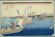
The classic ukiyoe print by Ando Hiroshige (Hoeido edition) from 1831-1834 depicts a daimyo
Daimyo
is a generic term referring to the powerful territorial lords in pre-modern Japan who ruled most of the country from their vast, hereditary land holdings...
procession on sankin kotai
Sankin kotai
was a policy of the shogunate during most of the Edo period of Japanese history. The purpose was to control the daimyo. In adopting the policy, the shogunate was continuing and refining similar policies of Toyotomi Hideyoshi. In 1635, a law required sankin kōtai, which was already an established...
crossing between Maisaka-juku and Arai-juku by boat. The daimyo is in a large vessel with his family crest, while his retainers follow in a smaller boat with the baggage.
Further reading
- Carey, Patrick. Rediscovering the Old Tokaido:In the Footsteps of Hiroshige. Global Books UK (2000). ISBN 1901903109
- Chiba, Reiko. Hiroshige's Tokaido in Prints and Poetry. Tuttle. (1982) ISBN 0804802467
- Taganau, Jilly. The Tokaido Road: Travelling and Representation in Edo and Meiji Japan. RoutledgeCurzon (2004). ISBN 0415310911