
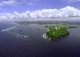
Cabras Island
Encyclopedia
Apra Harbor
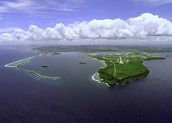
Apra Harbor is a deep-water port on the western side of Guam in the Mariana Islands. The harbor is formed by Orote Peninsula in the south and Cabras Island in the north. To the south, the harbor narrows and then widens again to form an inner harbor. The southern end of the harbor is the location...
, Guam
Guam
Guam is an organized, unincorporated territory of the United States located in the western Pacific Ocean. It is one of five U.S. territories with an established civilian government. Guam is listed as one of 16 Non-Self-Governing Territories by the Special Committee on Decolonization of the United...
.
The island's length has been extended artificially by the Glass Breakwater, named for Captain Glass, who took Guam for the United States in 1898. A road extends to the breakwater, though this is sometimes closed for security reasons during visits by ships.
The opposite coast of the harbor is formed by the Orote Peninsula, culminating in Point Udall
Point Udall (Guam)
Point Udall is the westernmost point in the territorial United States, located on the Orote Peninsula of Guam. It lies at the mouth of Apra Harbor, on the end of Orote Peninsula, opposite the Glass Breakwater of Cabras Island which forms the northern coast of the harbor.-Naming:The point is named...
(formerly Orote Point), mainland Guam's westernmost extremity.