
Angora Fire
Encyclopedia
The Angora Fire was a wind driven fire that started near North Upper Truckee Road subdivision near Angora Lakes
, Fallen Leaf Lake, Echo Lake
and South Lake Tahoe, California
around 2:15 PM on Sunday, June 24, 2007 as a result of an illegal campfire. As of July 2, 2007, the fire was 100% contained, and 100% control (all interior fires extinguished) was achieved on July 10. The fire burned 3,100 acres (12.5 km²), destroyed 242 residences and 67 commercial structures, and damaged 35 other homes. At the peak, there were as many as 2,180 firefighters involved in battling the blaze. As of July 2, there were still 260 personnel fighting the remaining fires in the interior of the containment line. The fire cost $11.7 million to fight.
and the town of Meyers
. During that time, the region was experiencing extremely strong winds
and low relative humidity
, which fanned the fire and created an extremely rapid moving crown fire. Many neighborhoods were evacuated immediately, giving only very short warning to residents, sometimes as short as 5 minutes. In addition to the strong winds, the fire was also fuelled by unusually dry conditions in the Sierra Nevada (U.S.). A study concluded that snow pack was 29% of average in 2007.
After an hour of burning, soot began to fall from the sky around the Tahoe Keys area. People flocked to head towards the source, but the firefighters blockaded the road near the high school. A day after the fire started, the state of California declared it a state of emergency, opening up state funds. Full containment of the fire was announced on July 2, 2007, two days before the 4th of July holiday.
911 calls from cell phones are received by the CHP. Residents in the area as well as golfers on a nearby course made calls that were later found to have not been reported. Investigations were pending as of Friday July 13th.
from loss of vegetation and falling ash will reduce Lake Tahoe's high level clarity, and perhaps feed an ever-increasing algae problem in the lake.
Angora Lakes
The Angora Lakes are two small freshwater lakes in the Sierra Nevada and Lake Tahoe Watershed ~ in elevation above Fallen Leaf Lake and Lake Tahoe. It is the location of the , a small summer outdoor recreation location. The lakes were named for a herd of Angora goats that used to graze in the...
, Fallen Leaf Lake, Echo Lake
Echo Lake, California
Echo Lake is a small unincorporated community in El Dorado County, California, United States, along U.S. Highway 50 in the mountains of the Sierra Nevada. It is north-northwest of Echo Summit. Echo Lake's nearest neighboring town is Little Norway. The ZIP code is 95721. The community is inside...
and South Lake Tahoe, California
South Lake Tahoe, California
South Lake Tahoe is the most populous city in El Dorado County, California, in the Sierra Nevada Mountains. The population was 21,403 at the 2010 census, down from 23,609 at the 2000 census...
around 2:15 PM on Sunday, June 24, 2007 as a result of an illegal campfire. As of July 2, 2007, the fire was 100% contained, and 100% control (all interior fires extinguished) was achieved on July 10. The fire burned 3,100 acres (12.5 km²), destroyed 242 residences and 67 commercial structures, and damaged 35 other homes. At the peak, there were as many as 2,180 firefighters involved in battling the blaze. As of July 2, there were still 260 personnel fighting the remaining fires in the interior of the containment line. The fire cost $11.7 million to fight.
Overview
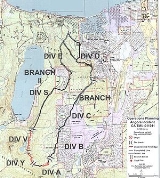
The fire began at approximately 2:15 PM on June 24, 2007 near Seneca Pond, a small lake near Lake TahoeLake Tahoe
Lake Tahoe is a large freshwater lake in the Sierra Nevada of the United States. At a surface elevation of , it is located along the border between California and Nevada, west of Carson City. Lake Tahoe is the largest alpine lake in North America. Its depth is , making it the USA's second-deepest...
and the town of Meyers
Meyers, California
Meyers is a small unincorporated community in El Dorado County, California, United States, along U.S. Route 50 in the foothills of the Sierra Nevada south of South Lake Tahoe in the Lake Tahoe area. It lies at an elevation of 6352 feet...
. During that time, the region was experiencing extremely strong winds
WINDS
WINDS , is a Japanese communication satellite. Launch was originally scheduled for 2007. The launch date was eventually set for 15 February 2008, however a problem detected in a second stage manoeuvring thruster delayed it to 23 February...
and low relative humidity
Relative humidity
Relative humidity is a term used to describe the amount of water vapor in a mixture of air and water vapor. It is defined as the partial pressure of water vapor in the air-water mixture, given as a percentage of the saturated vapor pressure under those conditions...
, which fanned the fire and created an extremely rapid moving crown fire. Many neighborhoods were evacuated immediately, giving only very short warning to residents, sometimes as short as 5 minutes. In addition to the strong winds, the fire was also fuelled by unusually dry conditions in the Sierra Nevada (U.S.). A study concluded that snow pack was 29% of average in 2007.
After an hour of burning, soot began to fall from the sky around the Tahoe Keys area. People flocked to head towards the source, but the firefighters blockaded the road near the high school. A day after the fire started, the state of California declared it a state of emergency, opening up state funds. Full containment of the fire was announced on July 2, 2007, two days before the 4th of July holiday.
Investigation
An investigation into the cause of the fire determined its point of origin. The fire was believed to be human caused, as no thunderstorms were occurring or in the vicinity when the fire began. On 6-29 fire department personnel announced that the cause was an illegal campfire, (or possibly a discarded cigarette into a campfire pit) and further investigation is pending.911 dispatcher controversy
On July 3rd the California Highway Patrol announced investigations into whether 911 dispatchers failed to notify authorities about numerous calls that began coming into them about the Angora Fire. A number of calls that were received about the fire were disregarded by dispatchers who claimed that the fire was a controlled burn.911 calls from cell phones are received by the CHP. Residents in the area as well as golfers on a nearby course made calls that were later found to have not been reported. Investigations were pending as of Friday July 13th.
Effects
As of June 28, over $141 million in damage had occurred. 254 homes destroyed, 26 homes damaged and 3,000 evacuations were prompted, making it among the top half-dozen most costly fires in the U.S. As of June 28 the cost to fight the fire has been estimated at $10 million, with $5.5 million spend so far. FEMA will pay 75%. Losses to the tourist-driven economy are estimated/forecast to be around $1 billion. Increased erosionErosion
Erosion is when materials are removed from the surface and changed into something else. It only works by hydraulic actions and transport of solids in the natural environment, and leads to the deposition of these materials elsewhere...
from loss of vegetation and falling ash will reduce Lake Tahoe's high level clarity, and perhaps feed an ever-increasing algae problem in the lake.
Aftermath
Because the fire occurred in the watershed of Lake Tahoe, one of the primary concerns once the fire was out was the potential impact of the ash and debris on the Lake Tahoe hydrological system. Of major concern was the potentially hazardous debris from the 256 structures that were burned in the fire. To address this, the Governor issued Executive Order S-09-07 which initiated a major debris removal project to remove the structural debris as quickly and safely as possible from the 250+ private properties affected by the fire. The debris removal was operationally conducted by the California Integrated Waste Management Board on behalf of El Dorado County. Debris removal activities commenced on July 12, 2007 and was completed by the end of August. Work continues on erosion control measures and removal of potentially hazardous trees. No significant long-term ecological damage is believed to have occurred.External links
- Inciweb for Angora Fire
- California Department of Forestry & Fire Protection for Angora Fire
- Firefighter Blog Coverage
- Ongoing coverage and photo gallery Sacramento Bee
- Photo gallery of fire KOLOTV.com, Reno, Nevada
- Google Earth Tour of fire damage showing destroyed homes
- California Integrated Waste Management Board - Angora Fire
- Map of Angora Fire and origin at Seneca Pond - SFGate.com, June 28, 2007