
Andover, New Hampshire
Encyclopedia
Andover is a town in Merrimack County
, New Hampshire
, United States
. The population was 2,371 at the 2010 census. Andover includes the villages of Cilleyville, Potter Place, and East Andover
, in addition to the town center. The town is home to Ragged Mountain
State Forest and Proctor Academy
, a private coeducational preparatory school
.
during hostilities with the French
in Canada
. Among those soldiers was their regimental surgeon, Dr. Anthony Emery, a friend of Samuel Phillips, Jr.
, who in 1778 founded the Phillips Andover Academy
in Andover
, Massachusetts
. "New Breton" would be incorporated as "Andover" in 1779, the year Phillips Andover was completed.
 In 1822, an academy was established in Andover, although it would close in 1828. Another school was founded in 1848 that would become Proctor Academy, the prestigious institution around which the town's economy is based. Andover is noted for its antique shop
s, Greek Revival architecture
, and two covered bridge
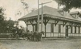
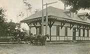
s. Potter Place Railroad Station, built in 1874 by the Northern Railroad, is listed on the National Register of Historic Places
, and today serves as a museum for the Andover Historical Society.
, the town has a total area of 41.3 square miles (107 km²), of which 40.5 sq mi (104.9 km²) is land and 0.9 sq mi (2.3 km²) is water, comprising 2.11% of the town. Andover is drained by the Blackwater River
. Bradley Lake is in the south. Ragged Mountain
, elevation 2286 feet (696.8 m) above sea level
, is on the northern boundary. The northern slopes of Mount Kearsarge occupy the southernmost part of town and contain the town's highest point, 2460 ft (749.8 m) above sea level. Andover lies fully within the Merrimack River
watershed
.
Andover includes the villages of East Andover, West Andover, Cilleyville, and Potter Place, named for Richard Potter
, an African-American illusionist
who lived there in the early 19th century.
 As of the census
of 2000, there were 2,109 people, 823 households, and 609 families residing in the town. The population density
was 52.1 people per square mile (20.1/km²). There were 1,038 housing units at an average density of 25.7 per square mile (9.9/km²). The racial makeup of the town was 98.20% White, 0.38% African American, 0.14% Native American, 0.05% Asian, 0.05% Pacific Islander, 0.05% from other races, and 1.14% from two or more races. Hispanic or Latino of any race were 0.19% of the population.
There were 823 households out of which 33.7% had children under the age of 18 living with them, 61.7% were married couples
living together, 7.7% had a female householder with no husband present, and 26.0% were non-families. 20.5% of all households were made up of individuals and 7.4% had someone living alone who was 65 years of age or older. The average household size was 2.55 and the average family size was 2.90.
 In the town the population was spread out with 24.3% under the age of 18, 6.2% from 18 to 24, 28.2% from 25 to 44, 28.6% from 45 to 64, and 12.7% who were 65 years of age or older. The median age was 40 years. For every 100 females there were 100.5 males. For every 100 females age 18 and over, there were 98.8 males.
The median income for a household in the town was $47,093, and the median income for a family was $52,212. Males had a median income of $33,074 versus $25,927 for females. The per capita income
for the town was $21,627. About 4.5% of families and 5.7% of the population were below the poverty line
, including 7.6% of those under age 18 and 6.3% of those age 65 or over.
Merrimack County, New Hampshire
-Demographics:As of the census of 2000, there were 136,225 people, 51,843 households, and 35,460 families residing in the county. The population density was 146 people per square mile . There were 56,244 housing units at an average density of 60 per square mile...
, New Hampshire
New Hampshire
New Hampshire is a state in the New England region of the northeastern United States of America. The state was named after the southern English county of Hampshire. It is bordered by Massachusetts to the south, Vermont to the west, Maine and the Atlantic Ocean to the east, and the Canadian...
, United States
United States
The United States of America is a federal constitutional republic comprising fifty states and a federal district...
. The population was 2,371 at the 2010 census. Andover includes the villages of Cilleyville, Potter Place, and East Andover
East Andover, New Hampshire
East Andover is an unincorporated village in the town of Andover in Merrimack County, New Hampshire.The village is located on the east shore of Highland Lake, along New Hampshire Route 11 in the eastern portion of Andover. Route 11 runs east to Franklin and New Hampshire's Lakes Region, and runs...
, in addition to the town center. The town is home to Ragged Mountain
Ragged Mountain (New Hampshire)
Ragged Mountain is a low mountain with numerous knobby summits in the towns of Danbury and Andover in central New Hampshire. It is home to the Ragged Mountain ski resort.-Geography:In his book, The History of the Town of Andover, John R...
State Forest and Proctor Academy
Proctor Academy
Proctor Academy is a coeducational, independent preparatory boarding school for grades 9-12 located on in Andover, New Hampshire.-Origin:Andover Academy was established in 1848 by the Town of Andover. The idea of the school spawned from a sewing group conversation between the wives of the area's...
, a private coeducational preparatory school
University-preparatory school
A university-preparatory school or college-preparatory school is a secondary school, usually private, designed to prepare students for a college or university education...
.
History
Settled in 1761, the town was originally named "New Breton," having been granted primarily to soldiers who had taken part in the 1745 capture of Cape BretonCape Breton Island
Cape Breton Island is an island on the Atlantic coast of North America. It likely corresponds to the word Breton, the French demonym for Brittany....
during hostilities with the French
France
The French Republic , The French Republic , The French Republic , (commonly known as France , is a unitary semi-presidential republic in Western Europe with several overseas territories and islands located on other continents and in the Indian, Pacific, and Atlantic oceans. Metropolitan France...
in Canada
Canada
Canada is a North American country consisting of ten provinces and three territories. Located in the northern part of the continent, it extends from the Atlantic Ocean in the east to the Pacific Ocean in the west, and northward into the Arctic Ocean...
. Among those soldiers was their regimental surgeon, Dr. Anthony Emery, a friend of Samuel Phillips, Jr.
Samuel Phillips, Jr.
Samuel Phillips, Jr. . Merchant, manufacturer and patriot, Phillips is considered a pioneer in American education.Samuel Phillips Jr. was born in North Andover, Massachusetts...
, who in 1778 founded the Phillips Andover Academy
Phillips Academy
Phillips Academy is a selective, co-educational independent boarding high school for boarding and day students in grades 9–12, along with a post-graduate year...
in Andover
Andover, Massachusetts
Andover is a town in Essex County, Massachusetts, United States. It was incorporated in 1646 and as of the 2010 census, the population was 33,201...
, Massachusetts
Massachusetts
The Commonwealth of Massachusetts is a state in the New England region of the northeastern United States of America. It is bordered by Rhode Island and Connecticut to the south, New York to the west, and Vermont and New Hampshire to the north; at its east lies the Atlantic Ocean. As of the 2010...
. "New Breton" would be incorporated as "Andover" in 1779, the year Phillips Andover was completed.
Antique shop
An antique shop is a retail store specializing in the selling of antiques. Antiques shops can be located either locally and with the advent of the Internet found online...
s, Greek Revival architecture
Greek Revival architecture
The Greek Revival was an architectural movement of the late 18th and early 19th centuries, predominantly in Northern Europe and the United States. A product of Hellenism, it may be looked upon as the last phase in the development of Neoclassical architecture...
, and two covered bridge
Covered bridge
A covered bridge is a bridge with enclosed sides and a roof, often accommodating only a single lane of traffic. Most covered bridges are wooden; some newer ones are concrete or metal with glass sides...
s. Potter Place Railroad Station, built in 1874 by the Northern Railroad, is listed on the National Register of Historic Places
National Register of Historic Places
The National Register of Historic Places is the United States government's official list of districts, sites, buildings, structures, and objects deemed worthy of preservation...
, and today serves as a museum for the Andover Historical Society.
Geography
According to the United States Census BureauUnited States Census Bureau
The United States Census Bureau is the government agency that is responsible for the United States Census. It also gathers other national demographic and economic data...
, the town has a total area of 41.3 square miles (107 km²), of which 40.5 sq mi (104.9 km²) is land and 0.9 sq mi (2.3 km²) is water, comprising 2.11% of the town. Andover is drained by the Blackwater River
Blackwater River (Contoocook River)
The Blackwater River is a river located in central New Hampshire in the United States. It is a tributary of the Contoocook River, part of the Merrimack River watershed....
. Bradley Lake is in the south. Ragged Mountain
Ragged Mountain (New Hampshire)
Ragged Mountain is a low mountain with numerous knobby summits in the towns of Danbury and Andover in central New Hampshire. It is home to the Ragged Mountain ski resort.-Geography:In his book, The History of the Town of Andover, John R...
, elevation 2286 feet (696.8 m) above sea level
Sea level
Mean sea level is a measure of the average height of the ocean's surface ; used as a standard in reckoning land elevation...
, is on the northern boundary. The northern slopes of Mount Kearsarge occupy the southernmost part of town and contain the town's highest point, 2460 ft (749.8 m) above sea level. Andover lies fully within the Merrimack River
Merrimack River
The Merrimack River is a river in the northeastern United States. It rises at the confluence of the Pemigewasset and Winnipesaukee rivers in Franklin, New Hampshire, flows southward into Massachusetts, and then flows northeast until it empties into the Atlantic Ocean at Newburyport...
watershed
Drainage basin
A drainage basin is an extent or an area of land where surface water from rain and melting snow or ice converges to a single point, usually the exit of the basin, where the waters join another waterbody, such as a river, lake, reservoir, estuary, wetland, sea, or ocean...
.
Andover includes the villages of East Andover, West Andover, Cilleyville, and Potter Place, named for Richard Potter
Richard Potter (magician)
Richard Potter was a magician, hypnotist and ventriloquist. Potter was born in Boston; his father was a British tax collector and his mother a black servant. He became a well-known magician in the New England area. He eventually performed up and down the east coast, going as far south as Alabama....
, an African-American illusionist
Magic (illusion)
Magic is a performing art that entertains audiences by staging tricks or creating illusions of seemingly impossible or supernatural feats using natural means...
who lived there in the early 19th century.
Demographics
Census
A census is the procedure of systematically acquiring and recording information about the members of a given population. It is a regularly occurring and official count of a particular population. The term is used mostly in connection with national population and housing censuses; other common...
of 2000, there were 2,109 people, 823 households, and 609 families residing in the town. The population density
Population density
Population density is a measurement of population per unit area or unit volume. It is frequently applied to living organisms, and particularly to humans...
was 52.1 people per square mile (20.1/km²). There were 1,038 housing units at an average density of 25.7 per square mile (9.9/km²). The racial makeup of the town was 98.20% White, 0.38% African American, 0.14% Native American, 0.05% Asian, 0.05% Pacific Islander, 0.05% from other races, and 1.14% from two or more races. Hispanic or Latino of any race were 0.19% of the population.
There were 823 households out of which 33.7% had children under the age of 18 living with them, 61.7% were married couples
Marriage
Marriage is a social union or legal contract between people that creates kinship. It is an institution in which interpersonal relationships, usually intimate and sexual, are acknowledged in a variety of ways, depending on the culture or subculture in which it is found...
living together, 7.7% had a female householder with no husband present, and 26.0% were non-families. 20.5% of all households were made up of individuals and 7.4% had someone living alone who was 65 years of age or older. The average household size was 2.55 and the average family size was 2.90.
The median income for a household in the town was $47,093, and the median income for a family was $52,212. Males had a median income of $33,074 versus $25,927 for females. The per capita income
Per capita income
Per capita income or income per person is a measure of mean income within an economic aggregate, such as a country or city. It is calculated by taking a measure of all sources of income in the aggregate and dividing it by the total population...
for the town was $21,627. About 4.5% of families and 5.7% of the population were below the poverty line
Poverty threshold
The poverty threshold, or poverty line, is the minimum level of income deemed necessary to achieve an adequate standard of living in a given country...
, including 7.6% of those under age 18 and 6.3% of those age 65 or over.
Notable people
- Nahum Josiah Bachelder (1854–1934), 49th governor of New Hampshire
- Jacob Bailey MooreJacob Bailey MooreJacob Bailey Moore was an American journalist and historical writer.-Ancestors:His ancestors emigrated to the United States from Scotland. His father, who had the same name, was a physician...
(1797–1853), newspaper editor, founder and first librarian of New Hampshire Historical Society