
Amphoe Wiang Sa, Surat Thani Province
Encyclopedia
Wiang Sa is a district (amphoe
) of Surat Thani Province
, Thailand
.
, Khian Sa
and Ban Na San
of Surat Thani, and Phipun
, Chawang
and Tham Phannara
of Nakhon Si Thammarat Province
.
The Tapi River
forms the western boundary of the district. Smaller rivers within the district are Khlong Nam Thao, Khlong Tan and Khlong Chanuan. While to the west the terrain descend to the Tapi plain, to the east are the hills of the Nakhon Si Thammarat mountain range
.
The northeast of the district is protected within the Tai Rom Yen National Park
.
) under the control of Nakhon Si Thammarat
after the Srivijaya
times. This was converted into a district named Khlong Tan (คลองตาล) during the thesaphiban reforms at the end of the 19th century.
However shortly thereafter, in 1896 Wiang Sa was reduced to a tambon within the district Lamphun, the current Ban Na San district
. On March 10 1968 Wiang Sa became a minor district (King Amphoe) by splitting off the tambon Wiang Sa and Thung Luang from Ban Na San district. On November 17 1971 it was upgraded to full district status.
), which are further subdivided into 64 villages (muban
). There are three townships (thesaban tambon) - Wiang Sa covering parts of the tambon Wiang Sa and Ban Song, Ban Song covering the remaining parts of tambon Ban Song, and Khao Niphan covering the complete tambon Khao Nipham. The three tambon which are not completely covered by municipal area each have a Tambon administrative organization (TAO).
Amphoe
An amphoe is the second level administrative subdivision of Thailand. Usually translated as district, amphoe make up the provinces, and are analogous to a county seat...
) of Surat Thani Province
Surat Thani Province
Surat Thani is the largest of the southern provinces of Thailand, on the eastern shore of the Gulf of Thailand. Surat Thani means City of Good People, the title given to the city by King Vajiravudh ....
, Thailand
Thailand
Thailand , officially the Kingdom of Thailand , formerly known as Siam , is a country located at the centre of the Indochina peninsula and Southeast Asia. It is bordered to the north by Burma and Laos, to the east by Laos and Cambodia, to the south by the Gulf of Thailand and Malaysia, and to the...
.
Geography
Wiang Sa is located in the southeast of Surat Thani province. Neighboring district are (from the west clockwise) PhrasaengAmphoe Phrasaeng
-Geography:The district is located in the south of the province. Neighboring districts are Phanom, Khian Sa, Wiang Sa of Surat Thani Province, Tham Phannara, Thung Yai of Nakhon Si Thammarat Province, Chai Buri of Surat Thani Province again, Khao Phanom and Plai Phraya of Krabi Province.At the...
, Khian Sa
Amphoe Khian Sa
Khian Sa is a district in Surat Thani Province, Thailand.Neighboring districts are Khiri Rat Nikhom, Phunphin, Ban Na Doem, Ban Na San, Wiang Sa, Phrasaeng and Phanom...
and Ban Na San
Amphoe Ban Na San
-Geography:Neighboring districts are Nopphitam and Phipun of Nakhon Si Thammarat Province, Wiang Sa, Khian Sa, Ban Na Doem, Mueang Surat Thani and Kanchanadit....
of Surat Thani, and Phipun
Amphoe Phipun
Phipun is a district in the northern part of Nakhon Si Thammarat Province, southern Thailand.-Geography:Neighboring districts are Nopphitam, Phrom Khiri, Lan Saka, Chawang of Nakhon Si Thammarat Province, Wiang Sa and Ban Na San of Surat Thani Province.-History:The minor district was created on...
, Chawang
Amphoe Chawang
Chawang is a district of Nakhon Si Thammarat Province, southern Thailand.-Geography:Neighboring districts are Phipun, Lan Saka, Chang Klang, Na Bon, Thung Yai and Tham Phannara of Nakhon Si Thammarat, and Wiang Sa of Surat Thani Province.The east of the district is part of the Khao Luang...
and Tham Phannara
Amphoe Tham Phannara
Tham Phannara is a district of Nakhon Si Thammarat Province, southern Thailand.-Geography:Neighboring districts are Chawang and Thung Yai of Nakhon Si Thammarat, and Phrasaeng and Wiang Sa of Surat Thani Province....
of Nakhon Si Thammarat Province
Nakhon Si Thammarat Province
Nakhon Si Thammarat is one of the southern provinces of Thailand, at the eastern shore of the Gulf of Thailand...
.
The Tapi River
Tapi River, Thailand
The Tapi river is the longest river in southern Thailand. The river originates at the Khao Luang, and has a wide estuary into the Gulf of Thailand at Bandon Bay near the town of Surat Thani. It has a length of 230 km....
forms the western boundary of the district. Smaller rivers within the district are Khlong Nam Thao, Khlong Tan and Khlong Chanuan. While to the west the terrain descend to the Tapi plain, to the east are the hills of the Nakhon Si Thammarat mountain range
Nakhon Si Thammarat mountain range
The Nakhon Si Thammarat mountain range is a mountain range on the Malay peninsula in southern Thailand, running in a north-south direction. This mountain chain is also sometimes named Banthat mountain range , a name which is however also used to refer to the Chanthaburi mountain...
.
The northeast of the district is protected within the Tai Rom Yen National Park
Tai Rom Yen National Park
The Tai Rom Yen National Park is located in the east of the Surat Thani Province in Southern Thailand. The park consists of the northern end of the Nakhon Si Thammarat mountain range and is mostly covered with forests...
.
History
Wiang Sa originated as a minor city-state (MueangMueang
Mueang were historical semi-independent city-states or principalities in present-day Thailand, Laos, parts of northern Vietnam and the Shan State of Myanmar. Smaller Mueang were subordinate to more powerful neighboring Mueang, which in turn were subordinate to the central king, as described in...
) under the control of Nakhon Si Thammarat
Nakhon Si Thammarat kingdom
Nakhon Si Thammarat Kingdom was one of the major constituent city states of the Siamese kingdoms of Sukhothai and later Ayutthaya and controlled a big part of the Malay peninsula...
after the Srivijaya
Srivijaya
Srivijaya was a powerful ancient thalassocratic Malay empire based on the island of Sumatra, modern day Indonesia, which influenced much of Southeast Asia. The earliest solid proof of its existence dates from the 7th century; a Chinese monk, I-Tsing, wrote that he visited Srivijaya in 671 for 6...
times. This was converted into a district named Khlong Tan (คลองตาล) during the thesaphiban reforms at the end of the 19th century.
However shortly thereafter, in 1896 Wiang Sa was reduced to a tambon within the district Lamphun, the current Ban Na San district
Amphoe Ban Na San
-Geography:Neighboring districts are Nopphitam and Phipun of Nakhon Si Thammarat Province, Wiang Sa, Khian Sa, Ban Na Doem, Mueang Surat Thani and Kanchanadit....
. On March 10 1968 Wiang Sa became a minor district (King Amphoe) by splitting off the tambon Wiang Sa and Thung Luang from Ban Na San district. On November 17 1971 it was upgraded to full district status.
Administration
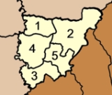
Wiang Sa is subdivided into 5 subdistricts (tambonTambon
Tambon is a local government unit in Thailand. Below district and province , they form the third administrative subdivision level. As of the 2009 there are 7255 tambon, not including the 169 khwaeng of Bangkok, which are set at the same administrative level, thus every district contains 8-10 tambon...
), which are further subdivided into 64 villages (muban
Muban
Muban is the lowest administrative subdivision of Thailand. Usually translated as village, they are the subdivision of tambon. As of 2008, there are 74944 administrative villages in Thailand. As of the 1990 census, the average village consisted of 144 households or 746 persons.A muban does not...
). There are three townships (thesaban tambon) - Wiang Sa covering parts of the tambon Wiang Sa and Ban Song, Ban Song covering the remaining parts of tambon Ban Song, and Khao Niphan covering the complete tambon Khao Nipham. The three tambon which are not completely covered by municipal area each have a Tambon administrative organization (TAO).
|
 |