
Amphoe Mueang Songkhla
Encyclopedia
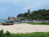
Mueang Songkhla is the capital district (Amphoe Mueang) of Songkhla Province
, southern Thailand
.
 Neighboring districts are (from the south clockwise) Chana
, Na Mom
, Hat Yai
and Singhanakhon
of Songkhla Province. To the east is the Gulf of Thailand
.
The northern part of the district is the Songkhla Lake
.
corruption of Singgora, its original name means 'the city of lion
s' in Malay
. This refers to a lion-shaped mountain near the city of Songkhla.
), which are further subdivided into 46 villages (muban
). The city (thesaban nakhon) Songkhla
covers the whole tambon Bo Yang. There are further 5 Tambon administrative organizations (TAO).
Songkhla Province
Songkhla is one of the southern provinces of Thailand. Neighboring provinces are Satun, Phatthalung, Nakhon Si Thammarat, Pattani and Yala. To the south it borders Kedah and Perlis of Malaysia....
, southern Thailand
Thailand
Thailand , officially the Kingdom of Thailand , formerly known as Siam , is a country located at the centre of the Indochina peninsula and Southeast Asia. It is bordered to the north by Burma and Laos, to the east by Laos and Cambodia, to the south by the Gulf of Thailand and Malaysia, and to the...
.
Geography
Amphoe Chana
Chana is a district in the southeastern part of Songkhla Province, southern Thailand.-Geography:Neighboring districts are Thepha, Na Thawi, Sadao, Hat Yai, Na Mom and Mueang Songkhla of Songkhla Province...
, Na Mom
Amphoe Na Mom
-History:The district was at first the tambon Thung Phra Khian of Hat Yai district, which was changed into tambon Na Mom in 1943. On April 30 1981 it was made the minor district Na Mom, together with three further tambon from Hat Yai district...
, Hat Yai
Amphoe Hat Yai
-Geography:Neighboring districts are Khuan Kalong of Satun Province, and Rattaphum, Bang Klam, Khuan Niang, Singhanakhon, Mueang Songkhla, Na Mom, Chana, Sadao and Khlong Hoi Khong....
and Singhanakhon
Amphoe Singhanakhon
Singhanakhon is a district in the northern part of Songkhla Province, southern Thailand.-Geography:Neighboring districts are Mueang Songkhla, Hat Yai, Khuan Niang of Songkhla Province, Pak Phayun of Phatthalung Province and Sathing Phra of Songkhla Province again...
of Songkhla Province. To the east is the Gulf of Thailand
Gulf of Thailand
The Gulf of Thailand , also known in to Malays as Teluk Siam literally meant Gulf of Siam, is a shallow arm of the South China Sea.-Geography:...
.
The northern part of the district is the Songkhla Lake
Songkhla Lake
The Songkhla lake is the largest natural lake in Thailand, located on the Malay peninsula in the southern part of the country. Covering an area of 1,040 km² it borders the provinces of Songkhla and Phatthalung. Despite being called a lake, this water surface is actually a lagoon complex...
.
History
The name Songkhla is actually the ThaiThai language
Thai , also known as Central Thai and Siamese, is the national and official language of Thailand and the native language of the Thai people, Thailand's dominant ethnic group. Thai is a member of the Tai group of the Tai–Kadai language family. Historical linguists have been unable to definitively...
corruption of Singgora, its original name means 'the city of lion
Lion
The lion is one of the four big cats in the genus Panthera, and a member of the family Felidae. With some males exceeding 250 kg in weight, it is the second-largest living cat after the tiger...
s' in Malay
Malay language
Malay is a major language of the Austronesian family. It is the official language of Malaysia , Indonesia , Brunei and Singapore...
. This refers to a lion-shaped mountain near the city of Songkhla.
Administration
The district is subdivided into 6 subdistricts (tambonTambon
Tambon is a local government unit in Thailand. Below district and province , they form the third administrative subdivision level. As of the 2009 there are 7255 tambon, not including the 169 khwaeng of Bangkok, which are set at the same administrative level, thus every district contains 8-10 tambon...
), which are further subdivided into 46 villages (muban
Muban
Muban is the lowest administrative subdivision of Thailand. Usually translated as village, they are the subdivision of tambon. As of 2008, there are 74944 administrative villages in Thailand. As of the 1990 census, the average village consisted of 144 households or 746 persons.A muban does not...
). The city (thesaban nakhon) Songkhla
Songkhla
Songkhla is a city in the Songkhla Province of southern Thailand, near the border with Malaysia. As of 2006 it had a population of 75,048...
covers the whole tambon Bo Yang. There are further 5 Tambon administrative organizations (TAO).
| No. | Name | Thai name | Villages | Inh. Population A population is all the organisms that both belong to the same group or species and live in the same geographical area. The area that is used to define a sexual population is such that inter-breeding is possible between any pair within the area and more probable than cross-breeding with individuals... |
|
|---|---|---|---|---|---|
| 1. | Bo Yang | บ่อยาง | |||
| 74,875 | |||||
| 2. | Khao Rup Chang | เขารูปช้าง | 10 | 38,662 | |
| 3. | Ko Taeo | เกาะแต้ว | 9 | 10,608 | |
| 4. | Phawong | พะวง | 8 | 24,130 | |
| 5. | Thung Wang | ทุ่งหวัง | 10 | 10,343 | |
| 6. | Ko Yo | เกาะยอ | 9 | 4,454 |