

Amphoe Mae Ai
Encyclopedia
Mae Ai is the northernmost district (amphoe
) of Chiang Mai Province
, northern Thailand
.
. It was official upgraded to a full district on June 28, 1973.
 Neighboring districts are (from the southwest clockwise) Fang
of Chiang Mai Province, Shan State
of Myanmar
, Mae Fa Luang
, Mueang Chiang Rai
and Mae Suai
of Chiang Rai Province
.
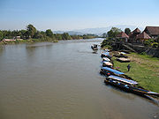
The important rivers are the Kok
and Fang river.
), which are further subdivided into 110 villages (muban
). Mai Ai is also a township (thesaban tambon), which covers parts of the tambon Mae Ai and Malika. There are further 6 Tambon administrative organizations (TAO).
Amphoe
An amphoe is the second level administrative subdivision of Thailand. Usually translated as district, amphoe make up the provinces, and are analogous to a county seat...
) of Chiang Mai Province
Chiang Mai Province
Chiang Mai is the second-largest province of Thailand, located in the north of the country. Neighboring provinces are Chiang Rai, Lampang, Lamphun, Tak, and Mae Hong Son. In the north it borders Shan State of Burma...
, northern Thailand
Thailand
Thailand , officially the Kingdom of Thailand , formerly known as Siam , is a country located at the centre of the Indochina peninsula and Southeast Asia. It is bordered to the north by Burma and Laos, to the east by Laos and Cambodia, to the south by the Gulf of Thailand and Malaysia, and to the...
.
History
The minor district (King Amphoe) Mae Ai was created on August 15, 1967, when the three tambon Mae Ai, Mae Sao and Mae Na Wang were separated from Fang districtAmphoe Fang
Fang is a district in the northern part of Chiang Mai Province, northern Thailand.-History:According to the Yonok chronicle, Mueang Fang was built in 641 by King Lawa Changkarat. Later King Mengrai the Great reigned Fang before building Wiang Kumkam and Chiang Mai of Lanna Kingdom for one year...
. It was official upgraded to a full district on June 28, 1973.
Geography
Amphoe Fang
Fang is a district in the northern part of Chiang Mai Province, northern Thailand.-History:According to the Yonok chronicle, Mueang Fang was built in 641 by King Lawa Changkarat. Later King Mengrai the Great reigned Fang before building Wiang Kumkam and Chiang Mai of Lanna Kingdom for one year...
of Chiang Mai Province, Shan State
Shan State
Shan State is a state of Burma . Shan State borders China to the north, Laos to the east, and Thailand to the south, and five administrative divisions of Burma in the west. Largest of the 14 administrative divisions by land area, Shan State covers 155,800 km², almost a quarter of the total...
of Myanmar
Myanmar
Burma , officially the Republic of the Union of Myanmar , is a country in Southeast Asia. Burma is bordered by China on the northeast, Laos on the east, Thailand on the southeast, Bangladesh on the west, India on the northwest, the Bay of Bengal to the southwest, and the Andaman Sea on the south....
, Mae Fa Luang
Amphoe Mae Fa Luang
Mae Fa Luang is a district in the northern part of Chiang Rai Province, northern Thailand.-History:The area of Mae Fa Luang was separated from Mae Chan district and created as a minor district on April 1, 1992. Originally it comprised the three tambon Thoet Thai, Mae Salong Nai and Mae Salong Nok...
, Mueang Chiang Rai
Amphoe Mueang Chiang Rai
Mueang Chiang Rai is the capital district of Chiang Rai Province, northern Thailand.-Geography:Neighboring districts are Mae Fa Luang, Mae Chan, Wiang Chiang Rung, Wiang Chai, Thoeng, Pa Daet, Phan, Mae Lao, Mae Suai of Chiang Rai Province and Mae Ai of Chiang Mai Province.The important water...
and Mae Suai
Amphoe Mae Suai
Mae Suai is a district in the western part of Chiang Rai Province, northern Thailand.-Geography:Neighboring districts are Mueang Chiang Rai, Mae Lao, Phan, Wiang Pa Pao, Phrao, Chai Prakan, Fang, Mae Ai of Chiang Mai Province.-History:The district was created in 1905, when the districts Mueang...
of Chiang Rai Province
Chiang Rai Province
Chiang Rai is the northernmost province of Thailand. Neighbouring provinces are Phayao, Lampang and Chiang Mai. In the north it borders Shan State of Myanmar and Bokeo of Laos.-Geography:...
.
The important rivers are the Kok
Kok River
The Kok River originates in Shan State, Burma. It flows down and across the Burma-Thailand border to Mae Ai district, Chiang Mai Province, passing under Phahonyothin Road. Most of its length is in Chiang Rai Province passing the districts Mueang Chiang Rai, Mae Chan, Chiang Saen and Wiang Chai. It...
and Fang river.
Administration
The district is subdivided into 7 communes (tambonTambon
Tambon is a local government unit in Thailand. Below district and province , they form the third administrative subdivision level. As of the 2009 there are 7255 tambon, not including the 169 khwaeng of Bangkok, which are set at the same administrative level, thus every district contains 8-10 tambon...
), which are further subdivided into 110 villages (muban
Muban
Muban is the lowest administrative subdivision of Thailand. Usually translated as village, they are the subdivision of tambon. As of 2008, there are 74944 administrative villages in Thailand. As of the 1990 census, the average village consisted of 144 households or 746 persons.A muban does not...
). Mai Ai is also a township (thesaban tambon), which covers parts of the tambon Mae Ai and Malika. There are further 6 Tambon administrative organizations (TAO).
| No. | Name | Thai name | Villages | Inh. Population A population is all the organisms that both belong to the same group or species and live in the same geographical area. The area that is used to define a sexual population is such that inter-breeding is possible between any pair within the area and more probable than cross-breeding with individuals... |
|
|---|---|---|---|---|---|
| 1. | Mae Ai Mae Ai Mae Ai is a town and tambon of Mae Ai District, in Chiang Mai Province, Thailand. In 2005 it had a total population of 9,987 people. The tambon contains 22 villages.-References:... |
แม่อาย | 22 | 9,987 | |
| 2. | Mae Sao Mae Sao Mae Sao is a tambon of Mae Ai District, in Chiang Mai Province, Thailand. In 2005 it had a total population of 12,789 people. The tambon contains 20 villages.... |
แม่สาว | 20 | 12,789 | |
| 3. | San Ton Mue San Ton Mue San Ton Mue is a tambon of Mae Ai District, in Chiang Mai Province, Thailand. In 2005 it had a total population of 6,668 people. The tambon contains 13 villages.... |
สันต้นหมื้อ | 13 | 6,668 | |
| 4. | Mae Na Wang Mae Na Wang Mae Na Wang is a tambon of Mae Ai District, in Chiang Mai Province, Thailand. In 2005 it had a total population of 14,320 people. The tambon contains 14 villages.... |
แม่นาวาง | 15 | 14,320 | |
| 5. | Tha Ton Tha Ton Tha Ton is a subdistrict of Mae Ai district in the far north of Chiang Mai Province in Thailand. The town is situated on the Kok River near the border with Myanmar, about a 3-hour drive north of the city of Chiang Mai... |
ท่าตอน | 19 | 21,675 | |
| 6. | Ban Luang Ban Luang, Mae Ai Ban Luang is a tambon of Mae Ai District, in Chiang Mai Province, Thailand. In 2005 it had a total population of 7,346 people. The tambon contains 10 villages.... |
บ้านหลวง | 10 | 7,346 | |
| 7. | Malika Malika, Thailand Malika is a tambon of Mae Ai District, in Chiang Mai Province, Thailand. In 2005 it had a total population of 4,510 people. The tambon contains 11 villages.... |
มะลิกา | 11 | 4,510 |