

Amakusa
Encyclopedia
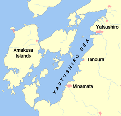
Amakusa is a series of islands belonging to Japan
Japan
Japan is an island nation in East Asia. Located in the Pacific Ocean, it lies to the east of the Sea of Japan, China, North Korea, South Korea and Russia, stretching from the Sea of Okhotsk in the north to the East China Sea and Taiwan in the south...
, off the west coast of Kyushu
Kyushu
is the third largest island of Japan and most southwesterly of its four main islands. Its alternate ancient names include , , and . The historical regional name is referred to Kyushu and its surrounding islands....
(southern tip of Japan). The biggest of the Amakusa islands is Shimoshima Island, 26.5 miles long and 13.5 miles in extreme width (26.5 by 13.5 mi (42.6 by 21.7 km)). It is situated about 32°20'N, 130°E, on the west of Kumamoto Prefecture
Kumamoto Prefecture
is a prefecture of Japan located on Kyushu Island. The capital is the city of Kumamoto.- History :Historically the area was called Higo Province; and the province was renamed Kumamoto during the Meiji Restoration. The creation of prefectures was part of the abolition of the feudal system...
(formerly the province of Higo
Higo Province
Higo Province was an old province of Japan in the area that is today Kumamoto Prefecture on the island of Kyūshū. It was sometimes called , with Hizen Province. Higo bordered on Chikugo, Bungo, Hyūga, Ōsumi, and Satsuma Provinces....
on the island of Kyūshū), from which it is separated by the Yatsushiro Sea
Yatsushiro Sea
The ', which is also called the ', is a shallow semi-enclosed inland sea separating the island of Kyūshū from the Amakusa Islands. It lies mostly within Kumamoto Prefecture and at the southern end of the sea it also borders Kagoshima Prefecture. To the north is the Ariake Sea; to the south, the...
.
It has no high mountain
Mountain
Image:Himalaya_annotated.jpg|thumb|right|The Himalayan mountain range with Mount Everestrect 58 14 160 49 Chomo Lonzorect 200 28 335 52 Makalurect 378 24 566 45 Mount Everestrect 188 581 920 656 Tibetan Plateaurect 250 406 340 427 Rong River...
s, but its surface is very hill
Hill
A hill is a landform that extends above the surrounding terrain. Hills often have a distinct summit, although in areas with scarp/dip topography a hill may refer to a particular section of flat terrain without a massive summit A hill is a landform that extends above the surrounding terrain. Hills...
y—four of the peaks rise to a height of over 1500 feet (457.2 m). So, the population resorts to the terrace
Terrace (agriculture)
Terraces are used in farming to cultivate sloped land. Graduated terrace steps are commonly used to farm on hilly or mountainous terrain. Terraced fields decrease erosion and surface runoff, and are effective for growing crops requiring much water, such as rice...
system of cultivation
Tillage
Tillage is the agricultural preparation of the soil by mechanical agitation of various types, such as digging, stirring, and overturning. Examples of human-powered tilling methods using hand tools include shovelling, picking, mattock work, hoeing, and raking...
, with remarkable success.
A number of the heads of the Christians
Christianity
Christianity is a monotheistic religion based on the life and teachings of Jesus as presented in canonical gospels and other New Testament writings...
executed
Capital punishment
Capital punishment, the death penalty, or execution is the sentence of death upon a person by the state as a punishment for an offence. Crimes that can result in a death penalty are known as capital crimes or capital offences. The term capital originates from the Latin capitalis, literally...
in connection with the Shimabara rebellion
Shimabara Rebellion
The was an uprising largely involving Japanese peasants, most of them Catholic Christians, in 1637–1638 during the Edo period.It was one of only a handful of instances of serious unrest during the relatively peaceful period of the Tokugawa shogunate's rule...
, in 1637-1638, were buried on this island. Amakusa produces a little coal
Coal
Coal is a combustible black or brownish-black sedimentary rock usually occurring in rock strata in layers or veins called coal beds or coal seams. The harder forms, such as anthracite coal, can be regarded as metamorphic rock because of later exposure to elevated temperature and pressure...
and fine kaolin, which was largely used in former times by the potters
Pottery
Pottery is the material from which the potteryware is made, of which major types include earthenware, stoneware and porcelain. The place where such wares are made is also called a pottery . Pottery also refers to the art or craft of the potter or the manufacture of pottery...
of Hirado and Satsuma Province
Satsuma Province
was an old province of Japan that is now the western half of Kagoshima Prefecture on the island of Kyūshū. Its abbreviation is Sasshū .During the Sengoku Period, Satsuma was a fief of the Shimazu daimyo, who ruled much of southern Kyūshū from their castle at Kagoshima city.In 1871, with the...
. Hidenoshin Koyama, who built Thomas Blake Glover
Thomas Blake Glover
Thomas Blake Glover, Order of the Rising Sun was a Scottish merchant in Bakumatsu and Meiji period Japan.-Early life :...
's House in Glover Garden
Glover Garden
thumb|right|250px|Glover House known as Ipponmatsu from a drawing of 1863. The tree was chopped down in the early 1900s is a park in Nagasaki, Japan built for Thomas Blake Glover, a Scottish entrepreneur who contributed to the modernization of Japan in shipbuilding, coal mining, and many other...
, came from this island.
In modern times, Amakusa District, Kumamoto
Amakusa District, Kumamoto
is a district located in Kumamoto Prefecture, Japan.Following the March 27, 2006 Amakusa merger the district consists of the single town of Reihoku. After the merger, the district has an estimated population of 9,105 and a density of 135.77 persons per km²...
is a district, and Amakusa, Kumamoto
Amakusa, Kumamoto
was a town located in Amakusa District, Kumamoto, Japan.Amakusa-machi consists of five villages, four spread along the west coast of Shimo-shima and one located in the mountains between the coast and Hondo, the administrative capital of Amakusa city. They are, in order of geographic location...
is a city
Cities of Japan
||A is a local administrative unit in Japan. Cities are ranked on the same level as and , with the difference that they are not a component of...
in Kumamoto Prefecture
Kumamoto Prefecture
is a prefecture of Japan located on Kyushu Island. The capital is the city of Kumamoto.- History :Historically the area was called Higo Province; and the province was renamed Kumamoto during the Meiji Restoration. The creation of prefectures was part of the abolition of the feudal system...
.
Transport
The islands are served by Amakusa AirfieldAmakusa Airfield
is an airport located northwest of Amakusa, Kumamoto, Japan, on the Amakusa Islands . Locals often referred to the airfield as Amakusa Airport. It is located on the northern side of the Amakusa Islands, north east of Amakusa city...
, located on the north end of Shimoshima Island (the largest island). There are also road bridges and ferry boats between some islands. The islands are connected to the mainland by the Five Bridges of Amakusa
Five Bridges of Amakusa
are five road bridges at the south tip of Japan, linking the Kyushu mainland and the Amakusa Islands. The bridges connect to the islands of Ooyano-jima, Nagaura-jima, Ike-jima, and Maeshima, and were completed on September 24, 1966...
.
Ferry boats travel, several times per day, between islands. The ferry from Reihoku on the north of the Amakusa peninsula to Kuchinotsu, at the southern tip of the Shimabara Peninsula, is run by the Shimbara Railway Co. Services and operates frequently each day. The ferry boat from Tomioka Port in northern Amakusa, sailing north to Mogi/Motegi in Nagasaki Prefecture, is operated by Yasuda Sangyo Kisen Co. Ltd.