
Altitudinal zonation
Encyclopedia
Altitudinal zonation in mountainous regions describes the natural layering of ecosystems that occurs at distinct altitudes due to varying environmental conditions. Temperature, humidity
, soil composition, and solar radiation are important factors in determining altitudinal zones, which consequently support different vegetation and animal species. Altitudinal zonation was first hypothesized by geographer Alexander von Humboldt
who noticed that temperature drops with increasing elevation. Altitudinal zones are not distinct in nature but form intermediate zones between layers that exhibit characteristics of both the upper and lower levels. Altitudinal zonation also occurs in intertidal
and marine environments. In addition, scientist C. Hart Merriam
observed that changes in vegetation and animals in altitudinal zones map onto changes expected with increased latitude in his concept of life zones.
to indirect characteristics of the mountain itself.
Decreasing air temperature usually coincides with increasing elevation, and this decreasing temperature most directly influences the length of frost or ice days at different altitudes of the mountain. Decreasing air temperature usually coincides with increasing elevation, and this decreasing temperature most directly influences the length of frost or ice days at different altitudes of the mountain. On the other hand, for mountains located in deserts, the extreme high temperatures also limit the ability of large deciduous
or coniferous trees to grow, while shrubs and grasses thrive near the base of mountains. In addition, plants are especially sensitive to soil temperatures and have very specific ranges that support healthy growth.
The humidity
of certain zones, including precipitation levels, atmospheric humidity
, and potential for evapotranspiration
, varies with altitude and is a significant factor in determining altitudinal zonation. The most important variable is precipitation at various altitudes. As warm, moist air rises up the windward side of a mountain, the air temperature cools and loses its capacity to hold moisture. Thus, the greatest amount of rainfall is expected at mid-altitudes and can support deciduous forest development. Above a certain elevation the rising air becomes too dry and cold, and thus the density of trees becomes more sparse and eventually are reduced to scrub or dwarfs shrubs. Although rainfall may not be a significant factors for some mountains, atmospheric humidity
or aridity can be more important climatic stresses that affect altitudinal zones. Both overall levels of precipitation and humidity
influence soil moisture as well. One of the most important factors that controls the lower boundary of the encinal or forest level is the ratio of evaporation
to soil moisture.
The nutrient content of soils at different altitudes further complicates the demarcation of altitudinal zones. Soils with higher nutrient content due to higher decomposition rates or greater weathering of rocks would better support larger trees and vegetation. However, predicting what altitudes yield these conditions is difficult to determine and varies with each mountain studied. For example, for mountains found in the tropical rain forest regions, lower elevations exhibit fewer terrestrial species because of the thick layer of dead fallen leaves covering the forest floor. At this latitude more acidic, humose soils exist at higher elevations in the montane or subapline levels. On the other hand, weathering is hampered by low temperatures at higher elevations in the Rocky Mountain of the western United States, resulting in thin coarse soils.
Light is another significant factor in the growth of trees and other photosynthetic
vegetation. The earth’s atmosphere is filled with water vapor, particulate matter, and gases that filter the radiation coming from the sun before reaching the earth’s surface. Hence, the summits of mountains and higher elevations receive much more intense radiation than the basal plains. Along with the expected arid
conditions at higher elevations, shrubs and grasses tend to thrive because of their small leaves and extensive root systems. However, high elevations also tend to have more frequent cloud cover, which compensates for some of the high intensity radiation.
The physical characteristics and relative location of the mountain itself must also be considered in predicting altitudinal zonation patterns. The Massenerhebung effect
describes variation in the tree line based on mountain size and location. This effect predicts that zonation of rain forests on lower mountains may mirror the zonation expected on high mountains, even though the absolute altitudes of the belts are lower. A similar effect is exhibited in the Santa Catalina mountains in Arizona where the basal elevation and the total elevation influence the absolute altitude of vertical zones of vegetation.
In addition to the factors described above, there are a host of other properties that can confound predictions of altitudinal zonations. These include: frequency of disturbance (such as fire or monsoons), wind velocity, topography, competition and other biological influences, nearness to streams or rivers, history of tectonic activity, and latitude.
 Elevation models of zonation are complicated by factors discussed above and thus the relative altitudes each zone begins and ends is not tied to a specific altitude. However it is possible to split the altitudinal gradient into five main zones used by ecologists under varying names.
For detailed breakdowns of the characteristics of altitudinal zones found on different mountains, see Climate zones by altitude
.
.
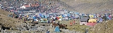
Human populations have developed agricultural production strategies to exploit varying characteristics of altitudinal zones. Altitude, climate, and soil fertility set upper limits on types of crops that can reside in each zone. Populations residing in the Andes
Mountain region of South America have taken advantage of varying altitudinal environments to raise a wide variety of different crops. Two different types of adaptive strategies have been adopted within mountainous communities.
With improved accessibility to new farming techniques, populations are adopting more specialized strategies and moving away from generalized strategies. Many farming communities now choose to trade with communities at different altitudes instead of cultivating every resource on their own because it is cheaper and easier to specialize within their altitudinal zone.
Population growth is causing environmental degradation
in altitudinal environments through deforestation
and overgrazing
. The increase in accessibility of mountainous regions allows more people to travel between areas and encourage groups to expand commercial land use. Furthermore, the new linkage between mountainous and lowland populations from improved road access has contributed to worsening environmental degradation
.
Humidity
Humidity is a term for the amount of water vapor in the air, and can refer to any one of several measurements of humidity. Formally, humid air is not "moist air" but a mixture of water vapor and other constituents of air, and humidity is defined in terms of the water content of this mixture,...
, soil composition, and solar radiation are important factors in determining altitudinal zones, which consequently support different vegetation and animal species. Altitudinal zonation was first hypothesized by geographer Alexander von Humboldt
Alexander von Humboldt
Friedrich Wilhelm Heinrich Alexander Freiherr von Humboldt was a German naturalist and explorer, and the younger brother of the Prussian minister, philosopher and linguist Wilhelm von Humboldt...
who noticed that temperature drops with increasing elevation. Altitudinal zones are not distinct in nature but form intermediate zones between layers that exhibit characteristics of both the upper and lower levels. Altitudinal zonation also occurs in intertidal
Intertidal zone
The intertidal zone is the area that is above water at low tide and under water at high tide . This area can include many different types of habitats, with many types of animals like starfish, sea urchins, and some species of coral...
and marine environments. In addition, scientist C. Hart Merriam
Clinton Hart Merriam
Clinton Hart Merriam was an American zoologist, ornithologist, entomologist and ethnographer.Known as "Hart" to his friends, Dr. Clinton Hart Merriam was born in New York City in 1855. His father, Clinton Levi Merriam, was a U.S. congressman. He studied biology and anatomy at Yale University and...
observed that changes in vegetation and animals in altitudinal zones map onto changes expected with increased latitude in his concept of life zones.
Factors Determining Levels of Altitudinal Zonation
A variety of environmental factors determines the boundaries of altitudinal zones found on mountains, ranging from direct effects of temperature and precipitationPrecipitation (meteorology)
In meteorology, precipitation In meteorology, precipitation In meteorology, precipitation (also known as one of the classes of hydrometeors, which are atmospheric water phenomena is any product of the condensation of atmospheric water vapor that falls under gravity. The main forms of precipitation...
to indirect characteristics of the mountain itself.
- Temperature
Decreasing air temperature usually coincides with increasing elevation, and this decreasing temperature most directly influences the length of frost or ice days at different altitudes of the mountain. Decreasing air temperature usually coincides with increasing elevation, and this decreasing temperature most directly influences the length of frost or ice days at different altitudes of the mountain. On the other hand, for mountains located in deserts, the extreme high temperatures also limit the ability of large deciduous
Deciduous
Deciduous means "falling off at maturity" or "tending to fall off", and is typically used in reference to trees or shrubs that lose their leaves seasonally, and to the shedding of other plant structures such as petals after flowering or fruit when ripe...
or coniferous trees to grow, while shrubs and grasses thrive near the base of mountains. In addition, plants are especially sensitive to soil temperatures and have very specific ranges that support healthy growth.
- Humidity
The humidity
Humidity
Humidity is a term for the amount of water vapor in the air, and can refer to any one of several measurements of humidity. Formally, humid air is not "moist air" but a mixture of water vapor and other constituents of air, and humidity is defined in terms of the water content of this mixture,...
of certain zones, including precipitation levels, atmospheric humidity
Humidity
Humidity is a term for the amount of water vapor in the air, and can refer to any one of several measurements of humidity. Formally, humid air is not "moist air" but a mixture of water vapor and other constituents of air, and humidity is defined in terms of the water content of this mixture,...
, and potential for evapotranspiration
Evapotranspiration
Evapotranspiration is a term used to describe the sum of evaporation and plant transpiration from the Earth's land surface to atmosphere. Evaporation accounts for the movement of water to the air from sources such as the soil, canopy interception, and waterbodies...
, varies with altitude and is a significant factor in determining altitudinal zonation. The most important variable is precipitation at various altitudes. As warm, moist air rises up the windward side of a mountain, the air temperature cools and loses its capacity to hold moisture. Thus, the greatest amount of rainfall is expected at mid-altitudes and can support deciduous forest development. Above a certain elevation the rising air becomes too dry and cold, and thus the density of trees becomes more sparse and eventually are reduced to scrub or dwarfs shrubs. Although rainfall may not be a significant factors for some mountains, atmospheric humidity
Humidity
Humidity is a term for the amount of water vapor in the air, and can refer to any one of several measurements of humidity. Formally, humid air is not "moist air" but a mixture of water vapor and other constituents of air, and humidity is defined in terms of the water content of this mixture,...
or aridity can be more important climatic stresses that affect altitudinal zones. Both overall levels of precipitation and humidity
Humidity
Humidity is a term for the amount of water vapor in the air, and can refer to any one of several measurements of humidity. Formally, humid air is not "moist air" but a mixture of water vapor and other constituents of air, and humidity is defined in terms of the water content of this mixture,...
influence soil moisture as well. One of the most important factors that controls the lower boundary of the encinal or forest level is the ratio of evaporation
Evaporation
Evaporation is a type of vaporization of a liquid that occurs only on the surface of a liquid. The other type of vaporization is boiling, which, instead, occurs on the entire mass of the liquid....
to soil moisture.
- Soil Composition
The nutrient content of soils at different altitudes further complicates the demarcation of altitudinal zones. Soils with higher nutrient content due to higher decomposition rates or greater weathering of rocks would better support larger trees and vegetation. However, predicting what altitudes yield these conditions is difficult to determine and varies with each mountain studied. For example, for mountains found in the tropical rain forest regions, lower elevations exhibit fewer terrestrial species because of the thick layer of dead fallen leaves covering the forest floor. At this latitude more acidic, humose soils exist at higher elevations in the montane or subapline levels. On the other hand, weathering is hampered by low temperatures at higher elevations in the Rocky Mountain of the western United States, resulting in thin coarse soils.
- Solar Radiation
Light is another significant factor in the growth of trees and other photosynthetic
Photosynthesis
Photosynthesis is a chemical process that converts carbon dioxide into organic compounds, especially sugars, using the energy from sunlight. Photosynthesis occurs in plants, algae, and many species of bacteria, but not in archaea. Photosynthetic organisms are called photoautotrophs, since they can...
vegetation. The earth’s atmosphere is filled with water vapor, particulate matter, and gases that filter the radiation coming from the sun before reaching the earth’s surface. Hence, the summits of mountains and higher elevations receive much more intense radiation than the basal plains. Along with the expected arid
Arid
A region is said to be arid when it is characterized by a severe lack of available water, to the extent of hindering or even preventing the growth and development of plant and animal life...
conditions at higher elevations, shrubs and grasses tend to thrive because of their small leaves and extensive root systems. However, high elevations also tend to have more frequent cloud cover, which compensates for some of the high intensity radiation.
- Massenerhebung Effect
The physical characteristics and relative location of the mountain itself must also be considered in predicting altitudinal zonation patterns. The Massenerhebung effect
Massenerhebung effect
The Massenerhebung effect describes variation in the tree line based on mountain size and location. In general, mountains surrounded by large ranges will tend to have higher tree lines than more isolated mountains due to heat retention and wind shadowing...
describes variation in the tree line based on mountain size and location. This effect predicts that zonation of rain forests on lower mountains may mirror the zonation expected on high mountains, even though the absolute altitudes of the belts are lower. A similar effect is exhibited in the Santa Catalina mountains in Arizona where the basal elevation and the total elevation influence the absolute altitude of vertical zones of vegetation.
- Other Factors to Consider
In addition to the factors described above, there are a host of other properties that can confound predictions of altitudinal zonations. These include: frequency of disturbance (such as fire or monsoons), wind velocity, topography, competition and other biological influences, nearness to streams or rivers, history of tectonic activity, and latitude.
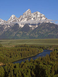
Levels
- Nival Level (Glacier): Covered in snow throughout most of the year. Vegetation is extremely limited to only a few species that thrive on silica soils.
- Sub-Nival Level (in the tropics this zone is referred to as the Tierra Nevada): The highest zone that vegetation typically exists. Vegetation is patchy and is restricted to only the most favorable locations that are protected from the heavy winds that often characterize this area. Very hardy, low-lying species of lichenLichenLichens are composite organisms consisting of a symbiotic organism composed of a fungus with a photosynthetic partner , usually either a green alga or cyanobacterium...
, mossMossMosses are small, soft plants that are typically 1–10 cm tall, though some species are much larger. They commonly grow close together in clumps or mats in damp or shady locations. They do not have flowers or seeds, and their simple leaves cover the thin wiry stems...
and grass tufts typical of arctic zones populate this region. Snow is found in this region for part of the year. - Alpine Level: The zone that stretches between the tree line and snowline. This zone is further broken down into Sub-Nival and Treeless Alpine (in the tropics-Tierra fria; low-alpine)
- Sub Nival (tropics-Tierra helada): This area is shaped by the frequent frosts that restrict extensive plant colonization. Much of this region is patchy grassland, sedges and rush heaths. This region is sometimes used as high altitude grazing land and is often considered particularly able to withstand land use.
- Treeless Alpine (tropics-Tierra fria; low-alpine): Characterized by a closed carpet of vegetation that includes alpine meadows, shrubs and sporadic dwarfed trees. Because of the complete cover of vegetation, frost has less of an effect on this region, but due to the consistent freezing temperatures tree growth is severely limited.
- Montane Level (tropics-Tierra templada): Extends from the mid-altitude forests to the tree line. The exact level of the tree line varies with local climate, but typically the tree line is found where mean monthly soil temperatures never exceed 10.0 degrees C and the mean annual soil temperatures are around 6.7 degrees C. In the tropics, this region is typified by montane rain forest (above 3,000 ft) while at higher latitudes coniferous forests often dominate.
- Lowland Layer (tropics-Tierra caliente): This lowest section of mountains varies distinctly across climates and is referred to by a wide range of names depending on the surrounding landscape. Colline zones are found in tropical regions and Encinal zones and desert grasslands are found in desert regions.
- Colline (Tropics): Characterized by deciduous forests when in oceanic or moderately continental areas, and characterized by grassland in more continental regions. Extends from sea level to about 3,000 feet (roughly 900 m). Vegetation is abundant and dense. This zone is the typical base layer of tropical regions.
- Encinal (deserts): Characterized by open evergreenEvergreenIn botany, an evergreen plant is a plant that has leaves in all seasons. This contrasts with deciduous plants, which completely lose their foliage during the winter or dry season.There are many different kinds of evergreen plants, both trees and shrubs...
oak forests and most common in desert regions. EvaporationEvaporationEvaporation is a type of vaporization of a liquid that occurs only on the surface of a liquid. The other type of vaporization is boiling, which, instead, occurs on the entire mass of the liquid....
and soil moisture control limitation of which encinal environments can thrive. Desert grasslands lie below encinal zones. Very commonly found in the Southwestern United States. - Desert grassland: Characterized by varying densities of low lying vegetation, grasslands zones cannot support trees due to extreme aridity. Some desert regions may support trees at base of mountains however, and thus distinct grasslands zones will not form in these areas.
For detailed breakdowns of the characteristics of altitudinal zones found on different mountains, see Climate zones by altitude
Climate zones by altitude
The climate and ecology of land immediately surrounding the Mediterranean Sea is influenced by several factors. Overall, the land has a Mediterranean climate, with mild, rainy winters and hot, dry summers. The climate induces characteristic Mediterranean forests, woodlands, and scrub vegetation...
.
Animal Zonation
Animals also exhibit zonation patterns in concert with the vegetational zones described above. Invertebrates are more clearly defined into zones because they are typically less mobile than vertebrate species. Vertebrate animals often span across altitudinal zones according to the seasons and food availability. Typically animal species diversity and abundance decrease as a function of altitude above the montane zone because of the harsher environmental conditions experienced at higher altitudes. Fewer studies have explored animal zonation with altitude because this correlation is less defined than the vegetation zones due to the increased mobility of animal species.Land-Use Planning and Human Utilization
The variability of both natural and human environments has made it difficult to construct universal models to explain human cultivation in altitudinal environments. With more established roads however, the bridge between different cultures has started to shrink. Mountainous environments have become more accessible and diffusion of ideas, technology, and goods occur with more regularity. Nonetheless, altitudinal zonation caters to agricultural specialization and growing populations cause environmental degradationEnvironmental degradation
Environmental degradation is the deterioration of the environment through depletion of resources such as air, water and soil; the destruction of ecosystems and the extinction of wildlife...
.
- Agriculture
Human populations have developed agricultural production strategies to exploit varying characteristics of altitudinal zones. Altitude, climate, and soil fertility set upper limits on types of crops that can reside in each zone. Populations residing in the Andes
Andes
The Andes is the world's longest continental mountain range. It is a continual range of highlands along the western coast of South America. This range is about long, about to wide , and of an average height of about .Along its length, the Andes is split into several ranges, which are separated...
Mountain region of South America have taken advantage of varying altitudinal environments to raise a wide variety of different crops. Two different types of adaptive strategies have been adopted within mountainous communities.
- Generalized Strategy – exploits a series of microniches or ecozoneEcozoneAn ecozone is the broadest biogeographic division of the Earth's land surface, based on distributional patterns of terrestrial organisms.Ecozones delineate large areas of the Earth's surface within which organisms have been evolving in relative isolation over long periods of time, separated from...
s at several altitudinal levels - Specialized Strategy – focuses on a single zone and specializes in the agricultural activities suitable to that altitude, developing elaborate trade relationships with external populations
With improved accessibility to new farming techniques, populations are adopting more specialized strategies and moving away from generalized strategies. Many farming communities now choose to trade with communities at different altitudes instead of cultivating every resource on their own because it is cheaper and easier to specialize within their altitudinal zone.
- Environmental Degradation from Humans
Population growth is causing environmental degradation
Environmental degradation
Environmental degradation is the deterioration of the environment through depletion of resources such as air, water and soil; the destruction of ecosystems and the extinction of wildlife...
in altitudinal environments through deforestation
Deforestation
Deforestation is the removal of a forest or stand of trees where the land is thereafter converted to a nonforest use. Examples of deforestation include conversion of forestland to farms, ranches, or urban use....
and overgrazing
Overgrazing
Overgrazing occurs when plants are exposed to intensive grazing for extended periods of time, or without sufficient recovery periods. It can be caused by either livestock in poorly managed agricultural applications, or by overpopulations of native or non-native wild animals.Overgrazing reduces the...
. The increase in accessibility of mountainous regions allows more people to travel between areas and encourage groups to expand commercial land use. Furthermore, the new linkage between mountainous and lowland populations from improved road access has contributed to worsening environmental degradation
Environmental degradation
Environmental degradation is the deterioration of the environment through depletion of resources such as air, water and soil; the destruction of ecosystems and the extinction of wildlife...
.
Debate on Continuum vs. Zonation
Not all mountainous environments exhibit sudden changes in altitudinal zones. Though less common, some tropical environments show a slow continuous change in vegetation over the altitudinal gradient and thus do not form distinct vegetation zones.Examples
- Life zones of central EuropeLife zones of central EuropeCentral Europe contains several life zones, depending on location and elevation.Geographically, Central Europe lies between the Baltic Sea and the Apennine and Balkan peninsulas. It includes the plains of Germany and Poland; the Alps; and the Carpathian Mountains. The Central European Flora region...
- Life zones of the Mediterranean region
- Life zones of the North Cascades in the Pacific Northwest of AmericaEcology of the North CascadesThe Ecology of the North Cascades is heavily influenced by the high elevation and rain shadow effects of the mountain range. The North Cascades is a section of the Cascade Range from the South Fork of the Snoqualmie River in Washington, United States, to the confluence of the Thompson and Fraser...
- Life zones of the Sierra Nevada in California
- Life zones of Peru