

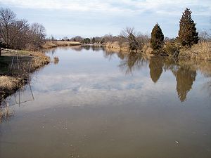
Alloway Creek
Encyclopedia
Tributary
A tributary or affluent is a stream or river that flows into a main stem river or a lake. A tributary does not flow directly into a sea or ocean...
of the Delaware River
Delaware River
The Delaware River is a major river on the Atlantic coast of the United States.A Dutch expedition led by Henry Hudson in 1609 first mapped the river. The river was christened the South River in the New Netherland colony that followed, in contrast to the North River, as the Hudson River was then...
in Salem County
Salem County, New Jersey
-Demographics:As of the census of 2000, there were 64,285 people, 24,295 households, and 17,370 families residing in the county. The population density was 190 people per square mile . There were 26,158 housing units at an average density of 77 per square mile...
, southwestern New Jersey
New Jersey
New Jersey is a state in the Northeastern and Middle Atlantic regions of the United States. , its population was 8,791,894. It is bordered on the north and east by the state of New York, on the southeast and south by the Atlantic Ocean, on the west by Pennsylvania and on the southwest by Delaware...
in the U.S.
United States
The United States of America is a federal constitutional republic comprising fifty states and a federal district...
The headwaters of the creek are to the southeast of Daretown, in Upper Pittsgrove Township
Upper Pittsgrove Township, New Jersey
Upper Pittsgrove Township is a Township in Salem County, New Jersey, United States. As of the 2000 United States Census, the township population was 3,468.Upper Pittsgrove Township was incorporated on March 10, 1846, from portions of Pittsgrove Township...
. It flows roughly parallel and to the south of Commissioners Pike, meeting Cool Run before turning west and flowing under the pike. Entering a marshy area, it meets an unnamed tributary and flows under Alloway Road. Here the creek enters Alloway Lake, formed by a dam at the town of Alloway and the largest lake in Salem County. Cedar Brook also feeds the lake, entering from the south.
Below the dam at Alloway, the creek becomes a tidal marsh and meadow estuary. About a mile west of the dam, Deep Run enters from the south. The meander
Meander
A meander in general is a bend in a sinuous watercourse. A meander is formed when the moving water in a stream erodes the outer banks and widens its valley. A stream of any volume may assume a meandering course, alternately eroding sediments from the outside of a bend and depositing them on the...
s of the creek become pronounced as the creek turns to flow southwest towards Quinton, where it receives the outlet of Laurel Lake, the water supply for Salem
Salem, New Jersey
Salem is a city in Salem County, New Jersey, United States. As of the United States 2010 Census, the city population was 5,146. It is the county seat of Salem County, the most rural county in the state of New Jersey. The name Salem is related to the Hebrew word shalom, meaning "peace".The town and...
. Route 49
Route 49 (New Jersey)
Route 49 is a state highway in the southern part of the U.S. state of New Jersey. It runs from an interchange with the Delaware Memorial Bridge extension of the New Jersey Turnpike in Deepwater, Salem County, where it continues north as U.S. Route 130 southeast to Route 50 and County Route 557 in...
crosses the creek at Quinton. Below Hancock's Bridge
Hancock's Bridge, New Jersey
Hancock's Bridge is an unincorporated area located within Lower Alloways Creek Township in Salem County, New Jersey, United States. The area is served as United States Postal Service ZIP code 08038....
, the creek enters the marshes fringing the Delaware. A network of estuarine channels known as Abbotts Meadow lies on the north side. On the south side, a channel has been cut across a meander; Alloway Hope Halfway, a tidal channel connecting with Hope Creek, enters the south side of the meander loop there. The island in the middle of the loop and the land on the south bank from the meander to the mouth are part of Mad Horse Creek Wildlife Management Area.
The Alloway Creek watershed is 75 square miles (194.2 km²), accounting for about 20% of Salem County land area, and providing a habitat essential for commercial and sport fishing, hunting and trapping.
A volunteer organization called Delaware Riverkeeper has a monitoring site at the Route 49 bridge in Quinton. As of 1995, Riverkeepers regularly tested the surface water and recorded stream conditions. The goal of Riverkeeper is to ensure that the Delaware River and every tributary stream of the watershed is actively protected by local residents.
External links
- Mouth of the creek