

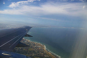
Algoa Bay
Encyclopedia
Cape of Good Hope
The Cape of Good Hope is a rocky headland on the Atlantic coast of the Cape Peninsula, South Africa.There is a misconception that the Cape of Good Hope is the southern tip of Africa, because it was once believed to be the dividing point between the Atlantic and Indian Oceans. In fact, the...
. It is bounded in the west by Cape Recife and in the east by Cape Padrone. The bay is up to 436 m deep. The harbour city of Port Elizabeth is situated adjacent to the bay, as is the new Coega
Coega
The Coega Industrial Development Zone covering 110 km² of land , is situated in the Nelson Mandela Municipality, Eastern Cape province of South Africa in the Nelson Mandela Metropolitan Municipality near Port Elizabeth...
deep water port facility.
Port Elizabeth
The metropolitan municipality of Nelson Mandela BayNelson Mandela Municipality
Nelson Mandela Bay Municipality is one of six Metropolitan municipalities in South Africa. It is located on the shores of Algoa Bay in the Eastern Cape province, and comprises the city of Port Elizabeth, the nearby towns of Uitenhage and Despatch, and the surrounding rural area.The name "Nelson...
, which includes Port Elizabeth, is located on the western shore of Algoa Bay.
Portuguese discovery
The Portuguese explorer Bartolomeu DiasBartolomeu Dias
Bartolomeu Dias , a nobleman of the Portuguese royal household, was a Portuguese explorer who sailed around the southernmost tip of Africa in 1488, the first European known to have done so.-Purposes of the Dias expedition:...
was the first European to reach Algoa Bay in 1488, where he planted a wooden cross on a small island now called St Croix or Santa Cruz island. He gave the bay a name meaning "Bay of the Rock", which was changed in Portugal to Bahia de Lagoa or Bay of the Lagoon, and which eventually became Algoa Bay.
Joshua Slocum
Joshua Slocum
Joshua Slocum was the first man to sail single-handedly around the world. He was a Canadian born, naturalised American seaman and adventurer, and a noted writer. In 1900 he told the story of this in Sailing Alone Around the World...
talks about Algoa Bay in his book 'Sailing Alone Around the World
Sailing Alone Around the World
Sailing Alone Around the World is a sailing memoir by Joshua Slocum about his single-handed global circumnavigation aboard the sloop Spray. Slocum was the first person to sail around the world alone...
':
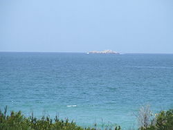
Islands
The bay contains six named islands in two groups of three that according to BirdLife InternationalBirdLife International
BirdLife International is a global Partnership of conservation organisations that strives to conserve birds, their habitats and global biodiversity, working with people towards sustainability in the use of natural resources...
“are of considerable importance as they are the only islands along a 1,777 km stretch of coastline between Cape Agulhas
Cape Agulhas
Cape Agulhas is a rocky headland in the Western Cape, South Africa. It is the geographic southern tip of Africa and the official dividing point between the Atlantic and Indian oceans...
and Inhaca Island in Mozambique." The combined surface area of these islands is said to be 40 hectares.
Close inshore, near the new Ngquru harbour development at Coega
Coega
The Coega Industrial Development Zone covering 110 km² of land , is situated in the Nelson Mandela Municipality, Eastern Cape province of South Africa in the Nelson Mandela Metropolitan Municipality near Port Elizabeth...
, on the north-eastern outskirts of Port Elizabeth, is the St Croix group, consisting of a main island of that name and two lesser islets, Jahleel Island just off the Ngquru breakwater and Brenton Island on the seaward side. The second group consists of Bird, Seal and Stag Islands. All six islands and their adjacent waters are declared nature reserves and form part of the Addo Elephant National Park
Addo Elephant National Park
Addo Elephant National Park is an elephant park situated close to Port Elizabeth in South Africa and is recognized as one of the country's twenty national parks.- History :...
. The islands are closed to the public.
Also worthy of mention, if only as an obstacle to navigation, is Despatch Rock, 2.4 km due east of the Port Elizabeth suburb of Summerstrand. The rock, which is submerged at high tide, is marked with a light. Further south, about a kilometre southwest of Cape Recife, the western starting point of the bay is Thunderbolt Reef. Though not in the bay, this hazard to navigation has claimed many ships carelessly entering or leaving. Thunderbolt Reef is submerged save for spring low tides and the surf crashing on it can be observed from the mainland.
The St Croix group

Brenton Island (33°49′3"S 25°45′54"E) is equally sparsely vegetated and is less than 20 metres in elevation, and is roughly 250 m by 200 m in size with a northwest-southeast orientation. It is 5.75 km to sea from the nearest point on the mainland and 1.75 km south of St Croix. Jahleel, at less than 10 metres in height, is just over a kilometre from the closest beach and less than that from Ngquru’s 2.6 km long eastern breakwater. Jahleel is about the same size as Brenton and has a north-south axis. It is 5.75 km west of St Croix.
The Bird Island group
Vasco da Gama
Vasco da Gama, 1st Count of Vidigueira was a Portuguese explorer, one of the most successful in the Age of Discovery and the commander of the first ships to sail directly from Europe to India...
named this group of islands Inhéus Châos (low or flat islands). In 1755, the East Indiaman Doddington was wrecked here while underway from Dover
Dover
Dover is a town and major ferry port in the home county of Kent, in South East England. It faces France across the narrowest part of the English Channel, and lies south-east of Canterbury; east of Kent's administrative capital Maidstone; and north-east along the coastline from Dungeness and Hastings...
to India
India
India , officially the Republic of India , is a country in South Asia. It is the seventh-largest country by geographical area, the second-most populous country with over 1.2 billion people, and the most populous democracy in the world...
. Most of the passengers and crew perished, but a few managed to make it to the islands where they were marooned
Marooning
Marooning is the intentional leaving of someone in a remote area, such as an uninhabited island. The word appears in writing in approximately 1709, and is derived from the term maroon, a word for a fugitive slave, which could be a corruption of Spanish cimarrón, meaning a household animal who has...
for seven months until one of their number, a carpenter, was able to make a boat for them. The survivors subsisted primarily on fish, birds and eggs until they were able to reach land. The ship was carrying a significant quantity of gold and silver, some of which was illegally salvaged in more recent times. Bird Island was named by the survivors as they left the island in their boat.
Bird Island (33°50′26"S 26°17′10"E), Seal Island and Stag Island lie in close proximity some 40 km east of the St Croix group or 53 km due east of Port Elizabeth and 7 km from the nearest landfall at Woody Cape – part of the Addo Elephant National Park
Addo Elephant National Park
Addo Elephant National Park is an elephant park situated close to Port Elizabeth in South Africa and is recognized as one of the country's twenty national parks.- History :...
. Bird Island has a lighthouse, erected in 1898 after a series of wrecks in the vicinity of the island. Doddington Rock, West rock and East Reef lie just South-West of the group of islands.
At 19 hectares, Bird Island is the largest of the Algoa Bay islands – according to BirdLife. It is relatively flat and rises to 9 m. Seal Island is 0.6ha in size and lies 360 m north of Bird Island. Stag Island is even smaller at 0.1ha and is 320 m north-west of Bird Island. "Much of the island group is covered by sparse growth of mixed vegetation dominated by the fleshy herb Mesembryanthemum
Mesembryanthemum
Mesembryanthemum is a genus of plants native to southern Africa. Many species which were formerly placed herein have since been moved into other genera such as Carpobrotus Sceletium is sometimes included here....
(fig marigold/icicle plants). Tetragonia
Tetragonia
Tetragonia is a genus of 50-60 species of flowering plants in the family Aizoaceae, native to temperate and subtropical regions mostly of the Southern Hemisphere, in New Zealand, Australia, southern Africa and South America...
(Duneweed) and Chenopodium
Chenopodium
Chenopodium is a genus of about 150 species of perennial or annual herbaceous flowering plants known as the goosefoots, which occur almost anywhere in the world. It is placed in the family Amaranthaceae in the APG II system; older classifications separate it and its relatives as Chenopodiaceae, but...
(Goosefoot) form localised thickets that provide cover for some seabirds," the fact sheet says.
Bird and wildlife
The BirdLife fact sheet adds that 14 species of seabirds, several species of shorebirds and 33 species of terrestrial birds have been recorded on the islands. Eight seabird species were known to breed on the islands in 2007. “These are the only islands off southern mainland Africa where Sterna dougallii (Roseate TernRoseate Tern
The Roseate Tern is a seabird of the tern family Sternidae. This bird has a number of geographical races, differing mainly in bill colour and minor plumage details....
) breeds regularly.”
The islands are also home to 43% of the global population of the African Penguin
African Penguin
The African Penguin , also known as the Black-footed Penguin is a species of penguin, confined to southern African waters. It is known as Brilpikkewyn in Afrikaans, Inguza or Unombombiya in Xhosa, Manchot Du Cap in French and Pingüino Del Cabo in Spanish...
(Spheniscus demersus), the majority of which are on St Croix. St Croix also holds a locally significant breeding population of Cape Cormorant
Cape Cormorant
The Cape Cormorant or Cape Shag, Phalacrocorax capensis, is a bird endemic to the southwestern coasts of Africa.It breeds from Namibia south to southern Cape Province. In the nonbreeding season, it may be found as far north as the mouth of the Congo, and also extends up the east coast of South...
(Phalacrocorax capensis).
Bird Island is one of only six breeding sites in the world for the Cape Gannet
Cape Gannet
The Cape Gannet, Morus capensis, originally Sula capensis, is a large seabird of the gannet family, Sulidae.They are easily identified by their large size, black and white plumage and distinctive yellow crown and hindneck...
(Morus capensis). “Larus dominicanus (the Kelp Gull
Kelp Gull
The Kelp Gull , also known as the Dominican Gull, breeds on coasts and islands through much of the southern hemisphere. The race L. d. vetula occurs around southern Africa, and nominate L. d...
) and Haematopus moquini (the African Oystercatcher) are found throughout the Algoa Bay complex. The island group is also known to hold large numbers of Sterna vittata (Antarctic Tern
Antarctic Tern
The Antarctic Tern is a typical tern. It ranges throughout the southern oceans. It is very similar in appearance to the closely related Arctic Tern, but is stockier, and the wing tips are grey instead of blackish in flight...
), which in winter roost on the island in their thousands (regularly holding between 10% and 20% of the estimated total Afrotropical non-breeding population).” The island is also home to a Cape Fur Seal
Cape Fur Seal
The brown fur seal , also known as the Cape fur seal, South African fur seal and the Australian fur seal is a species of fur seal.-Description:...
s (Arctocephalus pusillus).
Conservation issues
The St Croix group and a 300 m maritime zone around each island became South Africa’s island marine reserve in 1981 and were administered as part of the then-Woody Cape Nature Reserve. Up to then, the islands had fallen under the control of the Guano Islands section of the Division of Sea Fisheries. The Eastern Cape Nature Conservation service, which subsequently became the Directorate of Nature Conservation of the Eastern CapeEastern Cape
The Eastern Cape is a province of South Africa. Its capital is Bhisho, but its two largest cities are Port Elizabeth and East London. It was formed in 1994 out of the "independent" Xhosa homelands of Transkei and Ciskei, together with the eastern portion of the Cape Province...
Province, managed the islands after April 1992 according to BirdLife. The Woody Cape reserve was subsequently incorporated into the Addo National Elephant Park, which then boasted that it was home to Africa’s “big six” – the elephant, lion, leopard, rhinoceros, buffalo and the Great White Shark
Great white shark
The great white shark, scientific name Carcharodon carcharias, also known as the great white, white pointer, white shark, or white death, is a large lamniform shark found in coastal surface waters in all major oceans. It is known for its size, with the largest individuals known to have approached...
that inhabits the bay.
Conservationists are wary of the Ngquru development which in time, in addition to a deep water port will include a heavy-industry complex. Mooted occupants include an aluminium
Aluminium
Aluminium or aluminum is a silvery white member of the boron group of chemical elements. It has the symbol Al, and its atomic number is 13. It is not soluble in water under normal circumstances....
smelter and an oil refinery
Oil refinery
An oil refinery or petroleum refinery is an industrial process plant where crude oil is processed and refined into more useful petroleum products, such as gasoline, diesel fuel, asphalt base, heating oil, kerosene, and liquefied petroleum gas...
. They see the development as posing, according to BirdLife:
The NGO
Non-governmental organization
A non-governmental organization is a legally constituted organization created by natural or legal persons that operates independently from any government. The term originated from the United Nations , and is normally used to refer to organizations that do not form part of the government and are...
notes that the population of the African Penguin in the bay has been increasing steadily during the last century. “There are only a few growing colonies in the world, and it is thought that these birds may be relocating here from colonies that are in decline in the Western Cape or farther afield. Certain factors are known to affect seabirds throughout their ranges. Competition with commercial fisheries, especially purse-seining for surface-shoaling fish such as anchovy
Anchovy
Anchovies are a family of small, common salt-water forage fish. There are 144 species in 17 genera, found in the Atlantic, Indian, and Pacific Oceans. Anchovies are usually classified as an oily fish.-Description:...
(Engraulis capensis) and pilchard (Sardinops sagax), has been implicated as one of the most significant factors causing seabird population declines." The organisation has recommended that marine reserves with a radius of 25 km be created around important breeding islands, and that commercial fishing be banned or restricted in these zones.
The fact sheet continues: “An unpredictable threat, which is difficult to control, is chronic pollution by crude oil or other pollutants which spill into the ocean when tankers break open, wash their tanks, dump cargo or pump bilge
Bilge
The bilge is the lowest compartment on a ship where the two sides meet at the keel. The word was coined in 1513.-Bilge water:The word is sometimes also used to describe the water that collects in this compartment. Water that does not drain off the side of the deck drains down through the ship into...
. The African Penguin
African Penguin
The African Penguin , also known as the Black-footed Penguin is a species of penguin, confined to southern African waters. It is known as Brilpikkewyn in Afrikaans, Inguza or Unombombiya in Xhosa, Manchot Du Cap in French and Pingüino Del Cabo in Spanish...
(Spheniscus demersus) is particularly susceptible to these events, and a single oil disaster has the ability to severely affect populations. It is believed that the breeding sites in Algoa Bay, at the eastern extremity of the species' range, are at highest risk as they are closest to the major oil-shipping routes.”
Hazards
Nautical chartNautical chart
A nautical chart is a graphic representation of a maritime area and adjacent coastal regions. Depending on the scale of the chart, it may show depths of water and heights of land , natural features of the seabed, details of the coastline, navigational hazards, locations of natural and man-made aids...
s of the bay caution mariners that "projectiles and badly corroded mustard gas containers have been found in the area between Cape St Francis and Bird Island out to depths of 400 metres. Trawlers should exercise the greatest caution."
The chemical weapons
Chemical warfare
Chemical warfare involves using the toxic properties of chemical substances as weapons. This type of warfare is distinct from Nuclear warfare and Biological warfare, which together make up NBC, the military acronym for Nuclear, Biological, and Chemical...
were dumped in the bay in the aftermath of World War II
World War II
World War II, or the Second World War , was a global conflict lasting from 1939 to 1945, involving most of the world's nations—including all of the great powers—eventually forming two opposing military alliances: the Allies and the Axis...
. During that conflict, Port Elizabeth was used as a research, manufacturing and storage site for Allied poison gas. An official at the SA Navy's
South African Navy
The South African Navy is the navy of the Republic of South Africa.-Formation:The South African Navy can trace its official origins back to the SA Naval Service, which was established on 1 April 1922....
Hydrographic Office recalls that at least one trawler once snagged a projectile or canister in its nets and that the crew were badly burned. The condition of the canisters and projectiles are not currently known. There is no record of any recent incidents.