

Alexander MacKenzie Heritage Trail
Encyclopedia
Quesnel, British Columbia
-Demographics:Quesnel had a population of 9,326 people in 2006, which was a decrease of 7.1% from the 2001 census count. The median household income in 2005 for Quesnel was $54,044, which is slightly above the British Columbia provincial average of $52,709....
and Bella Coola
Bella Coola, British Columbia
Bella Coola is a community of approximately 600 at the western extremity of the Bella Coola Valley. Bella Coola usually refers to the entire valley, encompassing the settlements of Bella Coola proper , Lower Bella Coola, Hagensborg, Saloompt, Nusatsum, Firvale and Stuie...
, British Columbia
British Columbia
British Columbia is the westernmost of Canada's provinces and is known for its natural beauty, as reflected in its Latin motto, Splendor sine occasu . Its name was chosen by Queen Victoria in 1858...
, Canada
Canada
Canada is a North American country consisting of ten provinces and three territories. Located in the northern part of the continent, it extends from the Atlantic Ocean in the east to the Pacific Ocean in the west, and northward into the Arctic Ocean...
. Of the many grease trail
Grease trail
A grease trail is an overland trade route, part of a network of trails connecting the Pacific coast with the Interior in the Pacific Northwest. Trails were developed for trade between indigenous people, particularly the trade in eulachon oil. The grease from these small fish could be traded for...
s connecting the Coast
British Columbia Coast
The British Columbia Coast or BC Coast is Canada's western continental coastline on the Pacific Ocean. The usage is synonymous with the term West Coast of Canada....
with the Interior
British Columbia Interior
The British Columbia Interior or BC Interior or Interior of British Columbia, usually referred to only as the Interior, is one of the three main regions of the Canadian province of British Columbia, the other two being the Lower Mainland, which comprises the overlapping areas of Greater Vancouver...
, it is the most notable and often is referred to as the Grease Trail.
The trail was originally used by the Nuxálk
Nuxálk Nation
The Nuxalk Nation , also referred to as the Bella Coola or Bellacoola, are an Indigenous First Nation in Canada, living in the area in and around Bella Coola, British Columbia...
and Carrier
Dakelh
The Dakelh or Carrier are the indigenous people of a large portion of the Central Interior of British Columbia, Canada.Most Carrier call themselves Dakelh, meaning "people who go around by boat"...
people for communication, transport and trade, in particular, trade in Eulachon
Eulachon
The eulachon, also oolichan, hooligan, ooligan, or candlefish, is a small anadromous ocean fish, Thaleichthys pacificus, a smelt found along the Pacific coast of North America from northern California to Alaska....
grease from the Pacific coast.
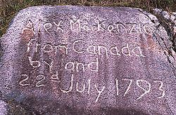
During his trek from Montreal
Montreal
Montreal is a city in Canada. It is the largest city in the province of Quebec, the second-largest city in Canada and the seventh largest in North America...
to the Pacific Ocean
Pacific Ocean
The Pacific Ocean is the largest of the Earth's oceanic divisions. It extends from the Arctic in the north to the Southern Ocean in the south, bounded by Asia and Australia in the west, and the Americas in the east.At 165.2 million square kilometres in area, this largest division of the World...
in the late 18th century, Alexander MacKenzie made use of the overland trail when natural obstacles in the Fraser River
Fraser River
The Fraser River is the longest river within British Columbia, Canada, rising at Fraser Pass near Mount Robson in the Rocky Mountains and flowing for , into the Strait of Georgia at the city of Vancouver. It is the tenth longest river in Canada...
prevented his continued water route. He reached the ocean on July 20, 1793, completing the first recorded transcontinental crossing north of England. The route was designated as an official heritage trail by the Heritage Conservation Act in 1987.
From east to west, the modern-day trail begins at the West Road River
West Road River
The West Road River or Blackwater River is a major tributary of the Fraser River, flowing generally north-eastward from the northern slopes of the Ilgachuz Range and across the Fraser Plateau in the Chilcotin region of central British Columbia, Canada...
(Blackwater River) 53.269063 N,123.148917 W between Quesnel and Prince George, passes Kluskus Lake, Eliguk Lake, then crosses through what is now Tweedsmuir Provincial Park
Tweedsmuir North Provincial Park and Protected Area
Tweedsmuir North Provincial Park and Protected Area is a provincial park in British Columbia, Canada. Formerly part of Tweedsmuir Provincial Park, one of the earliest large parks established in the provincial parks system, it was redesignated a park and protected area as the latter classification...
, then follows the Bella Coola River
Bella Coola River
The Bella Coola River is a major river on the Pacific slope of the Coast Mountains in southern British Columbia. The town of Bella Coola, which is the historic and ancient capital of the Nuxalk people, is at its mouth on North Bentinck Arm...
to the North Bentinck Arm
North Bentinck Arm
North Bentinck Arm is short inlet about in length in the Central Coast region of British Columbia, Canada. It is a sidewater of Burke Channel and is linked via that waterway and Labouchere Channel to Dean Channel, which is one of the largest inlets of the BC Coast.A spot on North Bentinck Arm is...
inlet.
Because of its length and difficulty, experienced hikers can expect the route to take about 18 days, whereas intermediate hikers may require at least 24 days. Also, hikers may choose to hike only sections of the trail, such as the route through Tweedsmuir Provincial Park which passes the extinct
Volcano
2. Bedrock3. Conduit 4. Base5. Sill6. Dike7. Layers of ash emitted by the volcano8. Flank| 9. Layers of lava emitted by the volcano10. Throat11. Parasitic cone12. Lava flow13. Vent14. Crater15...
Rainbow Range
Rainbow Range (Coast Mountains)
The Rainbow Range, formerly known as the Rainbow Mountains, is a mountain range in British Columbia, Canada, located northwest of Anahim Lake...
shield volcano
Shield volcano
A shield volcano is a type of volcano usually built almost entirely of fluid lava flows. They are named for their large size and low profile, resembling a warrior's shield. This is caused by the highly fluid lava they erupt, which travels farther than lava erupted from more explosive volcanoes...
. Only a few hiking or horse riding parties, plus a few ATVs or trucks, pass along the trail each year.
The middle section of the trail passes within 5 km of Pan Phillips' Home Ranch
Tsetzi Lake (Pan Phillips) Airport
Tsetzi Lake Airport, , is located adjacent to Tsetzi Lake, British Columbia, Canada. The name of the lake is pronounced "Tezy,"....
, popularized by the books by Rich Hobson, Grass Beyond the Mountains, Nothing Too Good for a Cowboy, and The Rancher Takes a Wife, and the CBC television series based on the same books. The Home Ranch closed operations in the early 1970s, but the remains of the ranch are in good shape.