

Akeman Street
Encyclopedia
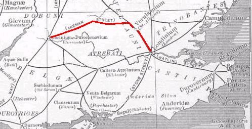
Roman road
The Roman roads were a vital part of the development of the Roman state, from about 500 BC through the expansion during the Roman Republic and the Roman Empire. Roman roads enabled the Romans to move armies and trade goods and to communicate. The Roman road system spanned more than 400,000 km...
in England that linked Watling Street
Watling Street
Watling Street is the name given to an ancient trackway in England and Wales that was first used by the Britons mainly between the modern cities of Canterbury and St Albans. The Romans later paved the route, part of which is identified on the Antonine Itinerary as Iter III: "Item a Londinio ad...
with the Fosse Way
Fosse Way
The Fosse Way was a Roman road in England that linked Exeter in South West England to Lincoln in Lincolnshire, via Ilchester , Bath , Cirencester and Leicester .It joined Akeman Street and Ermin Way at Cirencester, crossed Watling Street at Venonis south...
. Its junction with Watling Steet was just north of Verulamium
Verulamium
Verulamium was an ancient town in Roman Britain. It was sited in the southwest of the modern city of St Albans in Hertfordshire, Great Britain. A large portion of the Roman city remains unexcavated, being now park and agricultural land, though much has been built upon...
(near modern St Albans
St Albans
St Albans is a city in southern Hertfordshire, England, around north of central London, which forms the main urban area of the City and District of St Albans. It is a historic market town, and is now a sought-after dormitory town within the London commuter belt...
) and that with the Fosse Way
Fosse Way
The Fosse Way was a Roman road in England that linked Exeter in South West England to Lincoln in Lincolnshire, via Ilchester , Bath , Cirencester and Leicester .It joined Akeman Street and Ermin Way at Cirencester, crossed Watling Street at Venonis south...
was at Corinium Dobunnorum
Corinium Dobunnorum
Corinium Dobunnorum was the second largest town in the Roman province of Britannia. Today it is known as Cirencester, located in the English county of Gloucestershire.-Fortress:...
(now Cirencester
Cirencester
Cirencester is a market town in east Gloucestershire, England, 93 miles west northwest of London. Cirencester lies on the River Churn, a tributary of the River Thames, and is the largest town in the Cotswold District. It is the home of the Royal Agricultural College, the oldest agricultural...
). Its course passes through towns and villages including Hemel Hempstead
Hemel Hempstead
Hemel Hempstead is a town in Hertfordshire in the East of England, to the north west of London and part of the Greater London Urban Area. The population at the 2001 Census was 81,143 ....
, Berkhamsted
Berkhamsted
-Climate:Berkhamsted experiences an oceanic climate similar to almost all of the United Kingdom.-Castle:...
, Tring
Tring
Tring is a small market town and also a civil parish in the Chiltern Hills in Hertfordshire, England. Situated north-west of London and linked to London by the old Roman road of Akeman Street, by the modern A41, by the Grand Union Canal and by rail lines to Euston Station, Tring is now largely a...
, Aylesbury
Aylesbury
Aylesbury is the county town of Buckinghamshire in South East England. However the town also falls into a geographical region known as the South Midlands an area that ecompasses the north of the South East, and the southern extremities of the East Midlands...
, Alchester (outside modern Bicester
Bicester
Bicester is a town and civil parish in the Cherwell district of northeastern Oxfordshire in England.This historic market centre is one of the fastest growing towns in Oxfordshire Development has been favoured by its proximity to junction 9 of the M40 motorway linking it to London, Birmingham and...
), Chesterton
Chesterton, Oxfordshire
Chesterton is a village and civil parish on Gagle Brook, a tributary of the River Bure in Oxfordshire. The village is about southwest of the market town of Bicester...
, Kirtlington
Kirtlington
Kirtlington is a village and civil parish in Oxfordshire about west of Bicester.-Archaeology:The Portway is a pre-Roman road running parallel with the River Cherwell on high ground about east of the river. It bisects Kirtlington parish and passes through the village. A short stretch of it is now...
, Ramsden
Ramsden, Oxfordshire
Ramsden is a village and civil parish about north of Witney in West Oxfordshire.-History:The course of Akeman Street Roman Road linking Cirencester with London passes through the parish, bisecting the village. It is now part of the Wychwood Way long distance path...
and Asthall
Asthall
Asthal or Asthall is a village and civil parish on the River Windrush in Oxfordshire, about west of Witney. It includes the hamlets of Asthall Leigh, Field Assarts, Stonelands, Worsham and part of Fordwells....
.
Parts of the A41 road
A41 road
The A41 is a formerly-major trunk road in England that links London and Birkenhead, although it has now largely been superseded by motorways. It passes through or near various towns and cities including Watford, Hemel Hempstead, Aylesbury, Solihull, Birmingham, West Bromwich, Wolverhampton,...
between Tring and Bicester use the course of the former Roman road. A minor road between Chesterton and Kirtlington also uses its course. Other parts are in use as public footpaths, including a 6 miles (9.7 km) stretch between Tackley
Tackley
Tackley is a village and civil parish beside the River Cherwell in Oxfordshire, England. It is about west of Bicester and north of Kidlington. The village consists of two neighbourhoods: Tackley itself, and Nethercott.-Archaeology:...
and Stonesfield
Stonesfield
Stonesfield is a village and civil parish about north of Witney in Oxfordshire.The village is on the crest of an escarpment. The parish extends mostly north and north-east of the village, in which directions the land rises gently and then descends to the Glyme at Glympton and Wootton about to the...
that is part of the Oxfordshire Way
Oxfordshire Way
The Oxfordshire Way is a long-distance walk in Oxfordshire, England, with 6 miles in Gloucestershire and very short sections in Buckinghamshire. The path links with the Heart of England Way and the Thames Path....
.
Middle Ages
The Middle Ages is a periodization of European history from the 5th century to the 15th century. The Middle Ages follows the fall of the Western Roman Empire in 476 and precedes the Early Modern Era. It is the middle period of a three-period division of Western history: Classic, Medieval and Modern...
. Some have suggested that "Akeman" derives from the Anglo-Saxon
Old English language
Old English or Anglo-Saxon is an early form of the English language that was spoken and written by the Anglo-Saxons and their descendants in parts of what are now England and southeastern Scotland between at least the mid-5th century and the mid-12th century...
words for "oak-man". Others have suggested a connection with Bath, which the Anglo-Saxons called Acemannesceastre (Acemannes apparently being derived from the Roman name Aquae Sulis
Aquae Sulis
Aquae Sulis was a small town in the Roman province of Britannia. Today it is known as Bath, located in the English county of Somerset.-Baths and temple complex:...
). It is unclear how this might have become associated with the road, but one possibility is that the name was originally used for the longer stretch of road from Bath.
The name "Akeman Street" is also given to the Roman road that ran from Ermine Street
Ermine Street
Ermine Street is the name of a major Roman road in England that ran from London to Lincoln and York . The Old English name was 'Earninga Straete' , named after a tribe called the Earningas, who inhabited a district later known as Armingford Hundred, around Arrington, Cambridgeshire and Royston,...
near Wimpole Hall
Wimpole Hall
Wimpole Hall is a country house located within the Parish of Wimpole, Cambridgeshire, England, about 8½ miles southwest of Cambridge. The house, begun in 1640, and its 3,000 acres of parkland and farmland are owned by the National Trust and are regularly open to the public.Wimpole is...
northeast to the settlement at Durolipons
Duroliponte
Duroliponte was a small town in the Roman province of Britannia. Today it is known as Cambridge, located in the English county of Cambridgeshire.The site of Roman Cambridge is located on Castle Hill, just northwest of the city centre...
(Cambridge
Cambridge
The city of Cambridge is a university town and the administrative centre of the county of Cambridgeshire, England. It lies in East Anglia about north of London. Cambridge is at the heart of the high-technology centre known as Silicon Fen – a play on Silicon Valley and the fens surrounding the...
), where it crossed the Roman road known as the Via Devana
Via Devana
The Via Devana was a Roman Road in England that ran from Colchester in the south-east to Chester in the north-west. Both were important Roman military centres and it is conjectured that the main reason the road was constructed was military rather than civilian. The Latin name for Chester is Deva...
. Within north Cambridge, the road followed the present-day Stretten Avenue, Carlton Way, and Mere Way running northeast past Landbeach
Landbeach
Landbeach is a small fen-edge English village about five miles north of Cambridge. The parish covers an area of .-History:The fen edge north of Cambridge was well populated in Roman times, and the village's situation on a Roman road will have helped its growth...
before joining the present A10 and on towards Ely
Ely, Cambridgeshire
Ely is a cathedral city in Cambridgeshire, England, 14 miles north-northeast of Cambridge and about by road from London. It is built on a Lower Greensand island, which at a maximum elevation of is the highest land in the Fens...
and The Fens
The Fens
The Fens, also known as the , are a naturally marshy region in eastern England. Most of the fens were drained several centuries ago, resulting in a flat, damp, low-lying agricultural region....
. It then reached Denver
Denver, Norfolk
Denver is a village and civil parish in the English county of Norfolk. It is located on the River Great Ouse, 1 mile south of the small town of Downham Market, 14 miles south of the larger town of King's Lynn, and 37 miles west of the city of Norwich.The civil parish has an area of...
and the coast at Brancaster
Brancaster
Brancaster is a village and civil parish on the north coast of the English county of Norfolk. The civil parish of Brancaster comprises Brancaster itself, together with Brancaster Staithe and Burnham Deepdale...
.
See also
- Roman BritainRoman BritainRoman Britain was the part of the island of Great Britain controlled by the Roman Empire from AD 43 until ca. AD 410.The Romans referred to the imperial province as Britannia, which eventually comprised all of the island of Great Britain south of the fluid frontier with Caledonia...
- Roman roads in BritainRoman roads in BritainRoman roads, together with Roman aqueducts and the vast standing Roman army , constituted the three most impressive features of the Roman Empire. In Britain, as in other provinces, the Romans constructed a comprehensive network of paved trunk roads Roman roads, together with Roman aqueducts and the...
- RAF Akeman StreetRAF Akeman StreetRAF Akeman Street is a former World War II airfield, north east of Minster Lovell, Oxfordshire. It was named after the Roman road which crosses the airfield....
, near Minster LovellMinster LovellMinster Lovell is a village and civil parish on the River Windrush about west of Witney in Oxfordshire.Minster Lovell village has three parts: Old Minster, Little Minster and New Minster. Old Minster includes St. Kenelm's Parish Church, Minster Lovell Hall and the Old Swan Inn and Minster Mill Hotel...
, named as the Roman Road crosses the World War II airfield