

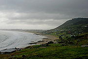
Ahipara
Encyclopedia
New Zealand
New Zealand is an island country in the south-western Pacific Ocean comprising two main landmasses and numerous smaller islands. The country is situated some east of Australia across the Tasman Sea, and roughly south of the Pacific island nations of New Caledonia, Fiji, and Tonga...
. It is at the southern end of Ninety Mile Beach
Ninety Mile Beach, New Zealand
Ninety Mile Beach is a beach located on the western coast of the far north of the North Island of New Zealand. It stretches from just west of Kaitaia towards Cape Reinga along the Aupouri Peninsula. It begins close to the headland of Reef Point, to the west of Ahipara Bay, sweeping briefly...
, with the Tauroa Peninsula to the west and Herekino Forest to the east. Ahipara Bay is to the north west. Kaitaia
Kaitaia
Kaitaia is a town in the far north region of New Zealand, at the base of the Aupouri Peninsula which is about 160 km northwest of Whangarei. It is the last major settlement on the main road north to the capes and bays on the peninsula...
is 14 km to the north east, and Pukepoto
Pukepoto
Pukepoto is a town in Northland, New Zealand. It lies south west of Kaitaia and north east of Ahipara. The Herekino Forest lies to the south east.-Education:...
is between the two.
The population was 1,125 in the 2006 Census, an increase of 84 from 2001.
The name comes from the Māori language
Maori language
Māori or te reo Māori , commonly te reo , is the language of the indigenous population of New Zealand, the Māori. It has the status of an official language in New Zealand...
words ahi, meaning fire, and para, a large fern, and can be translated as "a fire at which para was cooked". Prior to the late 18th century, the area was called Wharo, which means "stretched out". That name originated when the chief Tohe ordered a slave to measure the distance the tide had receded, by counting the number of arm-spans from the high water level.
The area was popular with kauri gum-diggers during the late 19th and early 20th centuries. The Ahipara Gumfields Historic Reserve is to the south of the town.
Shipwreck Bay, at the southern point of Ahipara Bay, contains a number of wrecks visible at low tide.
Ahipara Bay was once well known for its toheroa shellfish, although gathering these is now restricted due to their near-extinction. Both Ahipara and Shipwreck Bays are popular surfing spots.
Education
Ahipara School is a coeducational full primary (years 1-8) school with a decile ratingSocio-Economic Decile
Decile, Socio-Economic Decile or Socio-Economic Decile Band is a widely used measure in education in New Zealand used to target funding and support to more needy schools....
of 3 and a roll of 241. The school was founded in 1872 as a mission school, and moved to its present site in 1901.