

Agüero Point
Encyclopedia
Ioannes Paulus II Peninsula
Ioannes Paulus II Peninsula is an ice-covered peninsula on the north coast of Livingston Island in the South Shetland Islands, Antarctica that is bounded by Hero Bay to the east and Barclay Bay to the west. It extends 13 km in length in north-south direction and is 8 km wide...
into Hero Bay
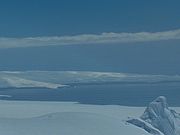
Hero Bay
Hero Bay is a 17 mi wide bay, which indents for 6 mi the north side of Livingston Island between Cape Shirreff and Williams Point, in the South Shetland Islands. The name ‘Blythe Bay’, originally applied to a small bay on the southeast side of Desolation Island on Powell's chart of 1822...
, Livingston Island in the South Shetland Islands
South Shetland Islands
The South Shetland Islands are a group of Antarctic islands, lying about north of the Antarctic Peninsula, with a total area of . By the Antarctic Treaty of 1959, the Islands' sovereignty is neither recognized nor disputed by the signatories and they are free for use by any signatory for...
, Antarctica. The point forms the south side of the entrance to Stoyanov Cove
Stoyanov Cove
Stoyanov Cove is the 2.6 km wide cove indenting for 1.1 km the north coast of Livingston Island in the South Shetland Islands, Antarctica. Entered between Sandanski Point and Agüero Point...
and the north side of the entrance to Prisoe Cove
Prisoe Cove
Prisoe Cove is the 3.7 km wide cove indenting for 1.75 km the north coast of Livingston Island in the South Shetland Islands, Antarctica. Entered between Agüero Point and Avitohol Point...
, and separates the termini
Glacier terminus
A glacier terminus, or snout, is the end of a glacier at any given point in time. Although glaciers seem motionless to the observer, in reality glaciers are in endless motion and the glacier terminus is always either advancing or retreating...
of Urdoviza Glacier
Urdoviza Glacier
Urdoviza Glacier is a glacier bounded by the eastern slopes of Oryahovo Heights on Livingston Island in the South Shetland Islands, Antarctica and draining eastwards into Stoyanov Cove of Hero Bay between Agüero Point and Sandanski Point. The glacier extends 2.8 km in the east-west direction...
to the north from Medven Glacier
Medven Glacier
Medven Glacier is a 2.5 km long and 1.5 km wide glacier bounded by the east slopes of Oryahovo Heights on Ioannes Paulus II Peninsula, Livingston Island in the South Shetland Islands, Antarctica and draining eastwards into Prisoe Cove, Hero Bay between Remetalk Point and Agüero Point.The...
to the south.
The feature is named after Clodomiro Agüero Soto, a crewman of the Chile
Chile
Chile ,officially the Republic of Chile , is a country in South America occupying a long, narrow coastal strip between the Andes mountains to the east and the Pacific Ocean to the west. It borders Peru to the north, Bolivia to the northeast, Argentina to the east, and the Drake Passage in the far...
an naval vessel Yelcho which rescued the Ernest Shackleton
Ernest Shackleton
Sir Ernest Henry Shackleton, CVO, OBE was a notable explorer from County Kildare, Ireland, who was one of the principal figures of the period known as the Heroic Age of Antarctic Exploration...
's expedition fellows members from Elephant Island in 1916.
Location
The point is located at 62°32′24"S 60°40′43"W which is 6.3 km south by east of Black PointBlack Point (Antarctica)
Black Point is a rocky promontory of projecting 800 m northwards from the northeast coast of Ioannes Paulus II Peninsula into Hero Bay, Livingston Island in the South Shetland Islands, Antarctica to form the east side of the entrance to Porlier Bay...
and 3.9 km north-northwest of Avitohol Point
Avitohol Point
Avitohol Point is a point on the north coast of Livingston Island, Antarctica projecting 1.15 km into Hero Bay to form the west side of the entrance to Skravena Cove and the southeast side of the entrance to Prisoe Cove...
(British mapping in 1968, Chilean in 1971, Argentine in 1980, Spanish in 1991, and Bulgarian in 2005 and 2009).
Maps
- L.L. Ivanov et al. Antarctica: Livingston Island and Greenwich Island, South Shetland Islands. Scale 1:100000 topographic map. Sofia: Antarctic Place-names Commission of Bulgaria, 2005.
- L.L. Ivanov. Antarctica: Livingston Island and Greenwich, Robert, Snow and Smith Islands. Scale 1:120000 topographic map. Troyan: Manfred Wörner Foundation, 2009. ISBN 978-954-92032-6-4