Ioannes Paulus II Peninsula
Encyclopedia


Bulgarian language
Bulgarian is an Indo-European language, a member of the Slavic linguistic group.Bulgarian, along with the closely related Macedonian language, demonstrates several linguistic characteristics that set it apart from all other Slavic languages such as the elimination of case declension, the...
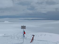
Полуостров Йоан Павел II Poluostrov Yoan Pavel II poluˈɔstrov joˈan ˈpaveɫ fˈtɔri) is an ice-covered peninsula on the north coast of Livingston Island in the South Shetland Islands
South Shetland Islands
The South Shetland Islands are a group of Antarctic islands, lying about north of the Antarctic Peninsula, with a total area of . By the Antarctic Treaty of 1959, the Islands' sovereignty is neither recognized nor disputed by the signatories and they are free for use by any signatory for...
, Antarctica that is bounded by Hero Bay
Hero Bay
Hero Bay is a 17 mi wide bay, which indents for 6 mi the north side of Livingston Island between Cape Shirreff and Williams Point, in the South Shetland Islands. The name ‘Blythe Bay’, originally applied to a small bay on the southeast side of Desolation Island on Powell's chart of 1822...
to the east and Barclay Bay
Barclay Bay
Barclay Bay is a bay lying between Cape Shirreff and Essex Point on the north side of Livingston Island, in the South Shetland Islands. The name appears on an 1825 chart of the British sealing expedition under James Weddell, and is now established in international usage.-Maps:* L.L. Ivanov et al....
to the west. It extends 13 km in length in north-south direction and is 8 km wide. Its north extremity is formed by the ice-free Cape Shirreff
Cape Shirreff
Cape Shirreff is a prominent cape at the north end of the rocky peninsula which separates Hero Bay and Barclay Bay on the north coast of Livingston Island, in the South Shetland Islands...
, an area visited by early 19th century sealers
Seal hunting
Seal hunting, or sealing, is the personal or commercial hunting of seals. The hunt is currently practiced in five countries: Canada, where most of the world's seal hunting takes place, Namibia, the Danish region of Greenland, Norway and Russia...
. The peninsula's interior is occupied by Oryahovo Heights
Oryahovo Heights
Oryahovo Heights are the ice-covered heights of elevation 340 m extending 6 km in north-south direction in central and eastern Ioannes Paulus II Peninsula, Livingston Island in the South Shetland Islands, Antarctica...
.
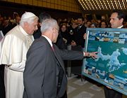
The feature is named after Pope John Paul II
Pope John Paul II
Blessed Pope John Paul II , born Karol Józef Wojtyła , reigned as Pope of the Catholic Church and Sovereign of Vatican City from 16 October 1978 until his death on 2 April 2005, at of age. His was the second-longest documented pontificate, which lasted ; only Pope Pius IX ...
(1920–2005) for his contribution to world peace and understanding among people.
Location
The peninsula is located at 62°31′43"S 60°45′58"W (British mapping in 1822 and 1968, Chilean in 1971, Argentine in 1980, Spanish mapping in 1991, and Bulgarian topographic survey Tangra 2004/05Tangra 2004/05
The Tangra 2004/05 Expedition was commissioned by the Antarctic Place-names Commission at the Ministry of Foreign Affairs of Bulgaria, managed by the Manfred Wörner Foundation, and supported by the Bulgarian Antarctic Institute, the Institute of Mathematics and Informatics at the Bulgarian Academy...
and mapping in 2005 and 2009).
Maps
- L.L. Ivanov et al. Antarctica: Livingston Island and Greenwich Island, South Shetland Islands. Scale 1:100000 topographic map. Sofia: Antarctic Place-names Commission of Bulgaria, 2005.
- L.L. Ivanov. Antarctica: Livingston Island and Greenwich, Robert, Snow and Smith Islands. Scale 1:120000 topographic map. Troyan: Manfred Wörner Foundation, 2009. ISBN 978-954-92032-6-4

