

Aesica
Encyclopedia
Aesica was a Roman
fort
, one and a half miles north of the small town of Haltwhistle
in Northumberland
. It was the ninth fort on Hadrian's Wall
, between Vercovicium (Housesteads) to the east and Magnis (Carvoran) to the west. Its purpose was to guard the Caw Gap, where the Haltwhistle Burn
crosses the Wall. The B6318 Military Road passes about half a mile to the south of the fort.
43 had already been built in preparation for the broad wall, and it is thought that it was the presence of this milecastle that prevented the north wall of the fort being built on the original foundations. It appears that the milecastle was demolished once the fort had been completed. The east gate and east wall cannot now be traced.
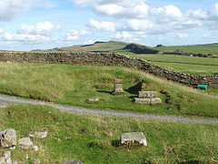
The fort was an oblong, measuring 355 feet (108.2 m) north to south by 419 feet (127.7 m) east to west, occupying a comparatively small area of 3 acres (12,140.6 m²). The north-east corner of the fort is now occupied by farm buildings, built over the route of the Wall.
The fort had only three main gates; south, east and west, with double portals with towers. At some time the west gate was completely blocked up. There were towers at each corner of the fort. The military way entered by the east gate and left by the west gate. A branch road from the Stanegate
entered by the south gate.
The Vallum
passed some short distance south of the fort, and was crossed by a road leading from the south gate to the Stanegate
. A vicus
lay to the south and east of the fort, and several tombstones have been found there.
The fort was supplied by water from a aqueduct
, which wound six miles (10 km) from the head of the Haltwhistle Burn, north of the Wall.
 The 2nd-century garrison was the Sixth Cohort of Nervians
, followed by the Sixth Cohort of Raetia
ns. The 3rd-century garrison was the Second Cohort of Asturians with a detachment of Raeti Gaeseti.
, a silver collar with a pendant, a gold ring and a bronze ring with a Gnostic
gem. During this excavation the headquarters building (principia) was partially uncovered, together with its vaulted underground strong room. A barrack block was also found to the south-west of the principia.
In 1897 a bathhouse was discovered, 100 yards (91.4 m) to the south, east of the branch road to the Stanegate. It includes a dressing room, latrine, cold room with cold bath, dry-heat room, warm steamy room and hot steamy room.
Ancient Rome
Ancient Rome was a thriving civilization that grew on the Italian Peninsula as early as the 8th century BC. Located along the Mediterranean Sea and centered on the city of Rome, it expanded to one of the largest empires in the ancient world....
fort
Castra
The Latin word castra, with its singular castrum, was used by the ancient Romans to mean buildings or plots of land reserved to or constructed for use as a military defensive position. The word appears in both Oscan and Umbrian as well as in Latin. It may have descended from Indo-European to Italic...
, one and a half miles north of the small town of Haltwhistle
Haltwhistle
Haltwhistle is a small town and civil parish in Northumberland, England, situated east of Brampton, near Hadrian's Wall, and the villages of Plenmeller, Rowfoot and Melkridge...
in Northumberland
Northumberland
Northumberland is the northernmost ceremonial county and a unitary district in North East England. For Eurostat purposes Northumberland is a NUTS 3 region and is one of three boroughs or unitary districts that comprise the "Northumberland and Tyne and Wear" NUTS 2 region...
. It was the ninth fort on Hadrian's Wall
Hadrian's Wall
Hadrian's Wall was a defensive fortification in Roman Britain. Begun in AD 122, during the rule of emperor Hadrian, it was the first of two fortifications built across Great Britain, the second being the Antonine Wall, lesser known of the two because its physical remains are less evident today.The...
, between Vercovicium (Housesteads) to the east and Magnis (Carvoran) to the west. Its purpose was to guard the Caw Gap, where the Haltwhistle Burn
Haltwhistle Burn
The Haltwhistle Burn is a river which lies to the east of the Northumbrian town of Haltwhistle. Rising in the peaty uplands below the ridge of the Whin Sill, the burn passes through the Roman Military Zone south of Hadrian's Wall and through a dramatic sandstone gorge before descending between...
crosses the Wall. The B6318 Military Road passes about half a mile to the south of the fort.
Description
It is believed that the fort was completed in the year 128 AD. Unlike other wall forts that project beyond the Wall, all of Aesica is south of the Wall. The Wall at this point is narrow gauge, but stands next to foundations that were prepared for the broad wall. There was speculation as to why the foundations for the broad wall had not been used to support the wall at this point. In 1939 it was found that milecastleMilecastle
A milecastle was a small fort , a rectangular fortification built during the period of the Roman Empire. They were placed at intervals of approximately one Roman mile along several major frontiers, for example Hadrian's Wall in Great Britain , hence the name.Along Hadrian's Wall, milecastles were...
43 had already been built in preparation for the broad wall, and it is thought that it was the presence of this milecastle that prevented the north wall of the fort being built on the original foundations. It appears that the milecastle was demolished once the fort had been completed. The east gate and east wall cannot now be traced.
The fort was an oblong, measuring 355 feet (108.2 m) north to south by 419 feet (127.7 m) east to west, occupying a comparatively small area of 3 acres (12,140.6 m²). The north-east corner of the fort is now occupied by farm buildings, built over the route of the Wall.
The fort had only three main gates; south, east and west, with double portals with towers. At some time the west gate was completely blocked up. There were towers at each corner of the fort. The military way entered by the east gate and left by the west gate. A branch road from the Stanegate
Stanegate
The Stanegate, or "stone road" , was an important Roman road built in what is now northern England. It linked two forts that guarded important river crossings; Corstopitum in the east, situated on Dere Street, and Luguvalium in the west...
entered by the south gate.
The Vallum
Vallum
Vallum is a term applied either to the whole or a portion of the fortifications of a Roman camp. The vallum usually comprised an earthen or turf rampart with a wooden palisade on top, with a deep outer ditch...
passed some short distance south of the fort, and was crossed by a road leading from the south gate to the Stanegate
Stanegate
The Stanegate, or "stone road" , was an important Roman road built in what is now northern England. It linked two forts that guarded important river crossings; Corstopitum in the east, situated on Dere Street, and Luguvalium in the west...
. A vicus
Vicus (Rome)
In ancient Rome, the vicus was a neighborhood. During the Republican era, the four regiones of the city of Rome were subdivided into vici. In the 1st century BC, Augustus reorganized the city for administrative purposes into 14 regions, comprising 265 vici. Each vicus had its own board of...
lay to the south and east of the fort, and several tombstones have been found there.
The fort was supplied by water from a aqueduct
Aqueduct
An aqueduct is a water supply or navigable channel constructed to convey water. In modern engineering, the term is used for any system of pipes, ditches, canals, tunnels, and other structures used for this purpose....
, which wound six miles (10 km) from the head of the Haltwhistle Burn, north of the Wall.
Garrison
Nervii
The Nervii were an ancient Germanic tribe, and one of the most powerful Belgic tribes; living in the northeastern hinterlands of Gaul, they were known to trek long distances to engage in various wars and functions...
, followed by the Sixth Cohort of Raetia
Raetia
Raetia was a province of the Roman Empire, named after the Rhaetian people. It was bounded on the west by the country of the Helvetii, on the east by Noricum, on the north by Vindelicia, on the west by Cisalpine Gaul and on south by Venetia et Histria...
ns. The 3rd-century garrison was the Second Cohort of Asturians with a detachment of Raeti Gaeseti.
Excavations
Excavations were carried out in 1894, during which the ramparts were cleared. The west tower of the south gate was found to contain a hoard of jewellery, which included an enamelled brooch shaped as a hare, a gilded bronze brooch described as a masterpiece of Celtic artCeltic art
Celtic art is the art associated with the peoples known as Celts; those who spoke the Celtic languages in Europe from pre-history through to the modern period, as well as the art of ancient peoples whose language is uncertain, but have cultural and stylistic similarities with speakers of Celtic...
, a silver collar with a pendant, a gold ring and a bronze ring with a Gnostic
Gnosticism
Gnosticism is a scholarly term for a set of religious beliefs and spiritual practices common to early Christianity, Hellenistic Judaism, Greco-Roman mystery religions, Zoroastrianism , and Neoplatonism.A common characteristic of some of these groups was the teaching that the realisation of Gnosis...
gem. During this excavation the headquarters building (principia) was partially uncovered, together with its vaulted underground strong room. A barrack block was also found to the south-west of the principia.
In 1897 a bathhouse was discovered, 100 yards (91.4 m) to the south, east of the branch road to the Stanegate. It includes a dressing room, latrine, cold room with cold bath, dry-heat room, warm steamy room and hot steamy room.
External links
- AESICA at www.Roman-Britain.org
- AESICA FORT at hadrianswallcamera.co.uk