
Acheloos River
Encyclopedia
River
A river is a natural watercourse, usually freshwater, flowing towards an ocean, a lake, a sea, or another river. In a few cases, a river simply flows into the ground or dries up completely before reaching another body of water. Small rivers may also be called by several other names, including...
in western Greece
Greece
Greece , officially the Hellenic Republic , and historically Hellas or the Republic of Greece in English, is a country in southeastern Europe....
. It formed the boundary between Acarnania
Acarnania
Acarnania is a region of west-central Greece that lies along the Ionian Sea, west of Aetolia, with the Achelous River for a boundary, and north of the gulf of Calydon, which is the entrance to the Gulf of Corinth. Today it forms the western part of the prefecture of Aetolia-Acarnania. The capital...
and Aetolia
Aetolia
Aetolia is a mountainous region of Greece on the north coast of the Gulf of Corinth, forming the eastern part of the modern prefecture of Aetolia-Acarnania.-Geography:...
of antiquity. It empties into the Ionian Sea
Ionian Sea
The Ionian Sea , is an arm of the Mediterranean Sea, south of the Adriatic Sea. It is bounded by southern Italy including Calabria, Sicily and the Salento peninsula to the west, southern Albania to the north, and a large number of Greek islands, including Corfu, Zante, Kephalonia, Ithaka, and...
. In ancient times its spirit was venerated as the river god Achelous
Achelous
In Greek mythology, Achelous was the patron deity of the "silver-swirling" Achelous River, which is the largest river of Greece, and thus the chief of all river deities, every river having its own river spirit. His name is pre-Greek, its meaning unknown...
.
Herodotus
Herodotus
Herodotus was an ancient Greek historian who was born in Halicarnassus, Caria and lived in the 5th century BC . He has been called the "Father of History", and was the first historian known to collect his materials systematically, test their accuracy to a certain extent and arrange them in a...
, taking notice of the shoreline-transforming power of the Acheloos River, even compared it to the Nile
Nile
The Nile is a major north-flowing river in North Africa, generally regarded as the longest river in the world. It is long. It runs through the ten countries of Sudan, South Sudan, Burundi, Rwanda, Democratic Republic of the Congo, Tanzania, Kenya, Ethiopia, Uganda and Egypt.The Nile has two major...
in this respect:
- 'There are other rivers as well which, though not as large as the Nile, have had substantial results. In particular (although I could name others), there is the Achelous, which flows through AcarnaniaAcarnaniaAcarnania is a region of west-central Greece that lies along the Ionian Sea, west of Aetolia, with the Achelous River for a boundary, and north of the gulf of Calydon, which is the entrance to the Gulf of Corinth. Today it forms the western part of the prefecture of Aetolia-Acarnania. The capital...
into the sea and has already turned half the Echinades islands into mainland.' (2.10, trans. Waterfield)
The previous name was Thoas. It is rarely known as Thestios and Axenos.
Course
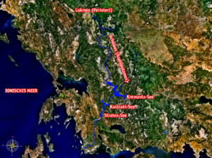
The river Achelous begins at about 2000 metres (6,561.7 ft) elevation on the eastern slope of LakmosLakmos
Lakma or Lakmos is a mountain in eastern Ioannina and western Trikala prefectures. The mountain is a part of the Pindus mountain range. Its maximum elevation is 2,295 m and is named Tsoukarela...
mountain in the Pindus
Pindus
The Pindus mountain range is located in northern Greece and southern Albania. It is roughly 160 km long, with a maximum elevation of 2637 m . Because it runs along the border of Thessaly and Epirus, the Pindus range is often called the "spine of Greece"...
range, near the village Milea in the Trikala Prefecture
Trikala Prefecture
Trikala is one of the regional units of Greece. It is part of the region of Thessaly. Its capital is the town of Trikala. The regional unit includes the town of Kalampaka and the Meteora monastery complex.-Geography:...
. One of its first tributaries is the Aspropotamos, meaning the white
White
White is a color, the perception of which is evoked by light that stimulates all three types of color sensitive cone cells in the human eye in nearly equal amounts and with high brightness compared to the surroundings. A white visual stimulation will be void of hue and grayness.White light can be...
river
River
A river is a natural watercourse, usually freshwater, flowing towards an ocean, a lake, a sea, or another river. In a few cases, a river simply flows into the ground or dries up completely before reaching another body of water. Small rivers may also be called by several other names, including...
.
The river flows generally southwards, and forms part of the boundary between the prefectures of Arta
Arta Prefecture
Arta is one of the regional units of Greece. It is part of the Epirus region. Its capital is the town of Arta.-Geography:The regional unit of Arta is located north of the Ambracian Gulf. The main mountain ranges are the Athamanika in the northeast, the Pindus in the east, and Valtou in the...
and Trikala, which is also the boundary between Epirus
Epirus (periphery)
Epirus , formally the Epirus Region , is a geographical and administrative region in northwestern Greece. It borders the regions of West Macedonia and Thessaly to the east, West Greece to the south, the Ionian Sea and the Ionian Islands to the west and the country of Albania to the north. The...
and Thessaly
Thessaly
Thessaly is a traditional geographical region and an administrative region of Greece, comprising most of the ancient region of the same name. Before the Greek Dark Ages, Thessaly was known as Aeolia, and appears thus in Homer's Odyssey....
. Further downstream, it forms the boundary of Arta and Karditsa Prefecture
Karditsa Prefecture
Karditsa is one of the regional units of Greece. It is part of the region of Thessaly. Its name is derived from its capital Karditsa, a small city of approximately 35,000 people.-Geography:...
, and further of Aetolia-Acarnania
Aetolia-Acarnania
Aetolia-Acarnania is one of the regional units of Greece. It is part of the region of West Greece. It is located in the western part of Greece; the regional unit is a combination of the geographic regions Aetolia and Acarnania. Its capital is Missolonghi for historical reasons, with its biggest...
and Eurytania. The river runs into the Kremasta
Kremasta (lake)
Lake Kremasta is the largest artificial lake in Greece. The construction of the dam of Kremasta was completed in 1969 concentrating waters from four rivers: Acheloos, Agrafiotis, Tavropos and Trikeriotis. The water that is accumulated in the artificial lake is about 4,700,000,000 m³...
reservoir, which is also fed by the rivers Agrafiotis
Agrafiotis
The Agrafiotis River is a river/stream that flows entirely in the Evrytania prefecture in Greece. The river owes its name to Agrafa, the mountainous region where it flows. The river begins in the North of the prefecture and passes into a valley filled with only traces of farmlands, beautiful pine...
and Megdovas.
On exiting the Kremasta reservoir, the river flows southwest into Aetolia-Acarnania, feeding the Kastraki
Kastraki (lake)
Lake Kastraki is an artificial lake in Greece. It is located east of Kastraki and Babalio in the Aitoloakarnania prefecture. It dams up the Acheloos. The area is about 28 km² and has about 1,000,000 m² of water...
reservoir, west of the Panaitoliko
Panaitoliko
Panaitoliko is a former municipality in Aetolia-Acarnania, West Greece, Greece. Since the 2011 local government reform it is part of the municipality Agrinio, of which it is a municipal unit. Population 1,853 . The seat of the municipality was in Skoutera....
range. 10 to 15 kilometres (9.3 mi) downstream from this lake, it flows into the Stratos
Stratos (lake)
Lake Stratou is an artificial lake in Greece. It is located near Stratos near a pond in which the GR-5/E55 viaduct is nearly located. The lake's has a minimum of 60,000,000 m³ of water and the maximum is 70,200,000 m³...
reservoir. Further downstream, it runs west of Agrinio
Agrinio
Agrinion is the largest city and municipality of the Aetolia-Acarnania peripheral unit of Greece, with 96,321 inhabitants. It is the economical center of Aetolia-Acarnania, although its capital is the town of Mesolonghi. The settlement dates back to ancient times...
and into swamplands and forests. It is crossed by a 2 kilometres (1.2 mi) long bridge of GR-5
Greek National Road 5
Greek National Road 5 is a highway in Western Greece. It runs from 2 km south of Rio at GR-8/GR-9 , or at the beginning of the Patras By-Pass in the south up to the city centre of Ioannina. It is now connected with a new bridge, the Rio-Antirio bridge and for 5 km is a joint with GR-48...
/E55
European route E55
European route E 55 is a E-route. It passes through the following cities:Helsingborg … Helsingør – Copenhagen – Køge – Vordingborg – Nykøbing Falster – Gedser … Rostock – Berlin – Lübbenau – Dresden – Teplice – Prague – Tábor – Linz – Salzburg – Villach – Tarvisio – Udine – Palmanova – Mestre...
(Ioannina - Antirio). It finally empties into the Ionian Sea
Ionian Sea
The Ionian Sea , is an arm of the Mediterranean Sea, south of the Adriatic Sea. It is bounded by southern Italy including Calabria, Sicily and the Salento peninsula to the west, southern Albania to the north, and a large number of Greek islands, including Corfu, Zante, Kephalonia, Ithaka, and...
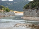
, west of Messolongi. The river has some canyons.
History
In 1359 the Battle of AchelousBattle of Achelous (1359)
The Battle of Achelous took place in 1359 near the river Achelous, in Aetolia, modern Greece fought between Albanian troops, under Peter Losha, and forces of the Despotate of Epirus, under Nikephoros II Orsini. The Albanians defeated Orsini's army, which suffered massive casualties during the battle...
between Albanian
Albanians
Albanians are a nation and ethnic group native to Albania and neighbouring countries. They speak the Albanian language. More than half of all Albanians live in Albania and Kosovo...
forces under Peter Losha
Peter Losha
Peter Losha was a 14th-century Albanian despot of Despotate of Arta from 1359 to his death in 1374 under Simeon Uroš.In 1346-1348 Epirus became a part of the Serbian Empire and Albanian tribes were defeated by Stefan Dushan....
and the Despotate of Epirus
Despotate of Epirus
The Despotate or Principality of Epirus was one of the Byzantine Greek successor states of the Byzantine Empire that emerged in the aftermath of the Fourth Crusade in 1204. It claimed to be the legitimate successor of the Byzantine Empire, along with the Empire of Nicaea, and the Empire of Trebizond...
under Nikephoros II Orsini
Nikephoros II Orsini
Nikephoros II Orsini - Doukas , was the ruler of Epirus from 1335 to 1338 and from 1356 until his death in 1359.-Life:...
took place near the river Achelous. Nikephoros II was defeated and killed during the battle, and two new states were established in the area the Despotate of Arta
Despotate of Arta
The Despotate of Arta was a despotate established by Albanian rulers during the 14th century, when Albanian tribes moved into Epirus and founded two short-lived principalities there...
and the Despotate of Angelokastron and Lepanto
Despotate of Angelokastron and Lepanto
The Despotate of Angelokastron and Lepanto was a short-lived despotate ruled by the Albanian chieftain Gjin Bua Shpata, in the late medieval period including parts of Western Greece. It was created after the defeat of Nikephoros II Orsini, Despot of Epirus in the Battle of Achelous, in 1359 and...
.
In the 1960s, the dam project
Stratos Hydroelectric Dam
The Stratos Hydroelectric Dam is a dam that dams up the Acheloos River just east of Stratos and north of the GR-5/E55 .-History:...
in the Aitoloacarnania-Evrytania boundary was under construction. The area is not forested. The dam was under construction and the type is a concrete dam. It took years to complete and the flooding of the portion of the western part of the prefecture of Eurytania began. The dam includes a power station with transformer lines in the east. The dam powers electricity for the western part of Greece and the central part. It caused some soil erosion in some flooded valleys. Another dam which is named the Katsiki Dam is downstream. The arch bridges includes the Karafilio and the Ardanovo.
Places
In order from upstream to downstream:- Milea
- Agia Paraskevi
- GR-30Greek National Road 30The Greek National Road 30 is a highway or route that links the cities of Volos, Karditsa, Trikala and Arta.-Information:...
- east of GardikiGardiki (Trikala), Greece-History:Cardica is a Latinized medieval form for Gardicium, the true ancient Greek name being Gardikion. Cardica is its name as a Roman Catholic titular see in the former Roman province of Thessaly....
- Polyneri
- AgrinioAgrinioAgrinion is the largest city and municipality of the Aetolia-Acarnania peripheral unit of Greece, with 96,321 inhabitants. It is the economical center of Aetolia-Acarnania, although its capital is the town of Mesolonghi. The settlement dates back to ancient times...
- Fragouleika
- AitolikoAitolikoAitoliko is a town and a former municipality in Aetolia-Acarnania, West Greece, Greece. Since the 2011 local government reform it is part of the municipality Messolonghi, of which it is a municipal unit. It is located north of the Acheloos delta. The Greek National Road 5/E55 passes through the...
- west of MessolonghiMessolonghiMissolonghi is a town of 12,225 people in western Greece. The town is the capital of Aetolia-Acarnania and is also its third largest town. It is the seat of the municipality of Iera Poli Mesolongiou . Missolonghi is linked to, although bypassed since the 1960s by, GR-5/E55...
External links
- http://www.water-technology.net/projects/acheloos
- Ancient Greece Iconography at BeazleyJohn BeazleySir John Davidson Beazley was an English classical scholar.Born in Glasgow, Scotland, Beazley attended Balliol College, Oxford, where he was a close friend of the poet James Elroy Flecker. After graduating in 1907, Beazley was a student and tutor in Classics at Christ Church, and in 1925 he...
Archive (Oxford University) - http://www.bartleby.com/65/ak/Akheloos.html - Columbia EncyclopediaColumbia EncyclopediaThe Columbia Encyclopedia is a one-volume encyclopedia produced by Columbia University Press and sold by the Gale Group. First published in 1935, and continuing its important relationship with Columbia University, the encyclopedia underwent major revisions in 1950 and 1963; the current edition is...
- http://www.geocities.com/sjogurka/akheloos.html (Archived 2009-10-24)
- http://encarta.msn.com/encyclopedia_761580324/Akheloos.html (Archived 2009-10-31) - MSN EncartaEncartaMicrosoft Encarta was a digital multimedia encyclopedia published by Microsoft Corporation from 1993 to 2009. , the complete English version, Encarta Premium, consisted of more than 62,000 articles, numerous photos and illustrations, music clips, videos, interactive contents, timelines, maps and...
- http://reference.allrefer.com/encyclopedia/A/Akheloos.html
- Ecoguides on Achelous
- TV2 Travel Channel on Achelous
- Aspropotamos River
- http://www.vourgarelinet.gr/axioth/aheloos/aheloos.htm (in Greek)
- http://www.evrytan.gr/up0/Ta_Potamia_mas1.htm (in Greek)
- http://www.tee.gr/online/epikaira/2000/2123/pg026.shtml (in Greek)
- http://www.aspropotamos.com/aspros-history.htm (in Greek)
- http://www.trikalasport.gr/exormisis/prin2003/axeloos.html (in Greek) - Trikalasport.gr
- http://www.kliafas.com/aspros0.htm (in Greek)
- http://books.google.com/books?id=03fC3lCOGlsC&pg=PA328&dq=Stratos+Hydroelectric+Dam&hl=en&ei=DlvxS5r4NcL88AbIp7H-Cg&sa=X&oi=book_result&ct=book-thumbnail&resnum=1&ved=0CC0Q6wEwAA#v=onepage&q=Stratos%20Hydroelectric%20Dam&f=false