
A628 road
Encyclopedia
The A628 is a major road in the north of England
connecting Greater Manchester
and South Yorkshire
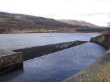
by crossing the Pennine chain of hills by way of the Woodhead Pass through the Peak District National Park. The height and the exposure of the road often creates problems during poor weather in winter and the road is sometimes closed due to snowfall or high winds. There are plans for a bypass around Mottram in Longdendale
, Hollingworth
and Tintwistle
.
at the end of the M67 motorway
and A57 road
. It currently passes through Mottram in Longdendale
, Hollingworth
and Tintwistle
(where there are plans for a bypass see Longdendale Bypass
) and then up through the valley of Longdendale
and the Peak District National Park to Crowden
to Salter's Brook Bridge. From the summit the road descends through Millhouse Green
, Thurlstone
, around Penistone
joining the M1 motorway
at Junction 37.
From the M1 junction to road passes through Barnsley
, Cudworth
, Brierley
and around Hemsworth
(bypassed) to Ackworth Moor Top ending to Pontefract
at a junction with the A639 road.
The height and the exposure of the road over the Woodhead Pass creates problems during poor weather in winter when the road can be closed due to snowfall or high winds.
track "The Snake", which suggests it as an alternative route from the M62
or Snake Pass
.
England
England is a country that is part of the United Kingdom. It shares land borders with Scotland to the north and Wales to the west; the Irish Sea is to the north west, the Celtic Sea to the south west, with the North Sea to the east and the English Channel to the south separating it from continental...
connecting Greater Manchester
Greater Manchester
Greater Manchester is a metropolitan county in North West England, with a population of 2.6 million. It encompasses one of the largest metropolitan areas in the United Kingdom and comprises ten metropolitan boroughs: Bolton, Bury, Oldham, Rochdale, Stockport, Tameside, Trafford, Wigan, and the...
and South Yorkshire
South Yorkshire
South Yorkshire is a metropolitan county in the Yorkshire and the Humber region of England. It has a population of 1.29 million. It consists of four metropolitan boroughs: Barnsley, Doncaster, Rotherham, and City of Sheffield...
by crossing the Pennine chain of hills by way of the Woodhead Pass through the Peak District National Park. The height and the exposure of the road often creates problems during poor weather in winter and the road is sometimes closed due to snowfall or high winds. There are plans for a bypass around Mottram in Longdendale
Mottram in Longdendale
Mottram in Longdendale is an unparished village within the Metropolitan Borough of Tameside, in Greater Manchester, England. It lies in the valley of Longdendale, on the border with Derbyshire and close to the Peak District neighbouring Broadbottom and Hattersley. Mottram in Longdendale Parish was...
, Hollingworth
Hollingworth
Hollingworth is a village within the Metropolitan Borough of Tameside, in Greater Manchester, England. It is about twelve miles east of Manchester on the Derbyshire border at Glossop...
and Tintwistle
Tintwistle
Tintwistle is a village and civil parish in the High Peak district of the non-metropolitan county of Derbyshire, England. According to the 2001 census the parish had a population of 1,401. The village is just north of Glossop at the lower end of Longdendale Valley...
.
Route
The road starts to the East of ManchesterManchester
Manchester is a city and metropolitan borough in Greater Manchester, England. According to the Office for National Statistics, the 2010 mid-year population estimate for Manchester was 498,800. Manchester lies within one of the UK's largest metropolitan areas, the metropolitan county of Greater...
at the end of the M67 motorway
M67 motorway
The M67 is a urban motorway in Greater Manchester, England which heads east from the M60 motorway passing through Denton and Hyde before ending near Mottram. It had originally conceived as the first part of a trans-Pennine motorway between Manchester and Sheffield connecting the A57 motorway to...
and A57 road
A57 road
The A57 is a major road in England. It runs east from Liverpool to Lincoln, via Warrington, Cadishead, Irlam, Patricroft, Eccles, Salford and Manchester, then through the Pennines over the Snake Pass , around the Ladybower Reservoir, through Sheffield and past Worksop...
. It currently passes through Mottram in Longdendale
Mottram in Longdendale
Mottram in Longdendale is an unparished village within the Metropolitan Borough of Tameside, in Greater Manchester, England. It lies in the valley of Longdendale, on the border with Derbyshire and close to the Peak District neighbouring Broadbottom and Hattersley. Mottram in Longdendale Parish was...
, Hollingworth
Hollingworth
Hollingworth is a village within the Metropolitan Borough of Tameside, in Greater Manchester, England. It is about twelve miles east of Manchester on the Derbyshire border at Glossop...
and Tintwistle
Tintwistle
Tintwistle is a village and civil parish in the High Peak district of the non-metropolitan county of Derbyshire, England. According to the 2001 census the parish had a population of 1,401. The village is just north of Glossop at the lower end of Longdendale Valley...
(where there are plans for a bypass see Longdendale Bypass
Longdendale Bypass
The Longdendale Bypass was a controversial road scheme in England by the Highways Agency. The aim was to alleviate traffic congestion on the A57 road/A628 road/A616 road routes that presently pass through the villages...
) and then up through the valley of Longdendale
Longdendale
Longdendale is a valley in the north of England, north of Glossop and south east of Holmfirth. The name means "long wooded valley".- Geography :...
and the Peak District National Park to Crowden
Crowden, Derbyshire
Crowden is a landmark hamlet in the High Peak district of Derbyshire, miles northeast of Glossop and miles southwest of Holme in West Yorkshire, as well as from the larger city of Manchester and from the town of Barnsley...
to Salter's Brook Bridge. From the summit the road descends through Millhouse Green
Millhouse Green
Millhouse Green is a village on the north banks of the River Don on the A628 road west of Penistone in the English county of South Yorkshire.Administratively, Millhouse Green forms part of the Metropolitan Borough of Barnsley and Penistone civil parish....
, Thurlstone
Thurlstone
Thurlstone is a village near Penistone in the metropolitan borough of Barnsley in South Yorkshire, England.Originally it was a small farming community. Some industries developed using water power from the River Don...
, around Penistone
Penistone
Penistone is a small town market town and civil parish in the Metropolitan Borough of Barnsley, in South Yorkshire, England, with a population of 10,101 at the 2001 census. It lies west of the town of Barnsley and north east of Glossop, in the foothills of the Pennines...
joining the M1 motorway
M1 motorway
The M1 is a north–south motorway in England primarily connecting London to Leeds, where it joins the A1 near Aberford. While the M1 is considered to be the first inter-urban motorway to be completed in the United Kingdom, the first road to be built to motorway standard in the country was the...
at Junction 37.
From the M1 junction to road passes through Barnsley
Barnsley
Barnsley is a town in South Yorkshire, England. It lies on the River Dearne, north of the city of Sheffield, south of Leeds and west of Doncaster. Barnsley is surrounded by several smaller settlements which together form the Metropolitan Borough of Barnsley, of which Barnsley is the largest and...
, Cudworth
Cudworth, South Yorkshire
Cudworth is a semi-rural village on the outskirts of Barnsley in South Yorkshire, England. Cudworth has a busy village centre surrounded by some housing and green belt countryside...
, Brierley
Brierley
Brierley is a town and civil parish in the Metropolitan Borough of Barnsley in South Yorkshire, England), close to the border with West Yorkshire. It lies to the south-west of Hemsworth, off the A628 road, and is located at approximately 53° 35' 40" North, 1° 23' West, at an elevation of around...
and around Hemsworth
Hemsworth
Hemsworth is a small town and civil parish on the edge of West Yorkshire, England. It forms part of the City of Wakefield, and has a population of 13,311....
(bypassed) to Ackworth Moor Top ending to Pontefract
Pontefract
Pontefract is an historic market town in West Yorkshire, England. Traditionally in the West Riding, near the A1 , the M62 motorway and Castleford. It is one of the five towns in the metropolitan borough of the City of Wakefield and has a population of 28,250...
at a junction with the A639 road.
The height and the exposure of the road over the Woodhead Pass creates problems during poor weather in winter when the road can be closed due to snowfall or high winds.
Proposed developments
The route goes through Longdendale and proposed improvements, the Longdendale Bypass plans, are (as of 2008) a matter of great debate.Culture
The A628 is specifically mentioned in the 2001 Human LeagueThe Human League
The Human League are an English electronic New Wave band formed in Sheffield in 1977. They achieved popularity after a key change in line-up in the early 1980s and have continued recording and performing with moderate commercial success throughout the 1980s up to the present day.The only constant...
track "The Snake", which suggests it as an alternative route from the M62
M62 motorway
The M62 motorway is a west–east trans-Pennine motorway in Northern England, connecting the cities of Liverpool and Hull via Manchester and Leeds. The road also forms part of the unsigned Euroroutes E20 and E22...
or Snake Pass
Snake Pass
The Snake Pass is the name given to the remote, higher reaches of the A57 road where it crosses the Peak District between Manchester and Sheffield in the north of England...
.