

A4135 road
Encyclopedia
Gloucestershire
Gloucestershire is a county in South West England. The county comprises part of the Cotswold Hills, part of the flat fertile valley of the River Severn, and the entire Forest of Dean....
connecting the town of Tetbury
Tetbury
Tetbury is a town and civil parish within the Cotswold district of Gloucestershire, England. It lies on the site of an ancient hill fort, on which an Anglo-Saxon monastery was founded, probably by Ine of Wessex, in 681. The population of the parish was 5,250 in the 2001 census.In the Middle Ages,...
with the M5 motorway
M5 motorway
The M5 is a motorway in England. It runs from a junction with the M6 at West Bromwich near Birmingham to Exeter in Devon. Heading south-west, the M5 runs east of West Bromwich and west of Birmingham through Sandwell Valley...
and the A38 road
A38 road
The A38, part of which is also known as the Devon Expressway, is a major A-class trunk road in England.The road runs from Bodmin in Cornwall to Mansfield in Nottinghamshire. It is long, making it one of the longest A-roads in England. It was formerly known as the Leeds — Exeter Trunk Road,...
to the west, passing through Beverston
Beverston
Beverston is a village and civil parish in the Cotswold district of Gloucestershire, England. According to the 2001 census it had a population of 132. The village is about two miles west of Tetbury. Beverston is an example of a typical unaltered Gloucestershire Cotswold village...
, Dursley
Dursley
Dursley is a market town in Gloucestershire, England. It is under the North East flank of Stinchcombe Hill , and about 6 km South East of the River Severn. The town is adjacent with Cam which, though a village, is a community of double the size...
and Cam
Cam, Gloucestershire
Cam is a large village and civil parish in Gloucestershire, England, situated in the Cotswolds. The Cotswold Way runs less than a mile from the village. It has a boundary with the town of Dursley.Cam had approximately 8,500 residents in the 2001 census...
en route to Slimbridge
Slimbridge
Slimbridge is a village near Dursley in Gloucestershire, England.It is best known as the home of the Wildfowl and Wetlands Trust's Slimbridge Reserve which was started by Sir Peter Scott. The Gloucester and Sharpness Canal runs through the village, and under Patch Bridge which must be crossed to ...
,
In the year 2001 a speed camera was installed at Dursley
Dursley
Dursley is a market town in Gloucestershire, England. It is under the North East flank of Stinchcombe Hill , and about 6 km South East of the River Severn. The town is adjacent with Cam which, though a village, is a community of double the size...
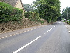
with an associated speed limit zone of 30 miles per hour (13.4 m/s). The image shown (right) depicts a typical stretch of the A4135 road; the dry-stone wall illustrated is of considerable age and may indicate a very early awareness of the ability of stone walls to serve as noise barrier
Noise barrier
A noise barrier is an exterior structure designed to protect sensitive land uses from noise pollution...
s as well as safety barriers.