
A256 road
Encyclopedia
The A256 is a key road
running north-south through East Kent
which connects the Thanet
towns to Dover
.
town of Broadstairs
, at a roundabout with the A255 where it heads westwards through the Westwood Retail Parks via "Westwood Road".
The A256 then passes 2 roundabouts with residential estates on the left before arriving at a couple of smaller roundabouts with exits to the left and right into the various retail parks. Most of these parks were built during the early 2000s.
Also in Westwood, the A256 meets a large roundabout with the A254
Margate Road. Here the A256 heads south-westwards, called 'Haine Road', passing Westwood Cross
shopping centre on the left (built on the former Haine Hospital site) at a roundabout with Manston Court Road (on the right). The A256 then briefly bypasses the village of Haine, along New Haine Road, constructed in early 2009, which heads southeastwards alongside Westwood Cross shopping centre, before heading southwestwards after another roundabout, and passing The Marlowe Academy. At the next roundabout, with the Euro Kent Business Park situated on the left, the A256 then rejoins its original route along Haine Road.
Here, the route of the A256 takes a more southerly direction, travelling in the direction of Sandwich
. The three cooling towers of the disused Richborough Power Station can be seen in the distance, almost straight ahead (weather permitting).
Further along Haine Road the A256 becomes dual carriageway for about 300 metres (0.2 miles) with its junction with the B2050 Manston Road.
 Approximately 600 metres (0.4 miles) after this junction, the A256 encounters a double roundabout junction, known as the "Lord of the Manor" roundabout, named after the pub on the junction. At the first junction there are exits for the A299
(formerly A253
) towards London
and Canterbury
, and for the (joint) A256/A299
towards Ramsgate
and Dover
. A railway line separates the two roundabouts and passes underneath the main dual road A256/A299
, with high white concrete walls on both sides of the road. At the second roundabout has there are exits for the A299
travelling towards Ramsgate
and the A256, travelling southwards, towards Sandwich
. It is here where the A256 becomes a primary route.
Shortly after the Lord of the Manor
roundabout, the A256 Sandwich Road bends to the right, now facing a more south-westerly direction as it enters the village of Cliffsend
. The majority of the built-up area of Cliffsend
is on the western side of the road. The land to the south of the village is relatively flat and low-lying (just 3 metres above sea level). It previously formed the Wantsum Channel
which used to separate the Isle of Thanet
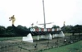
from mainland Kent. The famous Viking Ship 'Hugin' sits on the east side of the A256, separating the road from the sea. St Augustines Golf Club is situated next to the A256 south-west of Cliffsend
. Cliffsend
also forms the boundary on the A256 between Thanet District Council
and Dover District Council.
 The single road then travels through low and flat land, passing Richborough Port, Castle, and disused Power Station. A Subway and petrol stations are also situated on the left-hand and right hand sides of the road, in between the road and Sandwich Bay.
The River Stour
, which previously formed part of the Wantsum Channel
, runs parallel on both sides of Ramsgate Road. At the next roundabout, the original A256 Ramsgate Road leaves the new bypass, and heads towards Sandwich
town centre. The bypass itself continues the route of the A256 in a slow semicircle to the west of the town of Sandwich. The bypass is composed of four roundabouts; the second roundabout has three more exits – the A257 Canterbury Road heading towards Canterbury
, a minor road travelling towards Sandwich town centre (previously the A257 before the bypass was built) and the A256 bypass travelling southwards towards Dover
. At the third roundabout of the Sandwich bypass, there are three more exits – the former A256 towards Sandwich, the A258
(which actually continues the Sandwich bypass for a further 0.3 miles) towards Deal
, and the A256 Sandwich Road towards Dover. Here the A256 changes to a south-westerly direction, briefly bypassing the village of Eastry
for approximately 1.4 miles (2.3 km).
, whilst the current A256 dual carriageway diverts on a more easterly journey. Approximately 1.8 miles (2.9 km) further south from this junction is a roundabout where the old A256 one again rejoins the dual carriageway – there is also a minor road on the left heads towards East Studdal
.
Shortly after this roundabout, the A256 splits once again and continues on a dual carriageway bypass whilst the former A256 Sandwich Road travels through the village of Whitfield
before arriving at a large roundabout south of Whitfield
, with the A2
.
The current A256 dual carriageway actually arrives at a junction with the A2
dual carriageway a further 0.4 mile (0.643736 km) to the east, where the A2
and A256 merge together and travel westwards for 700 metres until the roundabout at Whitfield.
This is where the A256 loses its primary route status and also becomes a single road, travelling south westwards briefly for (approximately) 0.6 miles, before turning left onto London Road, heading towards Dover
town centre in a south-easterly direction. Roughly 0.6 mile (0.965604 km) along London Road and the A256 enters the built up area of Buckland
and travels downhill towards Dover
.
Soon after passing underneath a railway bridge, a one-way system is encountered where the road number A256 is given to both Buckland Avenue and London Road which form part of the one-way system.
Eventually, after meeting the A258
once again on the downhill part of the one-way system, the A256 terminates on the A20 Townwall Street, which runs parallel to the coastline, north-eastwards towards the A2
Jubilee Way and south-westwards towards Folkestone and the M20 motorway
.
Road
A road is a thoroughfare, route, or way on land between two places, which typically has been paved or otherwise improved to allow travel by some conveyance, including a horse, cart, or motor vehicle. Roads consist of one, or sometimes two, roadways each with one or more lanes and also any...
running north-south through East Kent
East Kent
East Kent and West Kent are one-time traditional subdivisions of the English county of Kent, kept alive by the Association of the Men of Kent and Kentish Men: an organisation formed in 1913...
which connects the Thanet
Thanet
Thanet is a local government district of Kent, England which was formed under the Local Government Act 1972, and came into being on 1 April 1974...
towns to Dover
Dover
Dover is a town and major ferry port in the home county of Kent, in South East England. It faces France across the narrowest part of the English Channel, and lies south-east of Canterbury; east of Kent's administrative capital Maidstone; and north-east along the coastline from Dungeness and Hastings...
.
Thanet
The road begins in the outskirts of the ThanetThanet
Thanet is a local government district of Kent, England which was formed under the Local Government Act 1972, and came into being on 1 April 1974...
town of Broadstairs
Broadstairs
Broadstairs is a coastal town on the Isle of Thanet in the Thanet district of east Kent, England, about south-east of London. It is part of the civil parish of Broadstairs and St Peter's, which includes St. Peter's and had a population in 2001 of about 24,000. Situated between Margate and...
, at a roundabout with the A255 where it heads westwards through the Westwood Retail Parks via "Westwood Road".
The A256 then passes 2 roundabouts with residential estates on the left before arriving at a couple of smaller roundabouts with exits to the left and right into the various retail parks. Most of these parks were built during the early 2000s.
Also in Westwood, the A256 meets a large roundabout with the A254
A254 road
The A254 is a short road running northwest-southeast on the Isle of Thanet in East Kent. The whole length of the road is within Thanet District Council and is a non-primary route.- Margate :...
Margate Road. Here the A256 heads south-westwards, called 'Haine Road', passing Westwood Cross
Westwood Cross
Westwood Cross is a shopping centre in Westwood in Thanet, Kent. It is circled by Broadstairs, Margate and Ramsgate. It was built by Carillion and opened in June 2005...
shopping centre on the left (built on the former Haine Hospital site) at a roundabout with Manston Court Road (on the right). The A256 then briefly bypasses the village of Haine, along New Haine Road, constructed in early 2009, which heads southeastwards alongside Westwood Cross shopping centre, before heading southwestwards after another roundabout, and passing The Marlowe Academy. At the next roundabout, with the Euro Kent Business Park situated on the left, the A256 then rejoins its original route along Haine Road.
Here, the route of the A256 takes a more southerly direction, travelling in the direction of Sandwich
Sandwich
A sandwich is a food item, typically consisting of two or more slices of :bread with one or more fillings between them, or one slice of bread with a topping or toppings, commonly called an open sandwich. Sandwiches are a widely popular type of lunch food, typically taken to work or school, or...
. The three cooling towers of the disused Richborough Power Station can be seen in the distance, almost straight ahead (weather permitting).
Further along Haine Road the A256 becomes dual carriageway for about 300 metres (0.2 miles) with its junction with the B2050 Manston Road.
A299 road
The A299, better known as the Thanet Way, is a major road in the county of Kent, England, and runs from Brenley Corner near Faversham to Ramsgate via Whitstable and Herne Bay. It is predominantly used for freight traffic to Ramsgate Harbour and local traffic to Thanet.Most of the A299 was...
(formerly A253
A253 road
The A253 is a short primary route running west-east through East Kent within the Isle of Thanet.- Current route :The road begins at the junction with the A28 in the centre of Sarre, close to the Sarre Windmill, at a mini-roundabout. It then travels eastwards through an area of flat and low lying...
) towards London
London
London is the capital city of :England and the :United Kingdom, the largest metropolitan area in the United Kingdom, and the largest urban zone in the European Union by most measures. Located on the River Thames, London has been a major settlement for two millennia, its history going back to its...
and Canterbury
Canterbury
Canterbury is a historic English cathedral city, which lies at the heart of the City of Canterbury, a district of Kent in South East England. It lies on the River Stour....
, and for the (joint) A256/A299
A299 road
The A299, better known as the Thanet Way, is a major road in the county of Kent, England, and runs from Brenley Corner near Faversham to Ramsgate via Whitstable and Herne Bay. It is predominantly used for freight traffic to Ramsgate Harbour and local traffic to Thanet.Most of the A299 was...
towards Ramsgate
Ramsgate
Ramsgate is a seaside town in the district of Thanet in east Kent, England. It was one of the great English seaside towns of the 19th century and is a member of the ancient confederation of Cinque Ports. It has a population of around 40,000. Ramsgate's main attraction is its coastline and its main...
and Dover
Dover
Dover is a town and major ferry port in the home county of Kent, in South East England. It faces France across the narrowest part of the English Channel, and lies south-east of Canterbury; east of Kent's administrative capital Maidstone; and north-east along the coastline from Dungeness and Hastings...
. A railway line separates the two roundabouts and passes underneath the main dual road A256/A299
A299 road
The A299, better known as the Thanet Way, is a major road in the county of Kent, England, and runs from Brenley Corner near Faversham to Ramsgate via Whitstable and Herne Bay. It is predominantly used for freight traffic to Ramsgate Harbour and local traffic to Thanet.Most of the A299 was...
, with high white concrete walls on both sides of the road. At the second roundabout has there are exits for the A299
A299 road
The A299, better known as the Thanet Way, is a major road in the county of Kent, England, and runs from Brenley Corner near Faversham to Ramsgate via Whitstable and Herne Bay. It is predominantly used for freight traffic to Ramsgate Harbour and local traffic to Thanet.Most of the A299 was...
travelling towards Ramsgate
Ramsgate
Ramsgate is a seaside town in the district of Thanet in east Kent, England. It was one of the great English seaside towns of the 19th century and is a member of the ancient confederation of Cinque Ports. It has a population of around 40,000. Ramsgate's main attraction is its coastline and its main...
and the A256, travelling southwards, towards Sandwich
Sandwich
A sandwich is a food item, typically consisting of two or more slices of :bread with one or more fillings between them, or one slice of bread with a topping or toppings, commonly called an open sandwich. Sandwiches are a widely popular type of lunch food, typically taken to work or school, or...
. It is here where the A256 becomes a primary route.
Shortly after the Lord of the Manor
Lord of the Manor
The Lordship of a Manor is recognised today in England and Wales as a form of property and one of three elements of a manor that may exist separately or be combined and may be held in moieties...
roundabout, the A256 Sandwich Road bends to the right, now facing a more south-westerly direction as it enters the village of Cliffsend
Cliffsend
Cliffsend is a village and civil parish situated almost west of Ramsgate, Kent, United Kingdom, in the Thanet local government district.Hengist and Horsa landed near here in 410AD, and St Augustine in 597.Pegwell Bay Country Park is located here...
. The majority of the built-up area of Cliffsend
Cliffsend
Cliffsend is a village and civil parish situated almost west of Ramsgate, Kent, United Kingdom, in the Thanet local government district.Hengist and Horsa landed near here in 410AD, and St Augustine in 597.Pegwell Bay Country Park is located here...
is on the western side of the road. The land to the south of the village is relatively flat and low-lying (just 3 metres above sea level). It previously formed the Wantsum Channel
Wantsum Channel
The Wantsum Channel is the name given to a now silted-up watercourse separating the Isle of Thanet and what was the mainland of the English county of Kent...
which used to separate the Isle of Thanet
Isle of Thanet
The Isle of Thanet lies at the most easterly point of Kent, England. While in the past it was separated from the mainland by the nearly -wide River Wantsum, it is no longer an island ....
from mainland Kent. The famous Viking Ship 'Hugin' sits on the east side of the A256, separating the road from the sea. St Augustines Golf Club is situated next to the A256 south-west of Cliffsend
Cliffsend
Cliffsend is a village and civil parish situated almost west of Ramsgate, Kent, United Kingdom, in the Thanet local government district.Hengist and Horsa landed near here in 410AD, and St Augustine in 597.Pegwell Bay Country Park is located here...
. Cliffsend
Cliffsend
Cliffsend is a village and civil parish situated almost west of Ramsgate, Kent, United Kingdom, in the Thanet local government district.Hengist and Horsa landed near here in 410AD, and St Augustine in 597.Pegwell Bay Country Park is located here...
also forms the boundary on the A256 between Thanet District Council
Thanet District Council
Thanet District Council is the local government body for the Thanet district. Its administrative centre is Margate. It is one of the district councils in Kent...
and Dover District Council.
Sandwich
The River Stour
River Stour, Kent
The River Stour is the river in Kent, England that flows into the English Channel at Pegwell Bay. Above Plucks Gutter, where the Little Stour joins it, the river is normally known as the Great Stour. The upper section of the river, above its confluence with the East Stour at Ashford is sometimes...
, which previously formed part of the Wantsum Channel
Wantsum Channel
The Wantsum Channel is the name given to a now silted-up watercourse separating the Isle of Thanet and what was the mainland of the English county of Kent...
, runs parallel on both sides of Ramsgate Road. At the next roundabout, the original A256 Ramsgate Road leaves the new bypass, and heads towards Sandwich
Sandwich, Kent
Sandwich is a historic town and civil parish on the River Stour in the Non-metropolitan district of Dover, within the ceremonial county of Kent, south-east England. It has a population of 6,800....
town centre. The bypass itself continues the route of the A256 in a slow semicircle to the west of the town of Sandwich. The bypass is composed of four roundabouts; the second roundabout has three more exits – the A257 Canterbury Road heading towards Canterbury
Canterbury
Canterbury is a historic English cathedral city, which lies at the heart of the City of Canterbury, a district of Kent in South East England. It lies on the River Stour....
, a minor road travelling towards Sandwich town centre (previously the A257 before the bypass was built) and the A256 bypass travelling southwards towards Dover
Dover
Dover is a town and major ferry port in the home county of Kent, in South East England. It faces France across the narrowest part of the English Channel, and lies south-east of Canterbury; east of Kent's administrative capital Maidstone; and north-east along the coastline from Dungeness and Hastings...
. At the third roundabout of the Sandwich bypass, there are three more exits – the former A256 towards Sandwich, the A258
A258 road
The A258 road is an A road in England, running through East Kent from Dover to Sandwich. It is in Zone 2 of the Great Britain numbering scheme....
(which actually continues the Sandwich bypass for a further 0.3 miles) towards Deal
Deal, Kent
Deal is a town in Kent England. It lies on the English Channel eight miles north-east of Dover and eight miles south of Ramsgate. It is a former fishing, mining and garrison town...
, and the A256 Sandwich Road towards Dover. Here the A256 changes to a south-westerly direction, briefly bypassing the village of Eastry
Eastry
Eastry is a civil parish and remote, yet historically significant village four kilometres SW of Sandwich, in Kent, that was voted "Kent Village of the Year 2005".-Etymology:...
for approximately 1.4 miles (2.3 km).
Dover
The Eastry bypass ends with a roundabout where the former A256 rejoins the current route known as "Dover Road" onto a dual carriageway. However, as the A256 continues to travel southwards, about a mile further south the old A256 Dover Road leaves the new bypass and passes through the village of TilmanstoneTilmanstone
Tilmanstone is a small village in Kent, in the South East of England, near Eastry a much bigger and more developed area. Tilmanstone has no schools, few shops and a church and town hall. The population of Tilmanstone often work for the nearby companies, such as Pfizer or Tilmanstone Salads, or in...
, whilst the current A256 dual carriageway diverts on a more easterly journey. Approximately 1.8 miles (2.9 km) further south from this junction is a roundabout where the old A256 one again rejoins the dual carriageway – there is also a minor road on the left heads towards East Studdal
East Studdal
East Studdal is a village near Dover in Kent, England....
.
Shortly after this roundabout, the A256 splits once again and continues on a dual carriageway bypass whilst the former A256 Sandwich Road travels through the village of Whitfield
Whitfield
-Places:Australia*Whitfield, VictoriaEngland*Whitfield, Derbyshire*Whitfield, Gloucestershire*Whitfield, Herefordshire*Whitfield, Kent*Whitfield, Northamptonshire*Whitfield, NorthumberlandHong Kong*Whitfield BarracksScotland*Whitfield, Dundee...
before arriving at a large roundabout south of Whitfield
Whitfield
-Places:Australia*Whitfield, VictoriaEngland*Whitfield, Derbyshire*Whitfield, Gloucestershire*Whitfield, Herefordshire*Whitfield, Kent*Whitfield, Northamptonshire*Whitfield, NorthumberlandHong Kong*Whitfield BarracksScotland*Whitfield, Dundee...
, with the A2
A2 road (Great Britain)
The A2 is a major road in southern England, connecting London with the English Channel port of Dover in Kent. This route has always been of importance as a connection between the British capital of London and sea trade routes to Continental Europe...
.
The current A256 dual carriageway actually arrives at a junction with the A2
A2 road (Great Britain)
The A2 is a major road in southern England, connecting London with the English Channel port of Dover in Kent. This route has always been of importance as a connection between the British capital of London and sea trade routes to Continental Europe...
dual carriageway a further 0.4 mile (0.643736 km) to the east, where the A2
A2 road (Great Britain)
The A2 is a major road in southern England, connecting London with the English Channel port of Dover in Kent. This route has always been of importance as a connection between the British capital of London and sea trade routes to Continental Europe...
and A256 merge together and travel westwards for 700 metres until the roundabout at Whitfield.
This is where the A256 loses its primary route status and also becomes a single road, travelling south westwards briefly for (approximately) 0.6 miles, before turning left onto London Road, heading towards Dover
Dover
Dover is a town and major ferry port in the home county of Kent, in South East England. It faces France across the narrowest part of the English Channel, and lies south-east of Canterbury; east of Kent's administrative capital Maidstone; and north-east along the coastline from Dungeness and Hastings...
town centre in a south-easterly direction. Roughly 0.6 mile (0.965604 km) along London Road and the A256 enters the built up area of Buckland
Buckland
-People:*Francis Trevelyan Buckland , English zoologist and natural historian*Frank Buckland , Canadian sports administrator*Herbert Tudor Buckland , British architect*James Buckland , English rugby union player...
and travels downhill towards Dover
Dover
Dover is a town and major ferry port in the home county of Kent, in South East England. It faces France across the narrowest part of the English Channel, and lies south-east of Canterbury; east of Kent's administrative capital Maidstone; and north-east along the coastline from Dungeness and Hastings...
.
Soon after passing underneath a railway bridge, a one-way system is encountered where the road number A256 is given to both Buckland Avenue and London Road which form part of the one-way system.
Eventually, after meeting the A258
A258 road
The A258 road is an A road in England, running through East Kent from Dover to Sandwich. It is in Zone 2 of the Great Britain numbering scheme....
once again on the downhill part of the one-way system, the A256 terminates on the A20 Townwall Street, which runs parallel to the coastline, north-eastwards towards the A2
A2 road (Great Britain)
The A2 is a major road in southern England, connecting London with the English Channel port of Dover in Kent. This route has always been of importance as a connection between the British capital of London and sea trade routes to Continental Europe...
Jubilee Way and south-westwards towards Folkestone and the M20 motorway
M20 motorway
The M20 is a motorway in Kent, England. It runs from the M25 motorway to Folkestone, providing a link to the Channel Tunnel and the ports at Dover. It is long...
.