
A249 road
Encyclopedia

Kent
Kent is a county in southeast England, and is one of the home counties. It borders East Sussex, Surrey and Greater London and has a defined boundary with Essex in the middle of the Thames Estuary. The ceremonial county boundaries of Kent include the shire county of Kent and the unitary borough of...
, England, running from Maidstone
Maidstone
Maidstone is the county town of Kent, England, south-east of London. The River Medway runs through the centre of the town linking Maidstone to Rochester and the Thames Estuary. Historically, the river was a source and route for much of the town's trade. Maidstone was the centre of the agricultural...
to Sheerness
Sheerness
Sheerness is a town located beside the mouth of the River Medway on the northwest corner of the Isle of Sheppey in north Kent, England. With a population of 12,000 it is the largest town on the island....
on the Isle of Sheppey
Isle of Sheppey
The Isle of Sheppey is an island off the northern coast of Kent, England in the Thames Estuary, some to the east of London. It has an area of . The island forms part of the local government district of Swale...
. It mainly functions as a link between the M2 and M20
M20 motorway
The M20 is a motorway in Kent, England. It runs from the M25 motorway to Folkestone, providing a link to the Channel Tunnel and the ports at Dover. It is long...
motorways, and for goods vehicle traffic to the port at Sheerness.
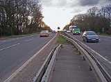
In 2006, an upgraded dual carriageway
Dual carriageway
A dual carriageway is a class of highway with two carriageways for traffic travelling in opposite directions separated by a central reservation...
section opened between Iwade
Iwade
Iwade is a small village on the north side of Detling Hill, close to the town of Sittingbourne in Kent, England. With quick access to the M2 & M20 motorways, as well as within a short driving distance to Maidstone, and further Canterbury & Faversham....
and Queenborough
Queenborough
Queenborough is a small town on the Isle of Sheppey in the Swale borough of Kent in South East England.Queenborough is two miles south of Sheerness. It grew as a port near the Thames Estuary at the westward entrance to The Swale where it joins the River Medway...
, including a new fixed crossing over the Swale
The Swale
The name The Swale refers to the strip of sea separating North Kent from the Isle of Sheppey.- History :The name "Swale" is Old English in origin, and is believed to mean "swirling, rushing river", or "rushing water"....
. The existing lifting Kingsferry Bridge
Kingsferry Bridge
The Kingsferry Bridge is a combined road and railway vertical-lift bridge connecting the Isle of Sheppey to Kent in the South East England. It was designed by Mott, Hay and Anderson, and built by John Howard, with Dorman Long and Sir William Arrol...
has been retained as an alternative route.
Route
The A249 begins close to Maidstone town centre where it commences by heading eastwards from the southbound A229A229 road
The A229 is a major road running north-south through Kent.The road begins in the Medway town of Rochester at the foot of Star Hill forming a junction with the A2 road. It then climbs up through the built-up area of Chatham, passing Troy Town and Rochester Airport before descending the slope of the...
Lower Stone Street along first Mote Road and then Wat Tyler Way
Wat Tyler
Walter "Wat" Tyler was a leader of the English Peasants' Revolt of 1381.-Early life:Knowledge of Tyler's early life is very limited, and derives mostly through the records of his enemies. Historians believe he was born in Essex, but are not sure why he crossed the Thames Estuary to Kent...
. Due to the vagaries of Maidstone's one-way system, the westbound carriageway (which was southbound before reaching Maidstone town centre), actually extends alone for a short way along Knightrider Street before it then ends as it meets the northbound carriageway of the A229. At the top of Wat Tyler Way where that road meets King Street, the A249 occupies a small gyratory system which sees the A20 reappearing heading east after a short gap due to the closure of Maidstone High Street to traffic.
From here, the A249 begins its journey north on Albion Place. This very quickly becomes the Sittingbourne
Sittingbourne
Sittingbourne is an industrial town about eight miles east of Gillingham in England, beside the Roman Watling Street off a creek in the Swale, a channel separating the Isle of Sheppey from mainland Kent...
Road, a long established route between the two old market towns. After passing Vinters Park and reaching the north end of the town at the Chiltern Hundreds roundabout (named after the adjacent pub
Public house
A public house, informally known as a pub, is a drinking establishment fundamental to the culture of Britain, Ireland, Australia and New Zealand. There are approximately 53,500 public houses in the United Kingdom. This number has been declining every year, so that nearly half of the smaller...
), this traditional route is broken as the old Sittingbourne Road has here become a Park and Ride
Park and ride
Park and ride facilities are car parks with connections to public transport that allow commuters and other people wishing to travel into city centres to leave their vehicles and transfer to a bus, rail system , or carpool for the rest of their trip...
facility.
This break occurred during the 1990s as the result of works to widen and upgrade the former A20(M) Maidstone Bypass section of the M20
M20 motorway
The M20 is a motorway in Kent, England. It runs from the M25 motorway to Folkestone, providing a link to the Channel Tunnel and the ports at Dover. It is long...
to remove a bottleneck on the newly completed motorway. Instead of following its old course, the route turns east onto the Bearsted
Bearsted
Bearsted is an ancient village and civil parish in mid-Kent, three miles to the east of Maidstone. The original village site was on the north bank of the River Len, a tributary of the River Medway, and at the foot of the North Downs....
Road towards Grove Green
Grove Green
Grove Green is a suburban housing development, partially forming a part of Weavering village, near the town of Maidstone in Kent, England. The estate is also near the village of Bearsted and is convenient for the M20 motorway making its homes keenly sought after by London commuters...
, becoming a dual carriageway before turning north again just before Newnham Court Farm. Here, the route crosses the M20, rejoining the Sittingbourne Road at the exit of the motorway roundabout. From this point onwards, the route becomes Primary.
The road now climbs up onto the Downs
North Downs
The North Downs are a ridge of chalk hills in south east England that stretch from Farnham in Surrey to the White Cliffs of Dover in Kent. The North Downs lie within two Areas of Outstanding Natural Beauty , the Surrey Hills and the Kent Downs...
via Detling Hill
Detling Hill
Detling Hill is a hill forming part of the North Downs in Kent, north-east of Maidstone, and is situated in the Kent Downs Area of Outstanding Natural Beauty. The typical southern escarpment of the North Downs is found here, and produces dramatic views over the Low Weald...
, past the village of Detling
Detling
Detling is a village and civil parish in the Borough of Maidstone in Kent, England. The parish is located on the slope of the North Downs, north east of Maidstone, and on the Pilgrims' Way....
and crossing part of the Pilgrim's Way as it does so. Just after the junction where it meets Pilgrim's Way is a footbridge called Jade's Crossing, named after the schoolgirl who died along with her grandmother in a road accident in 2000 whilst attempting to cross the busy road prior to the installation of the bridge. Immediately after the footbridge, the carriageways diverge, with the northbound carriageway taking a higher route up the hill and the southbound carriageway taking a separate lower route where it negotiates a notorious chicane
Chicane
A chicane is an artificial feature creating extra turns in a road, used in motor racing and on city streets to slow cars to lower speeds.- Motor Racing :...
at the bottom of the steep hill.
Cresting the hill, the road becomes known as the Maidstone road and passes the Kent County Showground
Kent Showground
The Kent Showground, formerly known as the Kent County Showground is an area of land in Detling, Kent, England, north of the county town of Maidstone...
to the north and White Horse Wood
White Horse Wood
White Horse Wood is a recently created English country park near Thurnham to the north of Maidstone, Kent. Located within the Kent Downs Area of Outstanding Natural Beauty, the park is a Site of Nature Conservation Interest.-Overview:...
to the south. Further on the road passes a large layby on the northbound carriageway that was closed in 2005 after local residents complained that it was a haunt of doggers
Dogging (sexual slang)
Dogging is a British English euphemism for engaging in sexual acts in a public or semi-public place or watching others doing so. There may be more than two participants; both group sex and gang banging can be included. As observation is encouraged, voyeurism and exhibitionism are closely associated...
. The road carries on past the village of Stockbury
Stockbury
Stockbury is a village near the town of Sittingbourne in Kent, England.but within the Maidstone Borough Council area.Listed in the Domesday Book.-External links:...
, uninterrupted until it meets a junction coming off the M2.
From here the route used to carry on as a single carriageway road towards Sheppey
Isle of Sheppey
The Isle of Sheppey is an island off the northern coast of Kent, England in the Thames Estuary, some to the east of London. It has an area of . The island forms part of the local government district of Swale...
on the old Maidstone Road, however a new dualled Maidstone Road running parallel but slightly west was completed in the mid nineties and this is the route that the A249 follows now under the M2 viaduct. The next junction comes at Key Street, where it meets the A2
A2 road (Great Britain)
The A2 is a major road in southern England, connecting London with the English Channel port of Dover in Kent. This route has always been of importance as a connection between the British capital of London and sea trade routes to Continental Europe...
and traffic for Newington
Newington
Newington is the name of several places, districts, a school, and a house.* England:**Greater London*** Newington, London *** Stoke Newington, a district in London*** Newington Green, a district in London**Kent*** Newington, Swale, Kent...
and Rainham to the west and Sittingbourne
Sittingbourne
Sittingbourne is an industrial town about eight miles east of Gillingham in England, beside the Roman Watling Street off a creek in the Swale, a channel separating the Isle of Sheppey from mainland Kent...
to the east join/leave.
From here the route continues across the flat plains of Swale
Swale
Swale is a local government district with borough status in Kent, England. Its council is based in Sittingbourne. The borough is named after the narrow channel called The Swale, a channel that separates the mainland of Kent from the Isle of Sheppey, and which occupies the central part of the...
past Kemsley
Kemsley
Kemsley today is a suburb of Sittingbourne in Kent, England. At the end of the 19th century it was simply a row of cottages beside a brickworks until, in 1924 when Frank Lloyd built the new Paper mill. The site was served by the creek which allowed the transport of raw materials to the site...
and Iwade
Iwade
Iwade is a small village on the north side of Detling Hill, close to the town of Sittingbourne in Kent, England. With quick access to the M2 & M20 motorways, as well as within a short driving distance to Maidstone, and further Canterbury & Faversham....
, the last villages on the mainland before the Isle of Sheppey. As it approaches Swale railway station
Swale railway station
Swale railway station is in north Kent, England, on the Sheerness Line north of Sittingbourne at the southern end of the Kingsferry Bridge which connects the Isle of Sheppey to mainland Kent. The nearest settlement is Iwade. Train services are provided by Southeastern.- History :The station was...
on the southern banks of the Swale
The Swale
The name The Swale refers to the strip of sea separating North Kent from the Isle of Sheppey.- History :The name "Swale" is Old English in origin, and is believed to mean "swirling, rushing river", or "rushing water"....
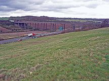
, the road becomes the Sheppey Way which now bridges the Swale via the Sheppey Crossing
Sheppey Crossing
The Sheppey Crossing is a four-lane road bridge which crosses The Swale at a height of 35m , linking the Isle of Sheppey with mainland Kent...
, opened in 2006, having previously used the Kingsferry Bridge
Kingsferry Bridge
The Kingsferry Bridge is a combined road and railway vertical-lift bridge connecting the Isle of Sheppey to Kent in the South East England. It was designed by Mott, Hay and Anderson, and built by John Howard, with Dorman Long and Sir William Arrol...
which has to be lifted to allow ships to pass on the Swale. Non-motorised traffic still uses the old route and rejoins the A249 on the island.
Once on the island, traffic follows a new dual carriageway built in conjunction with the new bridge as far as Queenborough
Queenborough
Queenborough is a small town on the Isle of Sheppey in the Swale borough of Kent in South East England.Queenborough is two miles south of Sheerness. It grew as a port near the Thames Estuary at the westward entrance to The Swale where it joins the River Medway...
. Here it returns to its old single carriageway route along Brielle way into Sheerness, past Blue Town
Blue Town
Blue Town is a suburb of the town of Sheerness on the Isle of Sheppey in Kent. It sits on the A249 Brielle Way which runs from Queenborough to Sheerness....
before finally turning into Bridge Road and ending at a roundabout near the seaport. Here the road becomes the A250
A250 road (Great Britain)
The A250 road is a minor British A-road on the Isle of Sheppey in Kent. The route runs from Sheerness to Queenborough via Halfway.-Route:The A250 begins in Queenborough where it splits off from the A249, with the formerly northbound A249 turning northwest towards Blue Town and the A250 heading...
.
Junctions
| A249 Road | ||
| Northbound exits | Junction | Southbound exits |
| Sheerness-on-Sea railway station Sheerness-on-Sea railway station Sheerness-on-Sea railway station is on the Sheerness Line in north Kent, and serves the town of Sheerness. Train services are provided by Southeastern.The only platform now used is platform 1.-History:... , Sheerness Docks A250 Start/End of Road |
||
| Local access | ||
| Blue Town Blue Town Blue Town is a suburb of the town of Sheerness on the Isle of Sheppey in Kent. It sits on the A249 Brielle Way which runs from Queenborough to Sheerness.... |
||
| No exit | ||
| Queenborough Queenborough Queenborough is a small town on the Isle of Sheppey in the Swale borough of Kent in South East England.Queenborough is two miles south of Sheerness. It grew as a port near the Thames Estuary at the westward entrance to The Swale where it joins the River Medway... B2007 |
||
| End of Dual Carriageway | Start of Dual Carriageway | |
| Queenborough B2007 | Queenborough B2007 Minster-on-Sea A250 |
|
| Minster-on-Sea A250 | No exit | |
| Eastchurch Eastchurch Eastchurch is a village on the Isle of Sheppey, in the English county of Kent, two miles east of Minster.The village website claims "... it has a history steeped in stories of piracy and smugglers".- Aviation history :... B2007 |
Eastchurch B2007 | |
| The Sheppey Crossing | ||
| Iwade Iwade Iwade is a small village on the north side of Detling Hill, close to the town of Sittingbourne in Kent, England. With quick access to the M2 & M20 motorways, as well as within a short driving distance to Maidstone, and further Canterbury & Faversham.... , Kingsferry Bridge Kingsferry Bridge The Kingsferry Bridge is a combined road and railway vertical-lift bridge connecting the Isle of Sheppey to Kent in the South East England. It was designed by Mott, Hay and Anderson, and built by John Howard, with Dorman Long and Sir William Arrol... |
No exit | |
| Kemsley Kemsley Kemsley today is a suburb of Sittingbourne in Kent, England. At the end of the 19th century it was simply a row of cottages beside a brickworks until, in 1924 when Frank Lloyd built the new Paper mill. The site was served by the creek which allowed the transport of raw materials to the site... B2005 Iwade |
Kemsley B2005 Iwade |
|
| Kemsley B2005 | Sittingbourne Sittingbourne Sittingbourne is an industrial town about eight miles east of Gillingham in England, beside the Roman Watling Street off a creek in the Swale, a channel separating the Isle of Sheppey from mainland Kent... , Kemsley B2005 |
|
| Rainham, Sittingbourne Sittingbourne Sittingbourne is an industrial town about eight miles east of Gillingham in England, beside the Roman Watling Street off a creek in the Swale, a channel separating the Isle of Sheppey from mainland Kent... A2 A2 road (Great Britain) The A2 is a major road in southern England, connecting London with the English Channel port of Dover in Kent. This route has always been of importance as a connection between the British capital of London and sea trade routes to Continental Europe... |
No exit | |
| London London London is the capital city of :England and the :United Kingdom, the largest metropolitan area in the United Kingdom, and the largest urban zone in the European Union by most measures. Located on the River Thames, London has been a major settlement for two millennia, its history going back to its... , Dover Dover Dover is a town and major ferry port in the home county of Kent, in South East England. It faces France across the narrowest part of the English Channel, and lies south-east of Canterbury; east of Kent's administrative capital Maidstone; and north-east along the coastline from Dungeness and Hastings... , Gillingham, Canterbury Canterbury Canterbury is a historic English cathedral city, which lies at the heart of the City of Canterbury, a district of Kent in South East England. It lies on the River Stour.... M2 Danaway Danaway Danaway is a village near the A249 road and the M2 motorway, in the Swale District, in the English county of Kent. The nearest town is Sittingbourne.- References :A-Z Great Britain Road Atlas... |
M2 J5 | London, Dover, Gillingham, Canterbury M2 Danaway |
| Oad Street Oad Street Oad Street is a small village in the English county of Kent.Oad Street forms part of the civil parish of Borden which, in turn, is part of Swale district. Oad Street is located close to Junction 5 of the M2 motorway where it crosses the A249 road.... |
Oad Street | |
| Stockbury Stockbury Stockbury is a village near the town of Sittingbourne in Kent, England.but within the Maidstone Borough Council area.Listed in the Domesday Book.-External links:... |
Stockbury | |
| Stockbury | Stockbury | |
| Local road | Local road | |
| Local road | Local road | |
| Kent County Showground Kent Showground The Kent Showground, formerly known as the Kent County Showground is an area of land in Detling, Kent, England, north of the county town of Maidstone... |
Kent County Showground | |
| Detling Detling Detling is a village and civil parish in the Borough of Maidstone in Kent, England. The parish is located on the slope of the North Downs, north east of Maidstone, and on the Pilgrims' Way.... |
Detling | |
| Ashford Ashford, Kent Ashford is a town in the borough of Ashford in Kent, England. In 2005 it was voted the fourth best place to live in the United Kingdom. It lies on the Great Stour river, the M20 motorway, and the South Eastern Main Line and High Speed 1 railways. Its agricultural market is one of the most... , Folkestone Folkestone Folkestone is the principal town in the Shepway District of Kent, England. Its original site was in a valley in the sea cliffs and it developed through fishing and its closeness to the Continent as a landing place and trading port. The coming of the railways, the building of a ferry port, and its... , Channel Tunnel Channel Tunnel The Channel Tunnel is a undersea rail tunnel linking Folkestone, Kent in the United Kingdom with Coquelles, Pas-de-Calais near Calais in northern France beneath the English Channel at the Strait of Dover. At its lowest point, it is deep... , London London London is the capital city of :England and the :United Kingdom, the largest metropolitan area in the United Kingdom, and the largest urban zone in the European Union by most measures. Located on the River Thames, London has been a major settlement for two millennia, its history going back to its... , Gatwick Airport (M25 M25 motorway The M25 motorway, or London Orbital, is a orbital motorway that almost encircles Greater London, England, in the United Kingdom. The motorway was first mooted early in the 20th century. A few sections, based on the now abandoned London Ringways plan, were constructed in the early 1970s and it ... , M26 M26 motorway The M26 is a motorway in Kent, England. It provides a short link between the M25/A21 at Sevenoaks and the M20 near Wrotham.-Route:The motorway starts at junction 3 of the M20 and heads west, encountering almost immediately the single junction along its length where it has an interchange with the A20... ) M20 M20 motorway The M20 is a motorway in Kent, England. It runs from the M25 motorway to Folkestone, providing a link to the Channel Tunnel and the ports at Dover. It is long... |
Ashford, Folkestone, Channel Tunnel, London, Gatwick Airport (M25, M26) M20 |
|
| Grove Green Grove Green Grove Green is a suburban housing development, partially forming a part of Weavering village, near the town of Maidstone in Kent, England. The estate is also near the village of Bearsted and is convenient for the M20 motorway making its homes keenly sought after by London commuters... |
Grove Green | |
| Penenden Heath Penenden Heath Penenden Heath is a suburb in the town of Maidstone in Kent, England.As the name suggests it is nucleated around a former heath .-History:... , Park and Ride Park and ride Park and ride facilities are car parks with connections to public transport that allow commuters and other people wishing to travel into city centres to leave their vehicles and transfer to a bus, rail system , or carpool for the rest of their trip... Start of Dual Carriageway |
Penenden Heath, Park and Ride End of Dual Carriageway |
|
| Ashford A20 | ||
| Ashford, Maidstone A20 Start/End of Road |
||