
2009 Alaska floods
Encyclopedia
The 2009 Alaska floods were a series of natural disasters taking place in the United States state of Alaska
during April and May 2009. The floods are a result of heavier-than-typical winter snowfall and above-average spring temperatures that resulted in rapid melting of the winter snowfall. The resulting high water levels were aggravated in places by the development of ice dam
s that caused catastrophic flooding. The record-breaking flood that affected Eagle, Alaska
in early May is the best example of an ice dam causing flooding beyond the norm.
, on the Bering Sea
coast, received a record 102 inches of snowfall—more than double the average of about 40 inches. In other locations, winter snowfall did not set records but still was heavier than average. Fairbanks
, Alaska's second-largest city, received 71.5 inches of snow and was covered by unusually cold temperatures for the first three months of the year, preventing early melting of the snowpack. Snow also fell heavily in Lake Minchumina
and the Alaska Range
. At Eagle, the ice on the Yukon River was 55 inches thick—more than 40 percent greater than normal.
By mid-April, concerns were raised that the heavy snowpack could pose problems if it melted quickly. "There’s plenty of snowpack out there to cause problems this year," warned a National Weather Service
meteorologist at the time.
In Fairbanks and most of Interior Alaska, temperatures remained below freezing for most of April and temperatures did not hit 50 degrees until April 26. After that date, temperatures rose rapidly. By April 28, the snowpack at Fairbanks International Airport had melted, leaving only snow berms and piles. The next day, Fairbanks recorded a record high temperature of 74 degrees. On April 30, Fairbanks set an all-time high temperature for the month of April when the thermometer reached 76 degrees. Record high temperatures also were recorded at Eagle, Delta Junction
, and other towns in central Alaska. In less than one week, central Alaska residents went from skiing to swatting mosquito
es. The warmup was so rapid that on May 1, the Alaska Division of Forestry issued its first wildfire
alert of the year. By that date, however, rivers across central Alaska already were flooding.
was the first area of Alaska to feel the effects of spring flooding. On April 28, the ice on the Salcha River
broke up, flowed into the Tanana River, and formed an ice jam. The jam partially dammed the river, flooding low-lying areas of the town of Salcha
. High temperatures during the following couple of days added to the ice jam, and several families were forced from their homes by the rising water. Fairbanks North Star Borough officials set up a self-serve sand bag station at the Salcha Fairgrounds, and residents near the river erected impromptu levee
s. The Salcha ice jam broke loose on April 30, causing flood levels to decline dramatically. Record-high temperatures that day caused jams to form on other rivers in the area, however.
On the Chatanika River
, a jam caused a flood that threatened several homes before the ice broke loose and caused water levels to drop. By May 1, almost the entire Fairbanks North Star Borough was directly threatened by some sort of flooding. In Fox
, small-stream flooding caused a house to be evacuated. Flooding was reported in North Pole
and in rural areas of the borough. On May 2, high water on the Chena River swept through Fairbanks, causing flooding in low-lying areas. The high water caused the U.S. Army Corps of Engineers to consider closing the floodgates at the Chena River Lakes Flood Control Project, a structure built to protect Fairbanks from flooding. The high water registered just below the threshold to close the gates, however, and they remained open throughout the flood. By May 5, the water receded in Fairbanks and the surrounding area as the Tanana River drained floodwater into the Yukon. The draining high water ripped a barge away from its moorings in the Tanana River near Nenana
, causing it to float down the Yukon River until it was arrested by a helicopter.
near the villages of Upper
and Lower Kalskag
. These jams caused the snowmelt-bolstered river to flood areas around both villages, forcing residents to take action. After the jams broke and flowed downriver, they re-formed near Akiak
. The resulting flood caused the evacuation of more than 10 percent of the town's residents to nearby Bethel, while many of the remaining residents sought shelter in the local school.
and smashed into stores and buildings. The Alaska Native settlement of Eagle Village
was severely flooded and virtually destroyed by marauding blocks of ice. In Eagle itself, floodwater lifted buildings off their foundations and caused havoc for the town's 120-plus residents.
The river surge hit Fort Yukon
on May 7 and early in the morning of May 8. Although the flood reached 4 feet (1.2 m) above flood stage, it did not top the town's Yukon River levee. Areas outside the levee received minor flooding, and some residents were evacuated to the village school and to Fort Yukon Air Force Station.
, Holy Cross
, and Nulato
by May 16.
On May 3, National Park Service employees from the headquarters of the Yukon-Charley Rivers National Preserve in Eagle moved to support residents of the town who had been flooded out of their homes. Supplies of food and water were delivered to old Eagle Village on May 5, and the next day, officials from the Alaska Division of Homeland Security and Emergency Management arrived to manage the response from a headquarters set up at Eagle's school. By Thursday, May 7, National Park Service helicopters were airborne, checking on people in isolated homesteads near and within the preserve.
On May 6, Governor
Sarah Palin
declared the drainages of the Yukon, Kuskokwim, Kobuk, and Susitna rivers to be disaster areas. The next day, she canceled a trip to attend the White House Correspondents Dinner in order to survey the damaged communities.
In Fairbanks, private citizens donated more than 7000 pounds (3,175 kg) of supplies to Eagle residents. The amount of donations was so great that the airline that volunteered to fly the supplies to Eagle was overwhelmed. By May 7, the total amount of private donations exceeded 10500 pounds (4,763 kg).
By May 10, larger amounts of government aid began reaching affected areas. Akiak on the Kuskokwim River received diesel fuel, potable water, food, and other items, while four 400-gallon (1,514-liter) water tanks were sent to Eagle to alleviate problems caused by contaminated wells.
Alaska
Alaska is the largest state in the United States by area. It is situated in the northwest extremity of the North American continent, with Canada to the east, the Arctic Ocean to the north, and the Pacific Ocean to the west and south, with Russia further west across the Bering Strait...
during April and May 2009. The floods are a result of heavier-than-typical winter snowfall and above-average spring temperatures that resulted in rapid melting of the winter snowfall. The resulting high water levels were aggravated in places by the development of ice dam
Ice dam
An ice dam occurs when water builds up behind a blockage of ice. Ice dams can occur in various ways.-Caused by a glacier:Sometimes a glacier flows down a valley to a confluence where the other branch carries an unfrozen river...
s that caused catastrophic flooding. The record-breaking flood that affected Eagle, Alaska
Eagle, Alaska
Eagle is a city located along the United States-Canada border in the Southeast Fairbanks Census Area, Alaska, United States. It includes Eagle Historic District, a U.S. National Historic Landmark. The population was 129 at the 2000 census...
in early May is the best example of an ice dam causing flooding beyond the norm.
Causes
The winter of 2008–2009 brought unusually heavy snowfall to much of Alaska. KotzebueKotzebue, Alaska
As of the census of 2000, there were 3,082 people, 889 households, and 656 families residing in the city. The population density was 114.1 people per square mile . There were 1,007 housing units at an average density of 37.3 per square mile...
, on the Bering Sea
Bering Sea
The Bering Sea is a marginal sea of the Pacific Ocean. It comprises a deep water basin, which then rises through a narrow slope into the shallower water above the continental shelves....
coast, received a record 102 inches of snowfall—more than double the average of about 40 inches. In other locations, winter snowfall did not set records but still was heavier than average. Fairbanks
Fairbanks, Alaska
Fairbanks is a home rule city in and the borough seat of the Fairbanks North Star Borough in the U.S. state of Alaska.Fairbanks is the largest city in the Interior region of Alaska, and second largest in the state behind Anchorage...
, Alaska's second-largest city, received 71.5 inches of snow and was covered by unusually cold temperatures for the first three months of the year, preventing early melting of the snowpack. Snow also fell heavily in Lake Minchumina
Lake Minchumina, Alaska
Lake Minchumina is a census-designated place in Yukon-Koyukuk Census Area, Alaska, United States. As of the 2000 census, the population of the CDP is 32.-Geography:Lake Minchumina is located at ....
and the Alaska Range
Alaska Range
The Alaska Range is a relatively narrow, 650-km-long mountain range in the southcentral region of the U.S. state of Alaska, from Lake Clark at its southwest end to the White River in Canada's Yukon Territory in the southeast...
. At Eagle, the ice on the Yukon River was 55 inches thick—more than 40 percent greater than normal.
By mid-April, concerns were raised that the heavy snowpack could pose problems if it melted quickly. "There’s plenty of snowpack out there to cause problems this year," warned a National Weather Service
National Weather Service
The National Weather Service , once known as the Weather Bureau, is one of the six scientific agencies that make up the National Oceanic and Atmospheric Administration of the United States government...
meteorologist at the time.
In Fairbanks and most of Interior Alaska, temperatures remained below freezing for most of April and temperatures did not hit 50 degrees until April 26. After that date, temperatures rose rapidly. By April 28, the snowpack at Fairbanks International Airport had melted, leaving only snow berms and piles. The next day, Fairbanks recorded a record high temperature of 74 degrees. On April 30, Fairbanks set an all-time high temperature for the month of April when the thermometer reached 76 degrees. Record high temperatures also were recorded at Eagle, Delta Junction
Delta Junction, Alaska
Delta Junction is a city in the Southeast Fairbanks Census Area, Alaska, United States. According to 2005 Census Bureau estimates, the population of the city is 897. The city is located a short distance south of the confluence of the Delta River with the Tanana River, which is at Big Delta...
, and other towns in central Alaska. In less than one week, central Alaska residents went from skiing to swatting mosquito
Mosquito
Mosquitoes are members of a family of nematocerid flies: the Culicidae . The word Mosquito is from the Spanish and Portuguese for little fly...
es. The warmup was so rapid that on May 1, the Alaska Division of Forestry issued its first wildfire
Wildfire
A wildfire is any uncontrolled fire in combustible vegetation that occurs in the countryside or a wilderness area. Other names such as brush fire, bushfire, forest fire, desert fire, grass fire, hill fire, squirrel fire, vegetation fire, veldfire, and wilkjjofire may be used to describe the same...
alert of the year. By that date, however, rivers across central Alaska already were flooding.
Tanana Valley
The Tanana River valleyTanana Valley
The Tanana Valley is a lowland region in central Alaska in the United States, on the north side of the Alaska Range where the Tanana River emerges from the mountains.-Climate:...
was the first area of Alaska to feel the effects of spring flooding. On April 28, the ice on the Salcha River
Salcha River
The Salcha River is a river in Alaska in the United States located southeast and east of Fairbanks, in the eastern portion of Fairbanks North Star Borough. It is long and drains an area of some , making it the second largest tributary of the Tanana River, joining it at Aurora Lodge...
broke up, flowed into the Tanana River, and formed an ice jam. The jam partially dammed the river, flooding low-lying areas of the town of Salcha
Salcha, Alaska
Salcha is a census-designated place in Fairbanks North Star Borough in the U.S. state of Alaska. It is part of the 'Fairbanks, Alaska Metropolitan Statistical Area'. The population was 854 at the 2000 census.-Geography:...
. High temperatures during the following couple of days added to the ice jam, and several families were forced from their homes by the rising water. Fairbanks North Star Borough officials set up a self-serve sand bag station at the Salcha Fairgrounds, and residents near the river erected impromptu levee
Levee
A levee, levée, dike , embankment, floodbank or stopbank is an elongated naturally occurring ridge or artificially constructed fill or wall, which regulates water levels...
s. The Salcha ice jam broke loose on April 30, causing flood levels to decline dramatically. Record-high temperatures that day caused jams to form on other rivers in the area, however.
On the Chatanika River
Chatanika River
The Chatanika River is a river in the U.S. state of Alaska. The Chatanika River is a clear or lightly tannic stained rapid-runoff stream that has its headwaters in the mountains of the northeastern portion of the Alaska Range and flows westward through valleys between summits and uplands for about...
, a jam caused a flood that threatened several homes before the ice broke loose and caused water levels to drop. By May 1, almost the entire Fairbanks North Star Borough was directly threatened by some sort of flooding. In Fox
Fox, Alaska
Fox is a census-designated place in Fairbanks North Star Borough, Alaska, United States. It is part of the Fairbanks, Alaska Metropolitan Statistical Area. At the 2007 census the population was 353.-Geography:...
, small-stream flooding caused a house to be evacuated. Flooding was reported in North Pole
North Pole, Alaska
North Pole is a small city in the Fairbanks North Star Borough, Alaska, United States. It is part of the Fairbanks, Alaska metropolitan statistical area. The U.S. Census Bureau estimated its population as of July 1, 2009 at 2,226. The name "North Pole" is often applied to the entire area covered...
and in rural areas of the borough. On May 2, high water on the Chena River swept through Fairbanks, causing flooding in low-lying areas. The high water caused the U.S. Army Corps of Engineers to consider closing the floodgates at the Chena River Lakes Flood Control Project, a structure built to protect Fairbanks from flooding. The high water registered just below the threshold to close the gates, however, and they remained open throughout the flood. By May 5, the water receded in Fairbanks and the surrounding area as the Tanana River drained floodwater into the Yukon. The draining high water ripped a barge away from its moorings in the Tanana River near Nenana
Nenana, Alaska
Nenana is a Home Rule City in the Yukon-Koyukuk Census Area of the Unorganized Borough of the U.S. state of Alaska. Nenana lies at the juncture of the Nenana River and the Tanana River. The population was 402 at the 2000 census. "Nenana" means 'a good place to camp between two rivers.'-History...
, causing it to float down the Yukon River until it was arrested by a helicopter.
Kuskokwim River
On May 6, multiple ice jams formed on the Kuskokwim RiverKuskokwim River
The Kuskokwim River or Kusko River is a river, long, in Southwest Alaska in the United States. It is the ninth largest river in the United States by average discharge volume at its mouth and seventeenth largest by basin drainage area.The river provides the principal drainage for an area of the...
near the villages of Upper
Upper Kalskag, Alaska
Upper Kalskag is a city in Bethel Census Area, Alaska, United States. At the 2000 census the population was 230.-Geography:Upper Kalskag is located at ....
and Lower Kalskag
Lower Kalskag, Alaska
Lower Kalskag is a city in Bethel Census Area, Alaska, United States. At the 2000 census the population was 267.-Geography:Lower Kalskag is located at ....
. These jams caused the snowmelt-bolstered river to flood areas around both villages, forcing residents to take action. After the jams broke and flowed downriver, they re-formed near Akiak
Akiak, Alaska
Akiak is a city in Bethel Census Area, Alaska, United States. The population was 309 at the 2000 census....
. The resulting flood caused the evacuation of more than 10 percent of the town's residents to nearby Bethel, while many of the remaining residents sought shelter in the local school.
Susitna River
On May 3, an ice jam formed on the Susitna River, causing flooding that washed out the tracks of the Alaska Railroad. Large chunks of ice also were pushed onto the tracks, making work difficult for crews assigned to repair the rail line. The incident severed rail traffic between Fairbanks and Anchorage until May 7, when track repairs were completed and the railroad resumed service.Eagle and Eagle Village
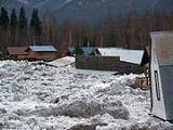
On May 3 and May 4, ice on the Yukon River near the Alaska/Canada border began to break up. Open water was seen near the town of Eagle, which is just west of the border. On May 4, a large ice jam developed about 10 miles downriver of Eagle. The high-flowing Yukon, fueled by snowmelt from the high temperatures of the previous week, soon flooded the town. Large chunks of ice were carried over the town's riverbank retaining wallRetaining wall
Retaining walls are built in order to hold back earth which would otherwise move downwards. Their purpose is to stabilize slopes and provide useful areas at different elevations, e.g...
and smashed into stores and buildings. The Alaska Native settlement of Eagle Village
Eagle Village, Alaska
Eagle Village is a census-designated place in Southeast Fairbanks Census Area, Alaska, United States. The population was 68 at the 2000 census....
was severely flooded and virtually destroyed by marauding blocks of ice. In Eagle itself, floodwater lifted buildings off their foundations and caused havoc for the town's 120-plus residents.
Middle Yukon
The high water released by the Eagle ice jam reached Circle, the next significant town downriver from Eagle, on May X.The river surge hit Fort Yukon
Fort Yukon, Alaska
As of the census of 2000, there were 595 people, 225 households, and 137 families residing in the city. The population density was 85.0 people per square mile . There were 317 housing units at an average density of 45.3 per square mile...
on May 7 and early in the morning of May 8. Although the flood reached 4 feet (1.2 m) above flood stage, it did not top the town's Yukon River levee. Areas outside the levee received minor flooding, and some residents were evacuated to the village school and to Fort Yukon Air Force Station.
Lower Yukon
The surge of water released from the Yukon River near Eagle in the first week of May reached the lower Yukon villages of GraylingGrayling, Alaska
Grayling is a city in Yukon-Koyukuk Census Area, Alaska, United States. At the 2000 census the population was 194. Since 1977, the Athabaskan village has seen a surge of interest on odd-numbered years, when it is the site of a checkpoint during the Iditarod Trail Sled Dog Race...
, Holy Cross
Holy Cross, Alaska
Holy Cross is a city in Yukon-Koyukuk Census Area, Alaska, United States...
, and Nulato
Nulato, Alaska
Nulato is a city in Yukon-Koyukuk Census Area, Alaska, United States. At the 2000 census the population was 336.-Geography:Nulato is located at ....
by May 16.
Response
Initial responses to the flooding were organized by people and organizations closest to the separate disasters. Most efforts were focused on assisting residents of Eagle, but notable help was given to other affected communities, including Akiak and Stevens Village.On May 3, National Park Service employees from the headquarters of the Yukon-Charley Rivers National Preserve in Eagle moved to support residents of the town who had been flooded out of their homes. Supplies of food and water were delivered to old Eagle Village on May 5, and the next day, officials from the Alaska Division of Homeland Security and Emergency Management arrived to manage the response from a headquarters set up at Eagle's school. By Thursday, May 7, National Park Service helicopters were airborne, checking on people in isolated homesteads near and within the preserve.
On May 6, Governor
Governor
A governor is a governing official, usually the executive of a non-sovereign level of government, ranking under the head of state...
Sarah Palin
Sarah Palin
Sarah Louise Palin is an American politician, commentator and author. As the Republican Party nominee for Vice President in the 2008 presidential election, she was the first Alaskan on the national ticket of a major party and first Republican woman nominated for the vice-presidency.She was...
declared the drainages of the Yukon, Kuskokwim, Kobuk, and Susitna rivers to be disaster areas. The next day, she canceled a trip to attend the White House Correspondents Dinner in order to survey the damaged communities.
In Fairbanks, private citizens donated more than 7000 pounds (3,175 kg) of supplies to Eagle residents. The amount of donations was so great that the airline that volunteered to fly the supplies to Eagle was overwhelmed. By May 7, the total amount of private donations exceeded 10500 pounds (4,763 kg).
By May 10, larger amounts of government aid began reaching affected areas. Akiak on the Kuskokwim River received diesel fuel, potable water, food, and other items, while four 400-gallon (1,514-liter) water tanks were sent to Eagle to alleviate problems caused by contaminated wells.