

2008 Benin floods
Encyclopedia
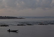
The 2008 Benin floods struck the nation of Benin
between July and October 2008, and affected the other West African nations of Burkina Faso
, Mali
, Mauritania
, Niger
and Togo
. According to the Red Cross of Benin, the flooding in Benin initially affected almost 7,000 people, including the displacement of 1,560 children. and by August 19, 2008, the World Health Organization
(WHO) estimated that the flooding had displaced at least 150,000 people. Some 500,000 people in total were at risk of additional flooding.
, Ouinhi
and Za-Kpota
, tearing down mud and straw homes and infrastructure and polluting rivers. The Mono River
and Ouémé River
which flows down through central Benin into the economic capital of Cotonou
on the coast in particular was a problem. Weeks after the initial flooding in July 2008, many areas of Cotonou were still not drained, posing a serious risk to health given that the flooding affected many densely populated areas and some 10% of the nation's population live in the city. Representatives from the municipal council of Cotonou, WHO’s Cotonou office and the Benin’s Ministry of Hygiene, Public Health and Social Affairs, urged on 15 August 2008 that an evacuation and relocation plan was required given that heavier storms were expected in September and October.
On September 15, 2008 reports broke out that the commune of Adjohoun
had been seriously affected by the flooding of the Ouémé River
. The area, which is a fertile agricultural valley, threatened the livelihoods of some 57,000 people. The flooding had begun as in other places in late July but storms in early September struck the region worse. More than 25,000 hectares of crop land was inundated, killing some 30,000 animals and flooding 18,000 homes in the commune. Approximately 2,000 people were displaced in the communities of Azowlissé
, Dèmè
, Gangban
, Kogé
and Togbota
with the exception of Awonou
, located further away from the river. According to one council official, while Benin often experiences flooding, notably in 1995 and 2007, the floods of 2008 were particularly devastating on the livelihoods of the Beninois people, "People cannot even eat three times a day now. Even to find food once a day is a headache. Normally, agricultural products are bought and sold here at decent prices. But now things have changed." The regional mayor of Adjohoun, Gerard Adounsiba, requested a national funding appeal to provide food and medical in what was according to him, "the largest humanitarian crisis in the region to date." The situation was made worse by the fact that the hospitals in the area were affected by flooding. Livelihoods of local fisherman which depend upon the river were also severely affected.
in Cotonou and helped fund US$20,000 towards the government’s cholera treatment efforts. According to Dr. Eric Laroche, Assistant Director-General of WHO , "West Africa's annual floods bring with them not only the threat of vector-borne and communicable diseases, but it further endangers the lives of people already malnourished by the food price crisis." The flooding increased the risk of Meningitis
and yellow fever
as well as posing a threat to an estimated 5 million people living with HIV/AIDS in West Africa. Malaria
, diarrhoeal and respiratory infections, and malnutrition
posed a threat to the population living along the river basins.
Benin
Benin , officially the Republic of Benin, is a country in West Africa. It borders Togo to the west, Nigeria to the east and Burkina Faso and Niger to the north. Its small southern coastline on the Bight of Benin is where a majority of the population is located...
between July and October 2008, and affected the other West African nations of Burkina Faso
Burkina Faso
Burkina Faso – also known by its short-form name Burkina – is a landlocked country in west Africa. It is surrounded by six countries: Mali to the north, Niger to the east, Benin to the southeast, Togo and Ghana to the south, and Côte d'Ivoire to the southwest.Its size is with an estimated...
, Mali
Mali
Mali , officially the Republic of Mali , is a landlocked country in Western Africa. Mali borders Algeria on the north, Niger on the east, Burkina Faso and the Côte d'Ivoire on the south, Guinea on the south-west, and Senegal and Mauritania on the west. Its size is just over 1,240,000 km² with...
, Mauritania
Mauritania
Mauritania is a country in the Maghreb and West Africa. It is bordered by the Atlantic Ocean in the west, by Western Sahara in the north, by Algeria in the northeast, by Mali in the east and southeast, and by Senegal in the southwest...
, Niger
Niger
Niger , officially named the Republic of Niger, is a landlocked country in Western Africa, named after the Niger River. It borders Nigeria and Benin to the south, Burkina Faso and Mali to the west, Algeria and Libya to the north and Chad to the east...
and Togo
Togo
Togo, officially the Togolese Republic , is a country in West Africa bordered by Ghana to the west, Benin to the east and Burkina Faso to the north. It extends south to the Gulf of Guinea, on which the capital Lomé is located. Togo covers an area of approximately with a population of approximately...
. According to the Red Cross of Benin, the flooding in Benin initially affected almost 7,000 people, including the displacement of 1,560 children. and by August 19, 2008, the World Health Organization
World Health Organization
The World Health Organization is a specialized agency of the United Nations that acts as a coordinating authority on international public health. Established on 7 April 1948, with headquarters in Geneva, Switzerland, the agency inherited the mandate and resources of its predecessor, the Health...
(WHO) estimated that the flooding had displaced at least 150,000 people. Some 500,000 people in total were at risk of additional flooding.
Flooding
The floods begin in the last week of July 2008 with a series of storms which affected central Benin in the communities of Sagon, Tohoue, DassoDasso
-People with the surname Dasso:*Andrés F. Dasso , Peruvian politician, mayor of Lima 1922–25*Frank Dasso , American professional baseball player*Willy Dasso , Peruvian Olympic basketball player...
, Ouinhi
Ouinhi
Ouinhi is a town, arrondissement, and commune in the Zou Department of south-western Benin. The commune covers an area of 483 square kilometres and as of 2002 had a population of 38,319 people....
and Za-Kpota
Za-Kpota
Za-Kpota or Zakpota is a town, arrondissement, and commune in the Zou Department of south-western Benin. It is located 153 kilometres north of Cotonou and 33 kilometres east of Abomey .-History:...
, tearing down mud and straw homes and infrastructure and polluting rivers. The Mono River
Mono River
The Mono River is the major river of eastern Togo.Approximately long, and draining a basin of about , it rises between the town of Sokodé and the border with Benin, and flows south. Along the southern portion of the river towards its mouth, it forms the international boundary between Togo and Benin...
and Ouémé River
Ouémé River
The Ouémé River is a river in the countries of Benin and Nigeria. It flows into the Atlantic Ocean near the large city of Cotonou, Benin .Also known as the Weme River, this river has its source in the Atakora Mountains of Benin...
which flows down through central Benin into the economic capital of Cotonou
Cotonou
-Demographics:*1979: 320,348 *1992: 536,827 *2002: 665,100 *2005: 690,584 The main languages spoken in Cotonou include the Fon language, Aja language, Yoruba language and French.-Transport:...
on the coast in particular was a problem. Weeks after the initial flooding in July 2008, many areas of Cotonou were still not drained, posing a serious risk to health given that the flooding affected many densely populated areas and some 10% of the nation's population live in the city. Representatives from the municipal council of Cotonou, WHO’s Cotonou office and the Benin’s Ministry of Hygiene, Public Health and Social Affairs, urged on 15 August 2008 that an evacuation and relocation plan was required given that heavier storms were expected in September and October.
On September 15, 2008 reports broke out that the commune of Adjohoun
Adjohoun
Adjohoun or Adjohon is a town, arrondissement, and commune in Ouémé Department, Benin. The commune is divided into 8 arrondisements and 57 villages.The commune of Adjohoun is located approximately 32 km from Porto-Novo and 62 km from Cotonou...
had been seriously affected by the flooding of the Ouémé River
Ouémé River
The Ouémé River is a river in the countries of Benin and Nigeria. It flows into the Atlantic Ocean near the large city of Cotonou, Benin .Also known as the Weme River, this river has its source in the Atakora Mountains of Benin...
. The area, which is a fertile agricultural valley, threatened the livelihoods of some 57,000 people. The flooding had begun as in other places in late July but storms in early September struck the region worse. More than 25,000 hectares of crop land was inundated, killing some 30,000 animals and flooding 18,000 homes in the commune. Approximately 2,000 people were displaced in the communities of Azowlissé
Azowlissé
Azowlissé is a small town and arrondissement located in the commune of Adjohoun in the Borgou Department of Benin. Agriculture is the main industry lying in the fertile Ouémé River Valley of southern Benin. In 2008 during the 2008 Benin floods, the area was affected by the flooding of the Ouémé...
, Dèmè
Dèmè
Dèmè is a small town and arrondissement located in the commune of Adjohoun in the Borgou Department of Benin. Agriculture is the main industry lying in the fertile Ouémé River Valley of southern Benin. In 2008 during the 2008 Benin floods, the area was affected by the flooding of the Ouémé River...
, Gangban
Gangban
Gangban is a small town and the seat of the Tohouè arrondissement located in the commune of Ouinhi in the Zou Department of Benin. Agriculture is the main industry lying in the fertile Ouémé River Valley of southern Benin.-2008 flooding:...
, Kogé
Kogé
Kogé is a small town and arrondissement located in the commune of Adjohoun in the Borgou Department of Benin. Agriculture is the main industry lying in the fertile Ouémé River Valley of southern Benin. In 2008 during the 2008 Benin floods, the area was affected by the flooding of the Ouémé River...
and Togbota
Togbota
Togbota is a small town and arrondissement located in the commune of Adjohoun in the Borgou Department of Benin. Agriculture is the main industry lying in the fertile Ouémé River Valley of southern Benin. In 2008 during the 2008 Benin floods, the area was affected by the flooding of the Ouémé River...
with the exception of Awonou
Awonou
Awonou is a small town and arrondissement located in the commune of Adjohoun in the Borgou Department of Benin. Agriculture is the main industry. In 2008 during the 2008 Benin floods, Awonou was the only area not affected by the flooding of the Ouémé River which affected much of Adjohoun commune....
, located further away from the river. According to one council official, while Benin often experiences flooding, notably in 1995 and 2007, the floods of 2008 were particularly devastating on the livelihoods of the Beninois people, "People cannot even eat three times a day now. Even to find food once a day is a headache. Normally, agricultural products are bought and sold here at decent prices. But now things have changed." The regional mayor of Adjohoun, Gerard Adounsiba, requested a national funding appeal to provide food and medical in what was according to him, "the largest humanitarian crisis in the region to date." The situation was made worse by the fact that the hospitals in the area were affected by flooding. Livelihoods of local fisherman which depend upon the river were also severely affected.
Response
Part of the problem with the flooding was that few who succumbed to the flooding were unwilling to evacuate their homes in Cotonou. The district of Vossa was completely inundated in flood water and a disaster relief team from WHO had to be sent in to Ayelawadje district of the city whilst UN agencies collaborated with the Cotonou government to pump out water and clear roads in the capital. Since July 30, 2008, the World Health Organization reported 192 cases of choleraCholera
Cholera is an infection of the small intestine that is caused by the bacterium Vibrio cholerae. The main symptoms are profuse watery diarrhea and vomiting. Transmission occurs primarily by drinking or eating water or food that has been contaminated by the diarrhea of an infected person or the feces...
in Cotonou and helped fund US$20,000 towards the government’s cholera treatment efforts. According to Dr. Eric Laroche, Assistant Director-General of WHO , "West Africa's annual floods bring with them not only the threat of vector-borne and communicable diseases, but it further endangers the lives of people already malnourished by the food price crisis." The flooding increased the risk of Meningitis
Meningitis
Meningitis is inflammation of the protective membranes covering the brain and spinal cord, known collectively as the meninges. The inflammation may be caused by infection with viruses, bacteria, or other microorganisms, and less commonly by certain drugs...
and yellow fever
Yellow fever
Yellow fever is an acute viral hemorrhagic disease. The virus is a 40 to 50 nm enveloped RNA virus with positive sense of the Flaviviridae family....
as well as posing a threat to an estimated 5 million people living with HIV/AIDS in West Africa. Malaria
Malaria
Malaria is a mosquito-borne infectious disease of humans and other animals caused by eukaryotic protists of the genus Plasmodium. The disease results from the multiplication of Plasmodium parasites within red blood cells, causing symptoms that typically include fever and headache, in severe cases...
, diarrhoeal and respiratory infections, and malnutrition
Malnutrition
Malnutrition is the condition that results from taking an unbalanced diet in which certain nutrients are lacking, in excess , or in the wrong proportions....
posed a threat to the population living along the river basins.