
2007 Chuetsu offshore earthquake
Encyclopedia
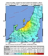
The Chūetsu Offshore Earthquake was a powerful magnitude
6.6 earthquake
that occurred 10:13 a.m. local time
(01:13 UTC
) on July 16, 2007, in the northwest Niigata region
of Japan. The earthquake shook Niigata and neighbouring prefectures. The city of Kashiwazaki
and the villages of Iizuna
and Kariwa
registered the highest seismic intensity
of a strong 6 on Japan's shindo scale
, but the quake was felt as far away as Tokyo. Eleven deaths and at least 1000 injuries were reported, and 342 buildings were completely destroyed, mostly older wooden structures.
Prime Minister
Shinzō Abe
broke off from his election campaign in Southern Japan to visit Kashiwazaki and promised to "make every effort towards rescue and also to restore services such as gas and electricity".
This magnitude 6.6 earthquake occurred approximately 15 miles off the west coast of Honshū
, Japan, in a zone of compressional deformation that is associated with the boundary between the Amur plate and the Okhotsk plate. At this latitude, the Okhotsk Plate
is converging to the west-northwest towards the Amur Plate with a velocity of about 9 mm/yr. The Amur and Okhotsk plate are themselves relatively small plates that lie between the Eurasian Plate
and the Pacific Plate
. The Pacific plate converges west-northwest towards the Eurasia plate at over 90 mm/yr. Most of the relative motion between the Pacific plate and the Eurasia plate is accommodated approximately 400 km to the east-southeast of the epicenter of the earthquake, where the Pacific plate subducts beneath the Okhotsk plate.
This shallow crustal earthquake was followed 13 hours later by a deep focus magnitude 6.8 quake roughly 330 km to the west, 350 km below the Sea of Japan
. The two earthquakes were generated by different mechanisms. The first earthquake was caused by deformation within the crust of the Okhotsk plate and the second quake was likely caused by faulting resulting from internal deformation of the subducted Pacific plate. Given their different mechanisms and physical separation of at least 10 rupture lengths, the second earthquake is not considered an aftershock of the first.
Shallow earthquakes cause more damage than intermediate- and deep-focus ones since the energy generated by the shallow events is released closer to the surface and therefore produces stronger shaking than is produced by quakes that are deeper within the Earth. The peak ground acceleration
generated was 993 gal
(1.01 g).
Two days after the initial earthquake, an aftershock occurred, registering 4 shindo
in Izumozaki, Niigata
. Nissan also had to shut down two factories.
Production resumed in Toyota, Mazda, and Honda plants on July 25, after damaged equipment and gas and water supplies were restored. Toyota's production losses amounted to between 46,000 or possibly 55,000 vehicles. Nissan lossed 12,000 vehicles.
. A small amount of water from the spent fuel pool leaked out but plant operators said the leak was low and did not present any environmental danger.
The earthquake also caused a fire in an electrical transformer at the Kashiwazaki-Kariwa Nuclear Power Plant
but it was was extinguished after two hours.
The government requested that the plant remain closed pending safety inspections. The IAEA offered to send a team of experts to inspect the plant. The Japanese government initially declined the offer but later accepted it after Niigata Prefecture
legislature asked for confidence building efforts to counter public concern about the reactor.
The area, was hard hit by tourist cancellations due to fears relating to the plant.
Following the incident Dr Kiyoo Mogi
, chair of Japan's Coordinating Committee for Earthquake Prediction
, called for the immediate closure of the Hamaoka Nuclear Power Plant
, which was built close to the centre of the expected Tōkai earthquake
.
Richter magnitude scale
The expression Richter magnitude scale refers to a number of ways to assign a single number to quantify the energy contained in an earthquake....
6.6 earthquake
Earthquake
An earthquake is the result of a sudden release of energy in the Earth's crust that creates seismic waves. The seismicity, seismism or seismic activity of an area refers to the frequency, type and size of earthquakes experienced over a period of time...
that occurred 10:13 a.m. local time
Japan Standard Time
Japan Standard Time or JST is the standard timezone of Japan, and is 9 hours ahead of UTC. For example, when it is midnight in UTC, it is 09:00 in Japan Standard Time. There is no daylight saving time, though its introduction has been debated several times. Japan Standard Time is the same as...
(01:13 UTC
Coordinated Universal Time
Coordinated Universal Time is the primary time standard by which the world regulates clocks and time. It is one of several closely related successors to Greenwich Mean Time. Computer servers, online services and other entities that rely on having a universally accepted time use UTC for that purpose...
) on July 16, 2007, in the northwest Niigata region
Niigata Prefecture
is a prefecture of Japan located on the island of Honshū on the coast of the Sea of Japan. The capital is the city of Niigata. The name "Niigata" literally means "new lagoon".- History :...
of Japan. The earthquake shook Niigata and neighbouring prefectures. The city of Kashiwazaki
Kashiwazaki, Niigata
is a city located in Niigata, Japan.As of May 1, 2008, the city has an estimated population of 92,947 and the density of 210 persons per km². The total area is 442.70 km²....
and the villages of Iizuna
Iizuna, Nagano
is a town located in the north side of Nagano City, Kamiminochi District, Nagano, Japan.The town was created through a merger of the villages of Samizu and Mure on October 1, 2005....
and Kariwa
Kariwa, Niigata
is a village located in Kariwa District, Niigata, Japan.As of March 31, 2007, the village has a population of 4,997 and a density of 190.14 persons per km²...
registered the highest seismic intensity
Japan Meteorological Agency seismic intensity scale
The Japan Meteorological Agency seismic intensity scale is a seismic scale used in Japan and Taiwan to measure the intensity of earthquakes. It is measured in units of...
of a strong 6 on Japan's shindo scale
Japan Meteorological Agency seismic intensity scale
The Japan Meteorological Agency seismic intensity scale is a seismic scale used in Japan and Taiwan to measure the intensity of earthquakes. It is measured in units of...
, but the quake was felt as far away as Tokyo. Eleven deaths and at least 1000 injuries were reported, and 342 buildings were completely destroyed, mostly older wooden structures.
Prime Minister
Prime Minister of Japan
The is the head of government of Japan. He is appointed by the Emperor of Japan after being designated by the Diet from among its members, and must enjoy the confidence of the House of Representatives to remain in office...
Shinzō Abe
Shinzo Abe
was the 90th Prime Minister of Japan, elected by a special session of the National Diet on 26 September 2006. He was Japan's youngest post–World War II prime minister and the first born after the war. Abe served as prime minister for nearly twelve months, before resigning on 12 September 2007...
broke off from his election campaign in Southern Japan to visit Kashiwazaki and promised to "make every effort towards rescue and also to restore services such as gas and electricity".
Tectonic summary
This magnitude 6.6 earthquake occurred approximately 15 miles off the west coast of Honshū
Honshu
is the largest island of Japan. The nation's main island, it is south of Hokkaido across the Tsugaru Strait, north of Shikoku across the Inland Sea, and northeast of Kyushu across the Kanmon Strait...
, Japan, in a zone of compressional deformation that is associated with the boundary between the Amur plate and the Okhotsk plate. At this latitude, the Okhotsk Plate
Okhotsk Plate
The Okhotsk Plate is a tectonic plate covering the Sea of Okhotsk, the Kamchatka Peninsula, Sakhalin Island and Tōhoku and Hokkaidō in Japan. It was formerly considered a part of the North American Plate, but recent studies indicate that it is an independent plate, bounded on the north by the...
is converging to the west-northwest towards the Amur Plate with a velocity of about 9 mm/yr. The Amur and Okhotsk plate are themselves relatively small plates that lie between the Eurasian Plate
Eurasian Plate
The Eurasian Plate is a tectonic plate which includes most of the continent of Eurasia , with the notable exceptions of the Indian subcontinent, the Arabian subcontinent, and the area east of the Chersky Range in East Siberia...
and the Pacific Plate
Pacific Plate
The Pacific Plate is an oceanic tectonic plate that lies beneath the Pacific Ocean. At 103 million square kilometres, it is the largest tectonic plate....
. The Pacific plate converges west-northwest towards the Eurasia plate at over 90 mm/yr. Most of the relative motion between the Pacific plate and the Eurasia plate is accommodated approximately 400 km to the east-southeast of the epicenter of the earthquake, where the Pacific plate subducts beneath the Okhotsk plate.
This shallow crustal earthquake was followed 13 hours later by a deep focus magnitude 6.8 quake roughly 330 km to the west, 350 km below the Sea of Japan
Sea of Japan
The Sea of Japan is a marginal sea of the western Pacific Ocean, between the Asian mainland, the Japanese archipelago and Sakhalin. It is bordered by Japan, North Korea, Russia and South Korea. Like the Mediterranean Sea, it has almost no tides due to its nearly complete enclosure from the Pacific...
. The two earthquakes were generated by different mechanisms. The first earthquake was caused by deformation within the crust of the Okhotsk plate and the second quake was likely caused by faulting resulting from internal deformation of the subducted Pacific plate. Given their different mechanisms and physical separation of at least 10 rupture lengths, the second earthquake is not considered an aftershock of the first.
Shallow earthquakes cause more damage than intermediate- and deep-focus ones since the energy generated by the shallow events is released closer to the surface and therefore produces stronger shaking than is produced by quakes that are deeper within the Earth. The peak ground acceleration
Peak ground acceleration
Peak ground acceleration is a measure of earthquake acceleration on the ground and an important input parameter for earthquake engineering, also known as the design basis earthquake ground motion...
generated was 993 gal
Gal (unit)
The gal, sometimes called galileo, is a unit of acceleration used extensively in the science of gravimetry. The gal is defined as 1 centimeter per second squared ....
(1.01 g).
Two days after the initial earthquake, an aftershock occurred, registering 4 shindo
Japan Meteorological Agency seismic intensity scale
The Japan Meteorological Agency seismic intensity scale is a seismic scale used in Japan and Taiwan to measure the intensity of earthquakes. It is measured in units of...
in Izumozaki, Niigata
Izumozaki, Niigata
is a town located in Santō District, Niigata, Japan.As of 2003, the town has an estimated population of 5,565 and a density of 125.39 persons per km². The total area is 44.38 km².-External links:*...
Automotive production
Toyota motor announced it stopped production in all of its factories because of the damage done to the Riken parts plant in Kashiwazaki, NiigataKashiwazaki, Niigata
is a city located in Niigata, Japan.As of May 1, 2008, the city has an estimated population of 92,947 and the density of 210 persons per km². The total area is 442.70 km²....
. Nissan also had to shut down two factories.
Production resumed in Toyota, Mazda, and Honda plants on July 25, after damaged equipment and gas and water supplies were restored. Toyota's production losses amounted to between 46,000 or possibly 55,000 vehicles. Nissan lossed 12,000 vehicles.
Kashiwazaki-Kariwa Nuclear Power Plant incidents
The earthquake also caused a leak of radioactive gases from Kashiwazaki-Kariwa Nuclear Power PlantKashiwazaki-Kariwa Nuclear Power Plant
The is a large, modern nuclear power plant on a 4.2-square-kilometer site including land in the towns of Kashiwazaki and Kariwa in Niigata Prefecture, Japan on the coast of the Sea of Japan, from where it gets cooling water...
. A small amount of water from the spent fuel pool leaked out but plant operators said the leak was low and did not present any environmental danger.
The earthquake also caused a fire in an electrical transformer at the Kashiwazaki-Kariwa Nuclear Power Plant
Kashiwazaki-Kariwa Nuclear Power Plant
The is a large, modern nuclear power plant on a 4.2-square-kilometer site including land in the towns of Kashiwazaki and Kariwa in Niigata Prefecture, Japan on the coast of the Sea of Japan, from where it gets cooling water...
but it was was extinguished after two hours.
The government requested that the plant remain closed pending safety inspections. The IAEA offered to send a team of experts to inspect the plant. The Japanese government initially declined the offer but later accepted it after Niigata Prefecture
Niigata Prefecture
is a prefecture of Japan located on the island of Honshū on the coast of the Sea of Japan. The capital is the city of Niigata. The name "Niigata" literally means "new lagoon".- History :...
legislature asked for confidence building efforts to counter public concern about the reactor.
The area, was hard hit by tourist cancellations due to fears relating to the plant.
Following the incident Dr Kiyoo Mogi
Kiyoo Mogi
Dr is a prominent seismologist. He is regarded as Japan's foremost authority on earthquake prediction and is a former chair of the Japanese Coordinating Committee for Earthquake Prediction . Mogi is also a former Director of the University of Tokyo's Earthquake Research Institute, was a professor...
, chair of Japan's Coordinating Committee for Earthquake Prediction
Coordinating Committee for Earthquake Prediction
The Coordinating Committee for Earthquake Prediction in Japan was founded in April 1969, as part of the Geodesy Council's Second Earthquake Prediction Plan, in order to carry out a comprehensive evaluation of earthquake data in Japan. The committee consists of 30 members and meets four times each...
, called for the immediate closure of the Hamaoka Nuclear Power Plant
Hamaoka Nuclear Power Plant
The is a nuclear power plant located in Omaezaki city, Shizuoka Prefecture, on Japan's east coast, 200 km south-west of Tokyo. It is managed by the Chubu Electric Power Company. There are five units contained at a single site with a net area of 1.6 km2 . A sixth unit began construction...
, which was built close to the centre of the expected Tōkai earthquake
Tokai earthquakes
The Tōkai earthquakes are major earthquakes that have occurred regularly with an interval of 100 to 150 years in the Tōkai region of Japan. The Tokai segment has been struck by earthquakes in 1498, 1605, 1707 and 1854...
.
See also
- 2007 Noto earthquake2007 Noto earthquakeAt 9:42 a.m. on March 25, 2007, the , a magnitude 6.9 earthquake, struck the Hokuriku region of Japan, near the Noto Peninsula. The earthquake shook the city of Nanao and the town of Anamizu with a seismic intensity of 6+ on Japan's shindo scale. One death, in the city of Wajima, and at least 214...
- 2004 Chūetsu earthquake2004 Chuetsu earthquakeThe occurred at 5:56 p.m. on Saturday, October 23, 2004 . The Japan Meteorological Agency has named it the Heisei 16 Niigata Prefecture Chuetsu Earthquake or The Mid Niigata Prefecture Earthquake of 2004...
- Great Hanshin earthquakeGreat Hanshin earthquakeThe Great Hanshin earthquake, or Kobe earthquake, was an earthquake that occurred on Tuesday, January 17, 1995, at 05:46 JST in the southern part of Hyōgo Prefecture, Japan. It measured 6.8 on the moment magnitude scale , and Mj7.3 on JMA magnitude scale. The tremors lasted for approximately 20...
- 2011 Tōhoku earthquake and tsunami2011 Tōhoku earthquake and tsunamiThe 2011 earthquake off the Pacific coast of Tohoku, also known as the 2011 Tohoku earthquake, or the Great East Japan Earthquake, was a magnitude 9.0 undersea megathrust earthquake off the coast of Japan that occurred at 14:46 JST on Friday, 11 March 2011, with the epicenter approximately east...