
2002 Oman cyclone
Encyclopedia
The 2002 Oman cyclone (JTWC designation: 01A, officially known as Cyclonic Storm ARB 01) was an uncommon tropical cyclone
that struck the Dhofar
region of Oman
in May 2002. The first storm in the 2002 North Indian Ocean cyclone season
, it developed on May 6 in the Arabian Sea
, and it maintained a general west-northwest track for much of its duration. The system reached cyclonic storm status on May 9, meaning it attained winds of greater than 65 km/h (40 mph), and on May 10 it made landfall
near Salalah
; shortly thereafter it dissipated. The storm was rare, in that it was one of only eleven tropical cyclones on record to approach the Arabian Peninsula in the month of May.
The storm brought the heaviest rainfall totals to Dhofar in 30 years, causing flooding and creating rivers in wadi
s, or typically dry riverbeds. Several people drowned after their vehicles were swept away by the flooding. The storm caused locally heavy damage, totaling $25 million (2002 USD, $30 million 2008 USD).
developed on May 2, 2002 near Sri Lanka
, associated with a weak and broad circulation center. The system tracked west-northwestward through the Arabian Sea
along a trough
. Its thunderstorm activity was enhanced by a ridge
to its north, though was also removed from the center. By May 5, the circulation had become better defined, and concurrently the convection increased over the center. After further organization, the India Meteorological Department
(IMD) classified the system as Depression ARB01A on May 6. Around the same time, the Joint Typhoon Warning Center
(JTWC) classified it as Tropical Depression 01A, while located about 1300 km (800 mi) southeast of Salalah
, Oman
.
After becoming a tropical cyclone, the depression turned to a northwest motion before resuming a track to the west-northwest. On May 7 it intensified into a deep depression
, and though its winds had increased, the structure became disorganized as the center became exposed from the thunderstorm activity. The convection waned, due to the influence of dry air from the Arabian Peninsula
, as well as from wind shear
. As a result, the IMD downgraded it to depression status early on May 8. However, later in the day, convection redeveloped over the western half of the circulation, and it again reached deep depression status, about 830 km (515 mi) southeast of Oman.
The storm maintained poleward outflow
as it continued west-northwestward, which allowed for some further development. Deep convection increased in coverage, though partially removed from the center, and early on May 9 the IMD upgraded the system to a cyclonic storm
. Around that time, the storm was estimated by the JTWC to have attained peak winds of 85 km/h (50 km/h), with an atmospheric pressure
of 991 mbar
. While located a short distance offshore, the storm turned to the northwest and weakened slightly. At about 0900 UTC
on May 10, the storm made landfall
near Salalah, Oman, with a pressure of 995 mbar and sustained winds of 80 km/h (50 mph); shortly thereafter it began dissipation
over Oman.
Its landfall in the Dhofar
region of Oman was uncommon; in the period from 1891 to 1990, only 17 tropical depressions or storms struck the region.
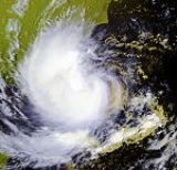
.jpg) Along the coastline, the arrival of the storm resulted in strong waves of up to 4 metres (13 ft). The storm dropped heavy rainfall in the vicinity of its landfall, which were the greatest totals in 30 years in the Dhofar
Along the coastline, the arrival of the storm resulted in strong waves of up to 4 metres (13 ft). The storm dropped heavy rainfall in the vicinity of its landfall, which were the greatest totals in 30 years in the Dhofar
region. The city of Salalah reported 58 mm (2.28 in) in a 24 hour period as the storm moved ashore, which was more than 300% of its average monthly for May. As a result, some flooding was reported in the city, and several wadi
s, or typically dry riverbeds, became sudden rivers in the area; one station recorded a discharge
of 1146 m3/s (40,470 ft3/s). In Qairoon, precipitation amounted to 251 mm (9.88 in), which was the highest total in Oman. Severe thunderstorms were reported during its passage, with wind gusts peaking at 106 km/h (66 mph). In neighboring Yemen
, the city of Al Ghaydah
reported light winds of about 45 km/h (30 mph).
Damage was severe and widespread, estimated at $25 million (2002 USD, $30 million 2008 USD). Storm impact included property, crop, transportation, and agricultural damage, with hundreds of cattle drowning during the passage of the storm. Across the Dhofar
region of Oman, the storm caused several injuries and a total of nine fatalities; most of the deaths were drownings, occurring when their vehicles were swept away by flooding in typically dry areas. Two army soldiers and one police officer drowned while saving other people in danger.
In the aftermath of the storm, the Omani government received 4,000 requests for assistance, and in turn provided financial aid to 500 families; additionally, the government supplied temporary housing for displaced people.
Tropical cyclone
A tropical cyclone is a storm system characterized by a large low-pressure center and numerous thunderstorms that produce strong winds and heavy rain. Tropical cyclones strengthen when water evaporated from the ocean is released as the saturated air rises, resulting in condensation of water vapor...
that struck the Dhofar
Dhofar
The Dhofar region lies in Southern Oman, on the eastern border with Yemen. Its mountainous area covers and has a population of 215,960 as of the 2003 census. The largest town in the region is Salalah. Historically, it was the chief source of frankincense in the world. However, its frankincense...
region of Oman
Oman
Oman , officially called the Sultanate of Oman , is an Arab state in southwest Asia on the southeast coast of the Arabian Peninsula. It is bordered by the United Arab Emirates to the northwest, Saudi Arabia to the west, and Yemen to the southwest. The coast is formed by the Arabian Sea on the...
in May 2002. The first storm in the 2002 North Indian Ocean cyclone season
2002 North Indian Ocean cyclone season
The 2002 North Indian Ocean cyclone season had no bounds, but cyclones tend to form between April and December, with peaks in May and November. These dates conventionally delimit the period of each year when most tropical cyclones form in the northern Indian Ocean.-Season summary:Four tropical...
, it developed on May 6 in the Arabian Sea
Arabian Sea
The Arabian Sea is a region of the Indian Ocean bounded on the east by India, on the north by Pakistan and Iran, on the west by the Arabian Peninsula, on the south, approximately, by a line between Cape Guardafui in northeastern Somalia and Kanyakumari in India...
, and it maintained a general west-northwest track for much of its duration. The system reached cyclonic storm status on May 9, meaning it attained winds of greater than 65 km/h (40 mph), and on May 10 it made landfall
Landfall (meteorology)
Landfall is the event of a tropical cyclone or a waterspout coming onto land after being over water. When a waterspout makes landfall it is reclassified as a tornado, which can then cause damage inland...
near Salalah
Salalah
Salalah , is the capital and seat of the governor or Wali of the southern Omani province of Dhofar. The population of Salalah was 197,169 in 2009....
; shortly thereafter it dissipated. The storm was rare, in that it was one of only eleven tropical cyclones on record to approach the Arabian Peninsula in the month of May.
The storm brought the heaviest rainfall totals to Dhofar in 30 years, causing flooding and creating rivers in wadi
Wadi
Wadi is the Arabic term traditionally referring to a valley. In some cases, it may refer to a dry riverbed that contains water only during times of heavy rain or simply an intermittent stream.-Variant names:...
s, or typically dry riverbeds. Several people drowned after their vehicles were swept away by the flooding. The storm caused locally heavy damage, totaling $25 million (2002 USD, $30 million 2008 USD).
Meteorological history
An area of convectionConvection
Convection is the movement of molecules within fluids and rheids. It cannot take place in solids, since neither bulk current flows nor significant diffusion can take place in solids....
developed on May 2, 2002 near Sri Lanka
Sri Lanka
Sri Lanka, officially the Democratic Socialist Republic of Sri Lanka is a country off the southern coast of the Indian subcontinent. Known until 1972 as Ceylon , Sri Lanka is an island surrounded by the Indian Ocean, the Gulf of Mannar and the Palk Strait, and lies in the vicinity of India and the...
, associated with a weak and broad circulation center. The system tracked west-northwestward through the Arabian Sea
Arabian Sea
The Arabian Sea is a region of the Indian Ocean bounded on the east by India, on the north by Pakistan and Iran, on the west by the Arabian Peninsula, on the south, approximately, by a line between Cape Guardafui in northeastern Somalia and Kanyakumari in India...
along a trough
Trough (meteorology)
A trough is an elongated region of relatively low atmospheric pressure, often associated with fronts.Unlike fronts, there is not a universal symbol for a trough on a weather chart. The weather charts in some countries or regions mark troughs by a line. In the United States, a trough may be marked...
. Its thunderstorm activity was enhanced by a ridge
Ridge (meteorology)
A ridge is an elongated region of relatively high atmospheric pressure, the opposite of a trough....
to its north, though was also removed from the center. By May 5, the circulation had become better defined, and concurrently the convection increased over the center. After further organization, the India Meteorological Department
India Meteorological Department
The India Meteorological Department , also referred to as the Met Office, is an agency of the Ministry of Earth Sciences of the Government of India. It is the principal agency responsible for meteorological observations, weather forecasting and seismology...
(IMD) classified the system as Depression ARB01A on May 6. Around the same time, the Joint Typhoon Warning Center
Joint Typhoon Warning Center
The Joint Typhoon Warning Center is a joint United States Navy – United States Air Force task force located at the Naval Maritime Forecast Center in Pearl Harbor, Hawaii...
(JTWC) classified it as Tropical Depression 01A, while located about 1300 km (800 mi) southeast of Salalah
Salalah
Salalah , is the capital and seat of the governor or Wali of the southern Omani province of Dhofar. The population of Salalah was 197,169 in 2009....
, Oman
Oman
Oman , officially called the Sultanate of Oman , is an Arab state in southwest Asia on the southeast coast of the Arabian Peninsula. It is bordered by the United Arab Emirates to the northwest, Saudi Arabia to the west, and Yemen to the southwest. The coast is formed by the Arabian Sea on the...
.
After becoming a tropical cyclone, the depression turned to a northwest motion before resuming a track to the west-northwest. On May 7 it intensified into a deep depression
Tropical cyclone scales
Tropical systems are officially ranked on one of several tropical cyclone scales according to their maximum sustained winds and in what oceanic basin they are located...
, and though its winds had increased, the structure became disorganized as the center became exposed from the thunderstorm activity. The convection waned, due to the influence of dry air from the Arabian Peninsula
Arabian Peninsula
The Arabian Peninsula is a land mass situated north-east of Africa. Also known as Arabia or the Arabian subcontinent, it is the world's largest peninsula and covers 3,237,500 km2...
, as well as from wind shear
Wind shear
Wind shear, sometimes referred to as windshear or wind gradient, is a difference in wind speed and direction over a relatively short distance in the atmosphere...
. As a result, the IMD downgraded it to depression status early on May 8. However, later in the day, convection redeveloped over the western half of the circulation, and it again reached deep depression status, about 830 km (515 mi) southeast of Oman.
The storm maintained poleward outflow
Outflow (meteorology)
Outflow, in meteorology, is air that flows outwards from a storm system. It is associated with ridging, or anticyclonic flow. In the low levels of the troposphere, outflow radiates from thunderstorms in the form of a wedge of rain-cooled air, which is visible as a thin rope-like cloud on weather...
as it continued west-northwestward, which allowed for some further development. Deep convection increased in coverage, though partially removed from the center, and early on May 9 the IMD upgraded the system to a cyclonic storm
Tropical cyclone scales
Tropical systems are officially ranked on one of several tropical cyclone scales according to their maximum sustained winds and in what oceanic basin they are located...
. Around that time, the storm was estimated by the JTWC to have attained peak winds of 85 km/h (50 km/h), with an atmospheric pressure
Atmospheric pressure
Atmospheric pressure is the force per unit area exerted into a surface by the weight of air above that surface in the atmosphere of Earth . In most circumstances atmospheric pressure is closely approximated by the hydrostatic pressure caused by the weight of air above the measurement point...
of 991 mbar
Bar (unit)
The bar is a unit of pressure equal to 100 kilopascals, and roughly equal to the atmospheric pressure on Earth at sea level. Other units derived from the bar are the megabar , kilobar , decibar , centibar , and millibar...
. While located a short distance offshore, the storm turned to the northwest and weakened slightly. At about 0900 UTC
Coordinated Universal Time
Coordinated Universal Time is the primary time standard by which the world regulates clocks and time. It is one of several closely related successors to Greenwich Mean Time. Computer servers, online services and other entities that rely on having a universally accepted time use UTC for that purpose...
on May 10, the storm made landfall
Landfall (meteorology)
Landfall is the event of a tropical cyclone or a waterspout coming onto land after being over water. When a waterspout makes landfall it is reclassified as a tornado, which can then cause damage inland...
near Salalah, Oman, with a pressure of 995 mbar and sustained winds of 80 km/h (50 mph); shortly thereafter it began dissipation
Dissipation
In physics, dissipation embodies the concept of a dynamical system where important mechanical models, such as waves or oscillations, lose energy over time, typically from friction or turbulence. The lost energy converts into heat, which raises the temperature of the system. Such systems are called...
over Oman.
Its landfall in the Dhofar
Dhofar
The Dhofar region lies in Southern Oman, on the eastern border with Yemen. Its mountainous area covers and has a population of 215,960 as of the 2003 census. The largest town in the region is Salalah. Historically, it was the chief source of frankincense in the world. However, its frankincense...
region of Oman was uncommon; in the period from 1891 to 1990, only 17 tropical depressions or storms struck the region.
Impact
Dhofar
The Dhofar region lies in Southern Oman, on the eastern border with Yemen. Its mountainous area covers and has a population of 215,960 as of the 2003 census. The largest town in the region is Salalah. Historically, it was the chief source of frankincense in the world. However, its frankincense...
region. The city of Salalah reported 58 mm (2.28 in) in a 24 hour period as the storm moved ashore, which was more than 300% of its average monthly for May. As a result, some flooding was reported in the city, and several wadi
Wadi
Wadi is the Arabic term traditionally referring to a valley. In some cases, it may refer to a dry riverbed that contains water only during times of heavy rain or simply an intermittent stream.-Variant names:...
s, or typically dry riverbeds, became sudden rivers in the area; one station recorded a discharge
Discharge (hydrology)
In hydrology, discharge is the volume rate of water flow, including any suspended solids , dissolved chemical species and/or biologic material , which is transported through a given cross-sectional area...
of 1146 m3/s (40,470 ft3/s). In Qairoon, precipitation amounted to 251 mm (9.88 in), which was the highest total in Oman. Severe thunderstorms were reported during its passage, with wind gusts peaking at 106 km/h (66 mph). In neighboring Yemen
Yemen
The Republic of Yemen , commonly known as Yemen , is a country located in the Middle East, occupying the southwestern to southern end of the Arabian Peninsula. It is bordered by Saudi Arabia to the north, the Red Sea to the west, and Oman to the east....
, the city of Al Ghaydah
Al Ghaydah
Al Ghaydah is the capital city of Al Mahrah Governorate in southeastern Yemen. It is located at around ....
reported light winds of about 45 km/h (30 mph).
Damage was severe and widespread, estimated at $25 million (2002 USD, $30 million 2008 USD). Storm impact included property, crop, transportation, and agricultural damage, with hundreds of cattle drowning during the passage of the storm. Across the Dhofar
Dhofar
The Dhofar region lies in Southern Oman, on the eastern border with Yemen. Its mountainous area covers and has a population of 215,960 as of the 2003 census. The largest town in the region is Salalah. Historically, it was the chief source of frankincense in the world. However, its frankincense...
region of Oman, the storm caused several injuries and a total of nine fatalities; most of the deaths were drownings, occurring when their vehicles were swept away by flooding in typically dry areas. Two army soldiers and one police officer drowned while saving other people in danger.
In the aftermath of the storm, the Omani government received 4,000 requests for assistance, and in turn provided financial aid to 500 families; additionally, the government supplied temporary housing for displaced people.