
1997 North Indian Ocean cyclone season
Encyclopedia
The 1997 North Indian Ocean cyclone season had no bounds, but cyclones tend to form between April and December, with peaks in May and November. These dates conventionally delimit the period of each year when most tropical cyclones form in the northern Indian Ocean
.
ial trough
developed. The poorly organized system slowly tracked towards the north-northwest. The following day, deep convection
consolidated around the center of circulation
and the Joint Typhoon Warning Center
(JTWC) classified the system as Tropical Cyclone 01B. Favorable upper-level conditions and good outflow
allowed the storm to intensify. Shortly after, the cyclone attained tropical storm-force winds and turned towards the northeast. While gradually increasing in forward motion, the storm continued to strengthen. On May 17, the cyclone attained winds of 120 km/h (75 km/h), equivalent to a Category 1 hurricane on the Saffir-Simpson Hurricane Scale
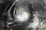
. By May 18 an eye
developed and the storm reached its peak intensity with winds of 215 km/h (135 mph) before making landfall near Chittagong
. After landfall, the storm rapidly tracked northeastward inland and dissipated early on May 20.
causing significant damage and 67 fatalities
. It drifted southward, northward, then westward over India. On the 10th, it was upgraded to a tropical storm over the Arabian Sea, and it reached its peak of 65 mi/h winds the next day. Wind shear caused the storm to dissipate over the open waters on the 14th.
, it restrengthened to a tropical storm. Tropical Storm Three dissipated on the 10th without causing any reported damage.
, emerged into the Bay of Bengal on November 4. It continued westward, reaching cyclone strength again, but vertical shear caused it to dissipate on the 9th.
In southern Thailand
, 30 people were killed and 102 others were listed as missing as a result of the storm. Linda damaged at least 100 homes and sank 30 ships in the region. An estimated 6,400,000 m2 of farmland were destroyed by Linda.
Indian Ocean
The Indian Ocean is the third largest of the world's oceanic divisions, covering approximately 20% of the water on the Earth's surface. It is bounded on the north by the Indian Subcontinent and Arabian Peninsula ; on the west by eastern Africa; on the east by Indochina, the Sunda Islands, and...
.
Season summary
Five tropical cyclones were observed, making 1997 an average season. However, 3 reached Cyclone strength.Very Severe Tropical Cyclone BOB 01 (01B)
On May 13, a near-equatorEquator
An equator is the intersection of a sphere's surface with the plane perpendicular to the sphere's axis of rotation and containing the sphere's center of mass....
ial trough
Low pressure area
A low-pressure area, or "low", is a region where the atmospheric pressure at sea level is below that of surrounding locations. Low-pressure systems form under areas of wind divergence which occur in upper levels of the troposphere. The formation process of a low-pressure area is known as...
developed. The poorly organized system slowly tracked towards the north-northwest. The following day, deep convection
Atmospheric convection
Atmospheric convection is the result of a parcel-environment instability, or temperature difference, layer in the atmosphere. Different lapse rates within dry and moist air lead to instability. Mixing of air during the day which expands the height of the planetary boundary layer leads to...
consolidated around the center of circulation
Eye (cyclone)
The eye is a region of mostly calm weather found at the center of strong tropical cyclones. The eye of a storm is a roughly circular area and typically 30–65 km in diameter. It is surrounded by the eyewall, a ring of towering thunderstorms where the second most severe weather of a cyclone...
and the Joint Typhoon Warning Center
Joint Typhoon Warning Center
The Joint Typhoon Warning Center is a joint United States Navy – United States Air Force task force located at the Naval Maritime Forecast Center in Pearl Harbor, Hawaii...
(JTWC) classified the system as Tropical Cyclone 01B. Favorable upper-level conditions and good outflow
Outflow (meteorology)
Outflow, in meteorology, is air that flows outwards from a storm system. It is associated with ridging, or anticyclonic flow. In the low levels of the troposphere, outflow radiates from thunderstorms in the form of a wedge of rain-cooled air, which is visible as a thin rope-like cloud on weather...
allowed the storm to intensify. Shortly after, the cyclone attained tropical storm-force winds and turned towards the northeast. While gradually increasing in forward motion, the storm continued to strengthen. On May 17, the cyclone attained winds of 120 km/h (75 km/h), equivalent to a Category 1 hurricane on the Saffir-Simpson Hurricane Scale
Saffir-Simpson Hurricane Scale
The Saffir–Simpson Hurricane Scale , or the Saffir–Simpson Hurricane Wind Scale , classifies hurricanes — Western Hemisphere tropical cyclones that exceed the intensities of tropical depressions and tropical storms — into five categories distinguished by the intensities of their sustained winds...
. By May 18 an eye
Eye (cyclone)
The eye is a region of mostly calm weather found at the center of strong tropical cyclones. The eye of a storm is a roughly circular area and typically 30–65 km in diameter. It is surrounded by the eyewall, a ring of towering thunderstorms where the second most severe weather of a cyclone...
developed and the storm reached its peak intensity with winds of 215 km/h (135 mph) before making landfall near Chittagong
Chittagong
Chittagong ) is a city in southeastern Bangladesh and the capital of an eponymous district and division. Built on the banks of the Karnaphuli River, the city is home to Bangladesh's busiest seaport and has a population of over 4.5 million, making it the second largest city in the country.A trading...
. After landfall, the storm rapidly tracked northeastward inland and dissipated early on May 20.
causing significant damage and 67 fatalities
Severe Tropical Cyclone 02B
On September 19, a tropical depression formed from an area of disturbed weather in the western Bay of Bengal. It drifted northwestward towards the Indian coastline, but a mid-latitude trough pulled it northeastward, The depression strengthened to a tropical storm on the 24th, and it reached cyclone strength while paralleling the Indian coastline on 26th. It made landfall in Bangladesh on the 27th, and dissipated shortly thereafter. Tropical Cyclone Cyclone 2B was responsible for 51 fatalities and left an additional 137 people missing.Deep Depression 04A
On November 2 a tropical depression developed into a tropical depression over Sri LankaSri Lanka
Sri Lanka, officially the Democratic Socialist Republic of Sri Lanka is a country off the southern coast of the Indian subcontinent. Known until 1972 as Ceylon , Sri Lanka is an island surrounded by the Indian Ocean, the Gulf of Mannar and the Palk Strait, and lies in the vicinity of India and the...
. It drifted southward, northward, then westward over India. On the 10th, it was upgraded to a tropical storm over the Arabian Sea, and it reached its peak of 65 mi/h winds the next day. Wind shear caused the storm to dissipate over the open waters on the 14th.
Deep Depression 03A
A broad trough of low pressure formed into a tropical depression on November 4 in the central Arabian Sea. It moved westward, slowly intensifying into a tropical storm on the 8th. Vertical shear weakened it to a depression later that day, but on the 9th, just before making landfall on eastern SomaliaSomalia
Somalia , officially the Somali Republic and formerly known as the Somali Democratic Republic under Socialist rule, is a country located in the Horn of Africa. Since the outbreak of the Somali Civil War in 1991 there has been no central government control over most of the country's territory...
, it restrengthened to a tropical storm. Tropical Storm Three dissipated on the 10th without causing any reported damage.
Cyclonic Storm Linda
Typhoon Linda killed 30 while crossing the Malay PeninsulaMalay Peninsula
The Malay Peninsula or Thai-Malay Peninsula is a peninsula in Southeast Asia. The land mass runs approximately north-south and, at its terminus, is the southern-most point of the Asian mainland...
, emerged into the Bay of Bengal on November 4. It continued westward, reaching cyclone strength again, but vertical shear caused it to dissipate on the 9th.
In southern Thailand
Thailand
Thailand , officially the Kingdom of Thailand , formerly known as Siam , is a country located at the centre of the Indochina peninsula and Southeast Asia. It is bordered to the north by Burma and Laos, to the east by Laos and Cambodia, to the south by the Gulf of Thailand and Malaysia, and to the...
, 30 people were killed and 102 others were listed as missing as a result of the storm. Linda damaged at least 100 homes and sank 30 ships in the region. An estimated 6,400,000 m2 of farmland were destroyed by Linda.
See also
- List of North Indian Ocean cyclone seasons
- List of tropical cyclones
- Tropical cycloneTropical cycloneA tropical cyclone is a storm system characterized by a large low-pressure center and numerous thunderstorms that produce strong winds and heavy rain. Tropical cyclones strengthen when water evaporated from the ocean is released as the saturated air rises, resulting in condensation of water vapor...
- Saffir-Simpson Hurricane ScaleSaffir-Simpson Hurricane ScaleThe Saffir–Simpson Hurricane Scale , or the Saffir–Simpson Hurricane Wind Scale , classifies hurricanes — Western Hemisphere tropical cyclones that exceed the intensities of tropical depressions and tropical storms — into five categories distinguished by the intensities of their sustained winds...
- 1997 Atlantic hurricane season1997 Atlantic hurricane seasonThe 1997 Atlantic hurricane season is the most recent Atlantic hurricane season to feature no tropical cyclones in August. The season officially began on June 1, 1997, and lasted until November 30, 1997...
- 1997 Pacific hurricane season1997 Pacific hurricane seasonThe 1997 Pacific hurricane season was a very active hurricane season. With hundreds of deaths and billions of dollars in damage, this season was the costliest and one of the deadliest Pacific hurricane seasons. This was due to a strong El Niño...
- 1997 Pacific typhoon season1997 Pacific typhoon seasonThe 1997 Pacific typhoon season has no official bounds; it ran year-round in 1997, but most tropical cyclones tend to form in the northwestern Pacific Ocean between May and November. These dates conventionally delimit the period of each year when most tropical cyclones form in the northwestern...
- South-West Indian Ocean cyclone seasons: 1996-971996-97 Southern Hemisphere tropical cyclone seasonThe 1996-97 Southern Hemisphere tropical cyclone season ran year-round from 1 July 1996 to 30 June 1997, reaching its peak mid-February to early March.1990-95 1995-96 1996-97 1997-98 1998-99-Storms:-Intense Tropical Cyclone Melanie-Bellamine:...
, 1997-981997-98 South-West Indian Ocean cyclone seasonThe 1997–98 South-West Indian Ocean cyclone season was an event in the annual cycle of tropical cyclone formation. It ran from November 15, 1997 to April 30, 1998, except for Mauritius and the Seychelles, where it ran until May 15. These dates conventionally delimit the period of each year when... - Australian region cyclone seasons: 1996-971996-97 Southern Hemisphere tropical cyclone seasonThe 1996-97 Southern Hemisphere tropical cyclone season ran year-round from 1 July 1996 to 30 June 1997, reaching its peak mid-February to early March.1990-95 1995-96 1996-97 1997-98 1998-99-Storms:-Intense Tropical Cyclone Melanie-Bellamine:...
, 1997-981997-98 Australian region cyclone seasonThe 1997–98 Australian region cyclone season was an event in the ongoing cycle of tropical cyclone formation. It ran from 1 November 1997 to 30 April 1998... - South Pacific cyclone seasons: 1996-971996-97 Southern Hemisphere tropical cyclone seasonThe 1996-97 Southern Hemisphere tropical cyclone season ran year-round from 1 July 1996 to 30 June 1997, reaching its peak mid-February to early March.1990-95 1995-96 1996-97 1997-98 1998-99-Storms:-Intense Tropical Cyclone Melanie-Bellamine:...
, 1997-981997-98 South Pacific cyclone seasonThe 1997–98 South Pacific cyclone season was one of the most active and the longest tropical cyclone seasons on record, with 16 tropical cyclones occurring within the South Pacific Ocean basin between 160°E and 120°W...