
1996 Pacific typhoon season
Encyclopedia
The 1996 Pacific typhoon season has no official bounds; it ran year-round in 1996, but most tropical cyclones tend to form in the northwestern Pacific Ocean
between May and November. These dates conventionally delimit the period of each year when most tropical cyclones form in the northwestern Pacific Ocean
.
The scope of this article is limited to the Pacific Ocean, north of the equator and west of the international date line
. Storms that form east of the date line and north of the equator are called hurricanes; see 1996 Pacific hurricane season
. Tropical Storms formed in the entire west pacific basin were assigned a name by the Joint Typhoon Warning Center
. Tropical depressions in this basin have the "W" suffix added to their number. Tropical depressions that enter or form in the Philippine area of responsibility are assigned a name by the Philippine Atmospheric, Geophysical and Astronomical Services Administration
or PAGASA. This can often result in the same storm having two names.
on the 18th. Rapidly weakening over the mountains, Eve turned eastward over the islands and the last warning was issued on the 20th. It restrengthened to a tropical storm east of Japan, and continued northeastward until dissipation on the 27th. Eve, despite being a Category 4 at landfall, caused no reported deaths and only 9 injuries.
on July 19. It tracked west-northwestward and became a tropical storm on the 21st. After crossing the island of Hainan
Frankie rapidly intensified to a 100 mph typhoon over the Gulf of Tonkin
. It northern Vietnam
on the 23rd, and dissipated 2 days later over China. 104 people were reported killed or missing in association with Frankie, and damage figures are estimated at over $200 million (1996 US Dollars).
. It headed northwestward, slowly organizing into a tropical storm on the 22nd. The next day Gloria reached typhoon strength, and a day later it reached its peak of 100 mph winds. Gloria brushed the northern coast of the Philippines and turned northward to hit Taiwan
on the 26th. After crossing the island and the Taiwan Straight, Gloria hit China where she dissipated on the 27th. Gloria caused 23 casualties, 20 of which were in the northern Philippines. In addition, damage was estimated at $20 million (1996 USD).
, Taiwan and People's Republic of China
. Maximum sustained wind
s of the cyclone
reached 160 miles per hour (257.5 km/h) over the open ocean. The system led to 590 casualties and US$5 billion in damage (1996 dollars).
. It weakened slightly yet steadily to a 115 mph typhoon over the South China Sea, hitting the Luichow Peninsula of China
on the 9th, and dissipated the next day over the country. Sally brought heavy rain and damage to China, causing 114 casualties, 110 people missing, and economic losses estimated at $1.5 billion (1996 USD).
on November 9. On November 10, Dale turned north, recurving east of the Philippines. On November 14, Dale accelerated east-northeast at more than 60 knots (117.6 km/h) as it became an extratropical cyclone
.
on the 25th. It continued east-southeastward until dissipation on the 27th, south of the Philippines. Greg caused extensive property damage on Borneo from torrential flooding, resulting in 127 deaths and 100 people missing.
. This was the first year the following names were used. The first storm of 1996 was named Ann and the final one was named Greg.
{|width="90%"
|
|
Pacific Ocean
The Pacific Ocean is the largest of the Earth's oceanic divisions. It extends from the Arctic in the north to the Southern Ocean in the south, bounded by Asia and Australia in the west, and the Americas in the east.At 165.2 million square kilometres in area, this largest division of the World...
between May and November. These dates conventionally delimit the period of each year when most tropical cyclones form in the northwestern Pacific Ocean
Pacific Ocean
The Pacific Ocean is the largest of the Earth's oceanic divisions. It extends from the Arctic in the north to the Southern Ocean in the south, bounded by Asia and Australia in the west, and the Americas in the east.At 165.2 million square kilometres in area, this largest division of the World...
.
The scope of this article is limited to the Pacific Ocean, north of the equator and west of the international date line
International Date Line
The International Date Line is a generally north-south imaginary line on the surface of the Earth, passing through the middle of the Pacific Ocean, that designates the place where each calendar day begins...
. Storms that form east of the date line and north of the equator are called hurricanes; see 1996 Pacific hurricane season
1996 Pacific hurricane season
The 1996 Pacific hurricane season was an event in tropical cyclone formation and the third least active Pacific hurricane season in recorded history, behind 1977 and 2010. It officially began May 15, 1996 in the eastern north Pacific and on June 1, 1996 in the central north Pacific. It ended on...
. Tropical Storms formed in the entire west pacific basin were assigned a name by the Joint Typhoon Warning Center
Joint Typhoon Warning Center
The Joint Typhoon Warning Center is a joint United States Navy – United States Air Force task force located at the Naval Maritime Forecast Center in Pearl Harbor, Hawaii...
. Tropical depressions in this basin have the "W" suffix added to their number. Tropical depressions that enter or form in the Philippine area of responsibility are assigned a name by the Philippine Atmospheric, Geophysical and Astronomical Services Administration
Philippine Atmospheric, Geophysical and Astronomical Services Administration
The Philippine Atmospheric, Geophysical and Astronomical Services Administration is a Philippine national institution dedicated to provide flood and typhoon warnings, public weather forecasts and advisories, meteorological, astronomical, climatological, and other specialized information and...
or PAGASA. This can often result in the same storm having two names.
Storms
The 1996 season was very active. Forty-four tropical cyclones formed this year, of which 33 became tropical storms. Twenty-one storms reached typhoon intensity, of which six reached super typhoon strength.Super Typhoon Eve
A Tropical Upper Tropospheric Trough spawned Tropical Depression 7W on July 10 over the open Western Pacific. It tracked generally west-northwestward, strengthening to a tropical storm on the 14th. On the 15th Eve became a typhoon, which was followed by a period of explosive deepening to a 100 mph Typhoon, with a pressure drop of 40 mb from early on the 15th to early on the 16th. An eyewall replacement cycle weakened Eve to a 95 mph typhoon, but as the outer eyewall contracted, the storm again reached wind speeds of 97 mph before hitting southern JapanJapan
Japan is an island nation in East Asia. Located in the Pacific Ocean, it lies to the east of the Sea of Japan, China, North Korea, South Korea and Russia, stretching from the Sea of Okhotsk in the north to the East China Sea and Taiwan in the south...
on the 18th. Rapidly weakening over the mountains, Eve turned eastward over the islands and the last warning was issued on the 20th. It restrengthened to a tropical storm east of Japan, and continued northeastward until dissipation on the 27th. Eve, despite being a Category 4 at landfall, caused no reported deaths and only 9 injuries.
Typhoon Frankie (Edeng)
An active monsoon trough over the Western Pacific Ocean developed 3 typhoons; Frankie, Gloria, and Herb. The first, Frankie, developed in the South China SeaSouth China Sea
The South China Sea is a marginal sea that is part of the Pacific Ocean, encompassing an area from the Singapore and Malacca Straits to the Strait of Taiwan of around...
on July 19. It tracked west-northwestward and became a tropical storm on the 21st. After crossing the island of Hainan
Hainan
Hainan is the smallest province of the People's Republic of China . Although the province comprises some two hundred islands scattered among three archipelagos off the southern coast, of its land mass is Hainan Island , from which the province takes its name...
Frankie rapidly intensified to a 100 mph typhoon over the Gulf of Tonkin
Gulf of Tonkin
The Gulf of Tonkin is an arm of the South China Sea, lying off the coast of northeastern Vietnam.-Etymology:The name Tonkin, written "東京" in Hán tự and Đông Kinh in romanised Vietnamese, means "Eastern Capital", and is the former toponym for Hanoi, the capital of Vietnam...
. It northern Vietnam
Vietnam
Vietnam – sometimes spelled Viet Nam , officially the Socialist Republic of Vietnam – is the easternmost country on the Indochina Peninsula in Southeast Asia. It is bordered by China to the north, Laos to the northwest, Cambodia to the southwest, and the South China Sea –...
on the 23rd, and dissipated 2 days later over China. 104 people were reported killed or missing in association with Frankie, and damage figures are estimated at over $200 million (1996 US Dollars).
Typhoon Gloria (Gloring)
The same monsoon trough that spawned Frankie also spawned a tropical depression on July 19 east of the PhilippinesPhilippines
The Philippines , officially known as the Republic of the Philippines , is a country in Southeast Asia in the western Pacific Ocean. To its north across the Luzon Strait lies Taiwan. West across the South China Sea sits Vietnam...
. It headed northwestward, slowly organizing into a tropical storm on the 22nd. The next day Gloria reached typhoon strength, and a day later it reached its peak of 100 mph winds. Gloria brushed the northern coast of the Philippines and turned northward to hit Taiwan
Taiwan
Taiwan , also known, especially in the past, as Formosa , is the largest island of the same-named island group of East Asia in the western Pacific Ocean and located off the southeastern coast of mainland China. The island forms over 99% of the current territory of the Republic of China following...
on the 26th. After crossing the island and the Taiwan Straight, Gloria hit China where she dissipated on the 27th. Gloria caused 23 casualties, 20 of which were in the northern Philippines. In addition, damage was estimated at $20 million (1996 USD).
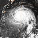
Super Typhoon Herb (Huaning)
Super Typhoon Herb was the strongest and the largest storm of 1996. Herb struck Ryūkyū IslandsRyukyu Islands
The , also known as the , is a chain of islands in the western Pacific, on the eastern limit of the East China Sea and to the southwest of the island of Kyushu in Japan. From about 1829 until the mid 20th century, they were alternately called Luchu, Loochoo, or Lewchew, akin to the Mandarin...
, Taiwan and People's Republic of China
People's Republic of China
China , officially the People's Republic of China , is the most populous country in the world, with over 1.3 billion citizens. Located in East Asia, the country covers approximately 9.6 million square kilometres...
. Maximum sustained wind
Maximum sustained wind
The maximum sustained winds associated with a tropical cyclone are a common indicator of the intensity of the storm. Within a mature tropical cyclone, they are found within the eyewall at a distance defined as the radius of maximum wind, or RMW. Unlike gusts, the value of these winds are...
s of the cyclone
Cyclone
In meteorology, a cyclone is an area of closed, circular fluid motion rotating in the same direction as the Earth. This is usually characterized by inward spiraling winds that rotate anticlockwise in the Northern Hemisphere and clockwise in the Southern Hemisphere of the Earth. Most large-scale...
reached 160 miles per hour (257.5 km/h) over the open ocean. The system led to 590 casualties and US$5 billion in damage (1996 dollars).
Typhoon Kirk (Isang)
A monsoon depression developed on July 28 over the open Pacific Ocean. It headed northwestward, slowly consolidating to become a tropical storm on the 5th. While south of Japan, Kirk drifted to the southeast and looped back to the west, strengthening to a typhoon on the 8th while looping. It continued slowly northwestward, and while curving to the northeast Kirk reached a peak of 110 mph winds. The typhoon struck southwestern Japan at that intensity on the 14th. It weakened over the country, and dissipated on the 16th over the northern Pacific. Kirk caused heavy flooding, resulting in at least 2 deaths and moderate damage.Tropical Storm Marty
The monsoon trough spawned a tropical depression over southern China on August 11. It drifted southwestward, entering the Gulf of Tonkin on the 12th. An extremely small cyclone, it reached tropical storm strength on the 13th and a peak of 60 mph on the 14th. Marty made landfall on the 14th on northern Vietnam, where it dissipated 3 days later. Though small and somewhat weak, Marty managed to cause moderate damage and flooding, amounting to the deaths of 125 with 107 people missing.Super Typhoon Sally (Maring)
On September 2, a tropical depression developed well east of the Philippines. It headed west-northwestward, reaching tropical storm strength on the 5th and typhoon strength on the 6th. On the 7th Sally rapidly intensified to a 160 mph Super Typhoon while passing just north of the PhilippinesPhilippines
The Philippines , officially known as the Republic of the Philippines , is a country in Southeast Asia in the western Pacific Ocean. To its north across the Luzon Strait lies Taiwan. West across the South China Sea sits Vietnam...
. It weakened slightly yet steadily to a 115 mph typhoon over the South China Sea, hitting the Luichow Peninsula of China
People's Republic of China
China , officially the People's Republic of China , is the most populous country in the world, with over 1.3 billion citizens. Located in East Asia, the country covers approximately 9.6 million square kilometres...
on the 9th, and dissipated the next day over the country. Sally brought heavy rain and damage to China, causing 114 casualties, 110 people missing, and economic losses estimated at $1.5 billion (1996 USD).
Typhoon Willie
An active monsoon trough that also developed Typhoons Tom (25W) and Violet (26W) spawned a tropical depression in the Gulf of Tonkin on September 16. It moved counter-clockwise around Hainan Island, becoming a tropical storm on the 17th and a typhoon on the 19th. It crossed the narrow Hainan Straight between Hainan and China, and continued west-southwestward across the Gulf of Tonkin. Willie made landfall on Vietnam on the 22nd, and dissipated the next day. The typhoon resulted in 38 fatalities from flooding.Tropical Storm Abel (Seniang)
In the Philippines, Abel killed eight people, left seven others missing and caused $4.3 million in damages.Super Typhoon Dale (Ulpiang)
A cluster of thunderstorm activity formed southeast of Guam on November 2. The system slowly organized, becoming a tropical depression on November 4. Remaining nearly stationary, the depression intensified into a tropical storm late in the day. The cyclone then turned westward, becoming a typhoon by November 7. Late in the day, Dale passed south of Guam bringing winds as high as 74 knots (145 km/h) and high seas which overtopped cliffs 30 metres (98.4 ft) high. Damage on the island totaled US$3.5 million (1996 dollars.) Continuing to intensify, Dale became a supertyphoon in the Philippine SeaPhilippine Sea
The Philippine Sea is a marginal sea east and north of the Philippines occupying an estimated surface area of 2 million mi² on the western part of the North Pacific Ocean...
on November 9. On November 10, Dale turned north, recurving east of the Philippines. On November 14, Dale accelerated east-northeast at more than 60 knots (117.6 km/h) as it became an extratropical cyclone
Extratropical cyclone
Extratropical cyclones, sometimes called mid-latitude cyclones or wave cyclones, are a group of cyclones defined as synoptic scale low pressure weather systems that occur in the middle latitudes of the Earth having neither tropical nor polar characteristics, and are connected with fronts and...
.
Tropical Storm Ernie (Toyang)
In the Philippines, Ernie killed 24 people, left 12 others missing and caused $5.1 million in damages.Tropical Storm Greg
Two active monsoon troughs that also developed Typhoon Fern and Southern Hemisphere Cyclones Ophelia, Phil, and Fergus spawned Tropical Depression 43W in the South China Sea on December 21. Due to the troughs' nature, the depression headed east-southeastward, where it strengthened into the final tropical storm of the year on the 24th; Greg. After reaching a peak of 45 knots (88.2 km/h) winds it crossed the northern part of BorneoBorneo
Borneo is the third largest island in the world and is located north of Java Island, Indonesia, at the geographic centre of Maritime Southeast Asia....
on the 25th. It continued east-southeastward until dissipation on the 27th, south of the Philippines. Greg caused extensive property damage on Borneo from torrential flooding, resulting in 127 deaths and 100 people missing.
1996 storm names
Western North Pacific tropical cyclones were named by the Joint Typhoon Warning CenterJoint Typhoon Warning Center
The Joint Typhoon Warning Center is a joint United States Navy – United States Air Force task force located at the Naval Maritime Forecast Center in Pearl Harbor, Hawaii...
. This was the first year the following names were used. The first storm of 1996 was named Ann and the final one was named Greg.
{|width="90%"
|
- Ann 02W
- Bart 04W
- Cam 05W
- Dan 06W
- Eve 07W
- Frankie 08W
- Gloria 09W
- HerbTyphoon HerbSuper Typhoon Herb was the strongest and the largest storm of 1996. Herb struck the Ryūkyū Islands, Taiwan and the People's Republic of China, causing major damage. The name Herb was used in the Western Pacific name list for the first time after the list had been revised earlier in 1996...
10W - Ian 11W
- Joy 12W
- Kirk 13W
- Lisa 14W
- Marty 16W
- Niki 18W
- Orson 19W
- Piper 20W
- Rick 22W
- Sally 23W
- Tom 25W
- Violet 26W
- Willie 27W
- Yates 28W
- Zane 29W
|
- Abel 30W
- Beth 32W
- Carlo 33W
- Dale 36W
- Ernie 37W
- Fern 42W
- Greg 43W
The 1996 Pacific typhoon season has no official bounds; it ran year-round in 1996, but most tropical cyclones tend to form in the northwestern Pacific Ocean
Pacific Ocean
The Pacific Ocean is the largest of the Earth's oceanic divisions. It extends from the Arctic in the north to the Southern Ocean in the south, bounded by Asia and Australia in the west, and the Americas in the east.At 165.2 million square kilometres in area, this largest division of the World...
between May and November. These dates conventionally delimit the period of each year when most tropical cyclones form in the northwestern Pacific Ocean
Pacific Ocean
The Pacific Ocean is the largest of the Earth's oceanic divisions. It extends from the Arctic in the north to the Southern Ocean in the south, bounded by Asia and Australia in the west, and the Americas in the east.At 165.2 million square kilometres in area, this largest division of the World...
.
The scope of this article is limited to the Pacific Ocean, north of the equator and west of the international date line
International Date Line
The International Date Line is a generally north-south imaginary line on the surface of the Earth, passing through the middle of the Pacific Ocean, that designates the place where each calendar day begins...
. Storms that form east of the date line and north of the equator are called hurricanes; see 1996 Pacific hurricane season
1996 Pacific hurricane season
The 1996 Pacific hurricane season was an event in tropical cyclone formation and the third least active Pacific hurricane season in recorded history, behind 1977 and 2010. It officially began May 15, 1996 in the eastern north Pacific and on June 1, 1996 in the central north Pacific. It ended on...
. Tropical Storms formed in the entire west pacific basin were assigned a name by the Joint Typhoon Warning Center
Joint Typhoon Warning Center
The Joint Typhoon Warning Center is a joint United States Navy – United States Air Force task force located at the Naval Maritime Forecast Center in Pearl Harbor, Hawaii...
. Tropical depressions in this basin have the "W" suffix added to their number. Tropical depressions that enter or form in the Philippine area of responsibility are assigned a name by the Philippine Atmospheric, Geophysical and Astronomical Services Administration
Philippine Atmospheric, Geophysical and Astronomical Services Administration
The Philippine Atmospheric, Geophysical and Astronomical Services Administration is a Philippine national institution dedicated to provide flood and typhoon warnings, public weather forecasts and advisories, meteorological, astronomical, climatological, and other specialized information and...
or PAGASA. This can often result in the same storm having two names.
Storms
The 1996 season was very active. Forty-four tropical cyclones formed this year, of which 33 became tropical storms. Twenty-one storms reached typhoon intensity, of which six reached super typhoon strength.Super Typhoon Eve
A Tropical Upper Tropospheric Trough spawned Tropical Depression 7W on July 10 over the open Western Pacific. It tracked generally west-northwestward, strengthening to a tropical storm on the 14th. On the 15th Eve became a typhoon, which was followed by a period of explosive deepening to a 100 mph Typhoon, with a pressure drop of 40 mb from early on the 15th to early on the 16th. An eyewall replacement cycle weakened Eve to a 95 mph typhoon, but as the outer eyewall contracted, the storm again reached wind speeds of 97 mph before hitting southern JapanJapan
Japan is an island nation in East Asia. Located in the Pacific Ocean, it lies to the east of the Sea of Japan, China, North Korea, South Korea and Russia, stretching from the Sea of Okhotsk in the north to the East China Sea and Taiwan in the south...
on the 18th. Rapidly weakening over the mountains, Eve turned eastward over the islands and the last warning was issued on the 20th. It restrengthened to a tropical storm east of Japan, and continued northeastward until dissipation on the 27th. Eve, despite being a Category 4 at landfall, caused no reported deaths and only 9 injuries.
Typhoon Frankie (Edeng)
An active monsoon trough over the Western Pacific Ocean developed 3 typhoons; Frankie, Gloria, and Herb. The first, Frankie, developed in the South China SeaSouth China Sea
The South China Sea is a marginal sea that is part of the Pacific Ocean, encompassing an area from the Singapore and Malacca Straits to the Strait of Taiwan of around...
on July 19. It tracked west-northwestward and became a tropical storm on the 21st. After crossing the island of Hainan
Hainan
Hainan is the smallest province of the People's Republic of China . Although the province comprises some two hundred islands scattered among three archipelagos off the southern coast, of its land mass is Hainan Island , from which the province takes its name...
Frankie rapidly intensified to a 100 mph typhoon over the Gulf of Tonkin
Gulf of Tonkin
The Gulf of Tonkin is an arm of the South China Sea, lying off the coast of northeastern Vietnam.-Etymology:The name Tonkin, written "東京" in Hán tự and Đông Kinh in romanised Vietnamese, means "Eastern Capital", and is the former toponym for Hanoi, the capital of Vietnam...
. It northern Vietnam
Vietnam
Vietnam – sometimes spelled Viet Nam , officially the Socialist Republic of Vietnam – is the easternmost country on the Indochina Peninsula in Southeast Asia. It is bordered by China to the north, Laos to the northwest, Cambodia to the southwest, and the South China Sea –...
on the 23rd, and dissipated 2 days later over China. 104 people were reported killed or missing in association with Frankie, and damage figures are estimated at over $200 million (1996 US Dollars).
Typhoon Gloria (Gloring)
The same monsoon trough that spawned Frankie also spawned a tropical depression on July 19 east of the PhilippinesPhilippines
The Philippines , officially known as the Republic of the Philippines , is a country in Southeast Asia in the western Pacific Ocean. To its north across the Luzon Strait lies Taiwan. West across the South China Sea sits Vietnam...
. It headed northwestward, slowly organizing into a tropical storm on the 22nd. The next day Gloria reached typhoon strength, and a day later it reached its peak of 100 mph winds. Gloria brushed the northern coast of the Philippines and turned northward to hit Taiwan
Taiwan
Taiwan , also known, especially in the past, as Formosa , is the largest island of the same-named island group of East Asia in the western Pacific Ocean and located off the southeastern coast of mainland China. The island forms over 99% of the current territory of the Republic of China following...
on the 26th. After crossing the island and the Taiwan Straight, Gloria hit China where she dissipated on the 27th. Gloria caused 23 casualties, 20 of which were in the northern Philippines. In addition, damage was estimated at $20 million (1996 USD).
Super Typhoon Herb (Huaning)
Super Typhoon Herb was the strongest and the largest storm of 1996. Herb struck Ryūkyū IslandsRyukyu Islands
The , also known as the , is a chain of islands in the western Pacific, on the eastern limit of the East China Sea and to the southwest of the island of Kyushu in Japan. From about 1829 until the mid 20th century, they were alternately called Luchu, Loochoo, or Lewchew, akin to the Mandarin...
, Taiwan and People's Republic of China
People's Republic of China
China , officially the People's Republic of China , is the most populous country in the world, with over 1.3 billion citizens. Located in East Asia, the country covers approximately 9.6 million square kilometres...
. Maximum sustained wind
Maximum sustained wind
The maximum sustained winds associated with a tropical cyclone are a common indicator of the intensity of the storm. Within a mature tropical cyclone, they are found within the eyewall at a distance defined as the radius of maximum wind, or RMW. Unlike gusts, the value of these winds are...
s of the cyclone
Cyclone
In meteorology, a cyclone is an area of closed, circular fluid motion rotating in the same direction as the Earth. This is usually characterized by inward spiraling winds that rotate anticlockwise in the Northern Hemisphere and clockwise in the Southern Hemisphere of the Earth. Most large-scale...
reached 160 miles per hour (257.5 km/h) over the open ocean. The system led to 590 casualties and US$5 billion in damage (1996 dollars).
Typhoon Kirk (Isang)
A monsoon depression developed on July 28 over the open Pacific Ocean. It headed northwestward, slowly consolidating to become a tropical storm on the 5th. While south of Japan, Kirk drifted to the southeast and looped back to the west, strengthening to a typhoon on the 8th while looping. It continued slowly northwestward, and while curving to the northeast Kirk reached a peak of 110 mph winds. The typhoon struck southwestern Japan at that intensity on the 14th. It weakened over the country, and dissipated on the 16th over the northern Pacific. Kirk caused heavy flooding, resulting in at least 2 deaths and moderate damage.Tropical Storm Marty
The monsoon trough spawned a tropical depression over southern China on August 11. It drifted southwestward, entering the Gulf of Tonkin on the 12th. An extremely small cyclone, it reached tropical storm strength on the 13th and a peak of 60 mph on the 14th. Marty made landfall on the 14th on northern Vietnam, where it dissipated 3 days later. Though small and somewhat weak, Marty managed to cause moderate damage and flooding, amounting to the deaths of 125 with 107 people missing.Super Typhoon Sally (Maring)
On September 2, a tropical depression developed well east of the Philippines. It headed west-northwestward, reaching tropical storm strength on the 5th and typhoon strength on the 6th. On the 7th Sally rapidly intensified to a 160 mph Super Typhoon while passing just north of the PhilippinesPhilippines
The Philippines , officially known as the Republic of the Philippines , is a country in Southeast Asia in the western Pacific Ocean. To its north across the Luzon Strait lies Taiwan. West across the South China Sea sits Vietnam...
. It weakened slightly yet steadily to a 115 mph typhoon over the South China Sea, hitting the Luichow Peninsula of China
People's Republic of China
China , officially the People's Republic of China , is the most populous country in the world, with over 1.3 billion citizens. Located in East Asia, the country covers approximately 9.6 million square kilometres...
on the 9th, and dissipated the next day over the country. Sally brought heavy rain and damage to China, causing 114 casualties, 110 people missing, and economic losses estimated at $1.5 billion (1996 USD).
Typhoon Willie
An active monsoon trough that also developed Typhoons Tom (25W) and Violet (26W) spawned a tropical depression in the Gulf of Tonkin on September 16. It moved counter-clockwise around Hainan Island, becoming a tropical storm on the 17th and a typhoon on the 19th. It crossed the narrow Hainan Straight between Hainan and China, and continued west-southwestward across the Gulf of Tonkin. Willie made landfall on Vietnam on the 22nd, and dissipated the next day. The typhoon resulted in 38 fatalities from flooding.Tropical Storm Abel (Seniang)
In the Philippines, Abel killed eight people, left seven others missing and caused $4.3 million in damages.Super Typhoon Dale (Ulpiang)
A cluster of thunderstorm activity formed southeast of Guam on November 2. The system slowly organized, becoming a tropical depression on November 4. Remaining nearly stationary, the depression intensified into a tropical storm late in the day. The cyclone then turned westward, becoming a typhoon by November 7. Late in the day, Dale passed south of Guam bringing winds as high as 74 knots (145 km/h) and high seas which overtopped cliffs 30 metres (98.4 ft) high. Damage on the island totaled US$3.5 million (1996 dollars.) Continuing to intensify, Dale became a supertyphoon in the Philippine SeaPhilippine Sea
The Philippine Sea is a marginal sea east and north of the Philippines occupying an estimated surface area of 2 million mi² on the western part of the North Pacific Ocean...
on November 9. On November 10, Dale turned north, recurving east of the Philippines. On November 14, Dale accelerated east-northeast at more than 60 knots (117.6 km/h) as it became an extratropical cyclone
Extratropical cyclone
Extratropical cyclones, sometimes called mid-latitude cyclones or wave cyclones, are a group of cyclones defined as synoptic scale low pressure weather systems that occur in the middle latitudes of the Earth having neither tropical nor polar characteristics, and are connected with fronts and...
.
Tropical Storm Ernie (Toyang)
In the Philippines, Ernie killed 24 people, left 12 others missing and caused $5.1 million in damages.Tropical Storm Greg
Two active monsoon troughs that also developed Typhoon Fern and Southern Hemisphere Cyclones Ophelia, Phil, and Fergus spawned Tropical Depression 43W in the South China Sea on December 21. Due to the troughs' nature, the depression headed east-southeastward, where it strengthened into the final tropical storm of the year on the 24th; Greg. After reaching a peak of 45 knots (88.2 km/h) winds it crossed the northern part of BorneoBorneo
Borneo is the third largest island in the world and is located north of Java Island, Indonesia, at the geographic centre of Maritime Southeast Asia....
on the 25th. It continued east-southeastward until dissipation on the 27th, south of the Philippines. Greg caused extensive property damage on Borneo from torrential flooding, resulting in 127 deaths and 100 people missing.
1996 storm names
Western North Pacific tropical cyclones were named by the Joint Typhoon Warning CenterJoint Typhoon Warning Center
The Joint Typhoon Warning Center is a joint United States Navy – United States Air Force task force located at the Naval Maritime Forecast Center in Pearl Harbor, Hawaii...
. This was the first year the following names were used. The first storm of 1996 was named Ann and the final one was named Greg.
{|width="90%"
|
- Ann 02W
- Bart 04W
- Cam 05W
- Dan 06W
- Eve 07W
- Frankie 08W
- Gloria 09W
- HerbTyphoon HerbSuper Typhoon Herb was the strongest and the largest storm of 1996. Herb struck the Ryūkyū Islands, Taiwan and the People's Republic of China, causing major damage. The name Herb was used in the Western Pacific name list for the first time after the list had been revised earlier in 1996...
10W - Ian 11W
- Joy 12W
- Kirk 13W
- Lisa 14W
- Marty 16W
- Niki 18W
- Orson 19W
- Piper 20W
- Rick 22W
- Sally 23W
- Tom 25W
- Violet 26W
- Willie 27W
- Yates 28W
- Zane 29W
|
- Abel 30W
- Beth 32W
- Carlo 33W
- Dale 36W
- Ernie 37W
- Fern 42W
- Greg 43W
- HannahIsaJimmyKellyLeviMarieNestorOpalPeterRosieScottTinaVictorWinnieYuleZita
|- AmberBingCassDavidEllaFritzGingerHankIvanJoanKeithLindaMortNicholeOttoPennyRexStellaToddVickiWaldoYanniZeb
|- AlexBabsChipDawnElvisFaithGilHildaIrisJacobKateLeoMaggieNeilOlgaPaulRachelSamTanyaVirgilWendyYorkZia
|}
Philippines
The Philippine Atmospheric, Geophysical and Astronomical Services AdministrationPhilippinesThe Philippines , officially known as the Republic of the Philippines , is a country in Southeast Asia in the western Pacific Ocean. To its north across the Luzon Strait lies Taiwan. West across the South China Sea sits Vietnam...
Philippine Atmospheric, Geophysical and Astronomical Services AdministrationThe Philippine Atmospheric, Geophysical and Astronomical Services Administration is a Philippine national institution dedicated to provide flood and typhoon warnings, public weather forecasts and advisories, meteorological, astronomical, climatological, and other specialized information and...
(PAGASA) uses its own naming scheme for tropical cyclones within its area of responsibility. Lists are recycled every four years. This is the same list used for the 1992 season1992 Pacific typhoon seasonOne person was killed and eight others were reported missing when the storm moved through the Philippines. Extensive damage took place in China with losses amounting to $235 million.-Typhoon Gary :At least 48 people were killed by Typhoon Gary...
.
{| width="90%"
|- Asiang 01W
- Biring 02W
- Konsing 04W
- Ditang 05W
- Edeng 08W
|- Gloring 09W
- HuaningTyphoon HerbSuper Typhoon Herb was the strongest and the largest storm of 1996. Herb struck the Ryūkyū Islands, Taiwan and the People's Republic of China, causing major damage. The name Herb was used in the Western Pacific name list for the first time after the list had been revised earlier in 1996...
10W - Isang 13W
- Lusing 18W
- Maring 23W
|- Ningning 24W
- Osang 26W
- Paring 28W
- Reming 29W
- Seniang 30W
|- Toyang 37W
- Ulpiang 36W
- Welpring (unused)Yerling (unused)Aring (unused)
|- Basiang (unused)Kayang (unused)Dorang (unused)Enang (unused)Grasing (unused)
|}
See also
- 1996 Pacific hurricane season1996 Pacific hurricane seasonThe 1996 Pacific hurricane season was an event in tropical cyclone formation and the third least active Pacific hurricane season in recorded history, behind 1977 and 2010. It officially began May 15, 1996 in the eastern north Pacific and on June 1, 1996 in the central north Pacific. It ended on...
- 1996 Atlantic hurricane season1996 Atlantic hurricane seasonThe 1996 Atlantic hurricane season was the first season since 1965 in which all tropical cyclones reached tropical storm status. It officially began on June 1, 1996, and lasted until November 30, 1996...
- 1996 North Indian cyclone season
- 1996-97 Southern Hemisphere tropical cyclone season1996-97 Southern Hemisphere tropical cyclone seasonThe 1996-97 Southern Hemisphere tropical cyclone season ran year-round from 1 July 1996 to 30 June 1997, reaching its peak mid-February to early March.1990-95 1995-96 1996-97 1997-98 1998-99-Storms:-Intense Tropical Cyclone Melanie-Bellamine:...
External links
- Japan Meteorological Agency
- Joint Typhoon Warning Center.
- China Meteorological Agency
- National Weather Service Guam
- Hong Kong Observatory
- Macau Meteorological Geophysical Services
- Korea Meteorological Agency
- Philippine Atmospheric, Geophysical and Astronomical Services Administration
- Taiwan Central Weather Bureau
- Satellite movie of 1996 Pacific typhoon season
