
1979 Pacific typhoon season
Encyclopedia
The 1979 Pacific typhoon season has no official bounds; it ran year-round in 1979, but most tropical cyclones tend to form in the northwestern Pacific Ocean between June and December. These dates conventionally delimit the period of each year when most tropical cyclones form in the northwestern Pacific Ocean.
The scope of this article is limited to the Pacific Ocean, north of the equator and west of the international date line
. Storms that form east of the date line and north of the equator are called hurricanes; see 1979 Pacific hurricane season
. Tropical Storms formed in the entire west Pacific basin were assigned a name by the Joint Typhoon Warning Center
. Tropical depressions in this basin have the "W" suffix added to their number. Tropical depressions that enter or form in the Philippine area of responsibility are assigned a name by the Philippine Atmospheric, Geophysical and Astronomical Services Administration
or PAGASA. This can often result in the same storm having two names.
, and the name was dropped from usage as new naming lists went into effect later in the year.
on July 24. It headed to the west-northwest, but upper level shear from the TUTT caused the depression to dissipate on the 27th. It turned northward then westward, where it regenerated on the 28th. Intensification became more steady, with the depression reaching storm strength on the 28th and typhoon strength on the 29th. On the 31st, Hope reached a peak of 150 mph winds, but land interaction with Taiwan
to the north weakened the storm. On August 2 95 mph Typhoon Hope hit southern China, only 10 miles east of Hong Kong. It weakened over the country while moving westward, but retained its satellite signature. Upon reaching the Bay of Bengal
on the 7th, Hope restrengthened to a tropical storm, but moved over India and dissipated on the 8th. In Guangdong Province in China, the typhoon was responsible for around 100 deaths or missing people. Twelve people died along with 260 injured in Hong Kong. This was the strongest tropical cyclone to hit Hong Kong since Typhoon Rose
in 1971.
, and neared the Chinese coast on the 23rd and 24th. Judy turned to the northeast, and brushed past South Korea as a tropical depression on the 26th, shortly before dissipating. Judy passed through Guam
and other Pacific islands, but damage was reported light there. However, the storm brought heavy rain to Korea as a tropical depression, killing 111 and more damage to an area hit by Irving just weeks before.
. The storm turned to the west, peaking at 130 mph winds on the 10th before the mid-level circulation became decoupled from the low-level circulation. Sarah weakened, and hit eastern Vietnam
on the 14th as a 60 mph tropical storm. The storm brought heavy flooding and wind, causing massive crop damage and loss of life.
ever recorded in the world. The cyclone formed on October 5, and after moving into a very favorable environment for development, quickly strengthened into Super Typhoon Tip on the 11th. On the 12th, Super Typhoon Tip continued to intensify, with winds at 190 miles per hour and central pressure at 870 millibars, the lowest barometric pressure ever recorded from a tropical cyclone
. Tip ultimately hit Japan, causing 68 deaths and moderate damage. It dissipated on October 19.
. The first storm of 1979 was named Alice and the final one was named Ben. The name Alice was retired after this season and replaced by Andy, as Alice is a female name.
{|width="90%"
|
|
The scope of this article is limited to the Pacific Ocean, north of the equator and west of the international date line
International Date Line
The International Date Line is a generally north-south imaginary line on the surface of the Earth, passing through the middle of the Pacific Ocean, that designates the place where each calendar day begins...
. Storms that form east of the date line and north of the equator are called hurricanes; see 1979 Pacific hurricane season
1979 Pacific hurricane season
The 1979 Pacific hurricane season officially started May 15, 1979 in the eastern Pacific, and June 1, 1979 in the central Pacific, and lasted until November 30, 1979. These dates conventionally delimit the period of each year when most tropical cyclones form in the northeast Pacific Ocean.With ten...
. Tropical Storms formed in the entire west Pacific basin were assigned a name by the Joint Typhoon Warning Center
Joint Typhoon Warning Center
The Joint Typhoon Warning Center is a joint United States Navy – United States Air Force task force located at the Naval Maritime Forecast Center in Pearl Harbor, Hawaii...
. Tropical depressions in this basin have the "W" suffix added to their number. Tropical depressions that enter or form in the Philippine area of responsibility are assigned a name by the Philippine Atmospheric, Geophysical and Astronomical Services Administration
Philippine Atmospheric, Geophysical and Astronomical Services Administration
The Philippine Atmospheric, Geophysical and Astronomical Services Administration is a Philippine national institution dedicated to provide flood and typhoon warnings, public weather forecasts and advisories, meteorological, astronomical, climatological, and other specialized information and...
or PAGASA. This can often result in the same storm having two names.
Storms
28 tropical depressions formed this year in the Western Pacific, of which 23 became tropical storms. 14 storms reached typhoon intensity, of which 4 reached super typhoon strength.Typhoon Alice
Very early on January 1 a tropical depression developed over the low latitudes of the open West Pacific. It tracked northwestward, reaching tropical storm strength that night and typhoon strength on the 5th. Alice turned to the west, and continued to intensify with generally favorable conditions to a peak of 130 mph winds on the 8th. Cooler, drier air to the north caused Alice to weaken to a minimal typhoon, but as the typhoon turned to the northwest it briefly re-strengthened to a 115 mph typhoon on the 11th. Upper level winds, combined with the dry air, weakened Alice for good, causing it to dissipate on the 14th after stalling for three days. Alice caused extensive damage in the Marshall IslandsMarshall Islands
The Republic of the Marshall Islands , , is a Micronesian nation of atolls and islands in the middle of the Pacific Ocean, just west of the International Date Line and just north of the Equator. As of July 2011 the population was 67,182...
, and the name was dropped from usage as new naming lists went into effect later in the year.
Super Typhoon Hope (Ising)
A tropical depression formed southeast of GuamGuam
Guam is an organized, unincorporated territory of the United States located in the western Pacific Ocean. It is one of five U.S. territories with an established civilian government. Guam is listed as one of 16 Non-Self-Governing Territories by the Special Committee on Decolonization of the United...
on July 24. It headed to the west-northwest, but upper level shear from the TUTT caused the depression to dissipate on the 27th. It turned northward then westward, where it regenerated on the 28th. Intensification became more steady, with the depression reaching storm strength on the 28th and typhoon strength on the 29th. On the 31st, Hope reached a peak of 150 mph winds, but land interaction with Taiwan
Taiwan
Taiwan , also known, especially in the past, as Formosa , is the largest island of the same-named island group of East Asia in the western Pacific Ocean and located off the southeastern coast of mainland China. The island forms over 99% of the current territory of the Republic of China following...
to the north weakened the storm. On August 2 95 mph Typhoon Hope hit southern China, only 10 miles east of Hong Kong. It weakened over the country while moving westward, but retained its satellite signature. Upon reaching the Bay of Bengal
Bay of Bengal
The Bay of Bengal , the largest bay in the world, forms the northeastern part of the Indian Ocean. It resembles a triangle in shape, and is bordered mostly by the Eastern Coast of India, southern coast of Bangladesh and Sri Lanka to the west and Burma and the Andaman and Nicobar Islands to the...
on the 7th, Hope restrengthened to a tropical storm, but moved over India and dissipated on the 8th. In Guangdong Province in China, the typhoon was responsible for around 100 deaths or missing people. Twelve people died along with 260 injured in Hong Kong. This was the strongest tropical cyclone to hit Hong Kong since Typhoon Rose
Typhoon Rose (1971)
Typhoon Rose was Category 4 typhoon that struck the northern Philippines and later eastern China in August 1971...
in 1971.
Typhoon Irving (Mameng)
The monsoon trough spawned a tropical depression on August 7 east of the Philippines. It tracked to the north then to the west. Steering currents weakened, causing the depression to loop to the north. It was able to strengthen there, reaching tropical storm status on the 11th and typhoon status on the 13th. Irving continued to the north, attaining a peak of 100 mph winds on the 15th. Its broad, loose wind field prevented it from strengthening further, and Irving weakened as it continued northward. On the 17th, Irving hit southwest South Korea as a minimal typhoon, and merged with a frontal boundary over extreme eastern Russia on the 18th. Torrential rains led to 150 fatalities, with damage at $10–$20 million (1979 USD).Super Typhoon Judy (Neneng)
A tropical disturbance organized into a tropical storm on August 15. It tracked to the northwest, becoming a tropical storm on the 17th. Judy rapidly intensified, reaching typhoon status on the 18th and a peak of 155 mph winds on the 20th. The super typhoon began to weaken as it passed south of OkinawaOkinawa Prefecture
is one of Japan's southern prefectures. It consists of hundreds of the Ryukyu Islands in a chain over long, which extends southwest from Kyūshū to Taiwan. Okinawa's capital, Naha, is located in the southern part of Okinawa Island...
, and neared the Chinese coast on the 23rd and 24th. Judy turned to the northeast, and brushed past South Korea as a tropical depression on the 26th, shortly before dissipating. Judy passed through Guam
Guam
Guam is an organized, unincorporated territory of the United States located in the western Pacific Ocean. It is one of five U.S. territories with an established civilian government. Guam is listed as one of 16 Non-Self-Governing Territories by the Special Committee on Decolonization of the United...
and other Pacific islands, but damage was reported light there. However, the storm brought heavy rain to Korea as a tropical depression, killing 111 and more damage to an area hit by Irving just weeks before.
Typhoon Sarah (Trining-Uring)
The monsoon trough spawned a tropical depression in the eastern South China Sea on September 30. It drifted eastward into Luzon, and looped to the southwest where it strengthened into a tropical storm on October 4. Sarah, with weak steering currents, drifted to the south, becoming a typhoon on the 7th before hitting Palawan IslandPalawan Island
Palawan Island is the largest island of the Palawan Province, Philippines. The northern coast of the island is along the South China Sea, while the southern coast forms part of the northern limit of the Sulu Sea. This island is very undeveloped and traditional...
. The storm turned to the west, peaking at 130 mph winds on the 10th before the mid-level circulation became decoupled from the low-level circulation. Sarah weakened, and hit eastern Vietnam
Vietnam
Vietnam – sometimes spelled Viet Nam , officially the Socialist Republic of Vietnam – is the easternmost country on the Indochina Peninsula in Southeast Asia. It is bordered by China to the north, Laos to the northwest, Cambodia to the southwest, and the South China Sea –...
on the 14th as a 60 mph tropical storm. The storm brought heavy flooding and wind, causing massive crop damage and loss of life.
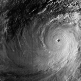
Super Typhoon Tip (Warling)
Typhoon Tip is considered to be the most intense and largest tropical cycloneTropical cyclone
A tropical cyclone is a storm system characterized by a large low-pressure center and numerous thunderstorms that produce strong winds and heavy rain. Tropical cyclones strengthen when water evaporated from the ocean is released as the saturated air rises, resulting in condensation of water vapor...
ever recorded in the world. The cyclone formed on October 5, and after moving into a very favorable environment for development, quickly strengthened into Super Typhoon Tip on the 11th. On the 12th, Super Typhoon Tip continued to intensify, with winds at 190 miles per hour and central pressure at 870 millibars, the lowest barometric pressure ever recorded from a tropical cyclone
Tropical cyclone
A tropical cyclone is a storm system characterized by a large low-pressure center and numerous thunderstorms that produce strong winds and heavy rain. Tropical cyclones strengthen when water evaporated from the ocean is released as the saturated air rises, resulting in condensation of water vapor...
. Tip ultimately hit Japan, causing 68 deaths and moderate damage. It dissipated on October 19.
1979 storm names
Western North Pacific tropical cyclones were named by the Joint Typhoon Warning CenterJoint Typhoon Warning Center
The Joint Typhoon Warning Center is a joint United States Navy – United States Air Force task force located at the Naval Maritime Forecast Center in Pearl Harbor, Hawaii...
. The first storm of 1979 was named Alice and the final one was named Ben. The name Alice was retired after this season and replaced by Andy, as Alice is a female name.
{|width="90%"
|
- Alice 1W
- Bess 2W
- Cecil 3W
- Dot 4W
- Ellis 6W
- Faye 7W
- Gordon 10W
- Hope 9W
- Irving 12W
- Judy 13W
- Ken 15W
- Lola 16W
- Mac 17W
- Nancy 18W
- Owen 19W
- Pamela 20W
- Roger 21W
- Sarah 22W
- Tip 23WTyphoon TipTyphoon Tip was the largest and most intense tropical cyclone on record. The nineteenth tropical storm and twelfth typhoon of the 1979 Pacific typhoon season, Tip developed out of a disturbance in the monsoon trough on October 4 near Pohnpei...
- Vera 24W
- Wayne 25W
|
- Abby 27W
- Ben 28W
The 1979 Pacific typhoon season has no official bounds; it ran year-round in 1979, but most tropical cyclones tend to form in the northwestern Pacific Ocean between June and December. These dates conventionally delimit the period of each year when most tropical cyclones form in the northwestern Pacific Ocean.
The scope of this article is limited to the Pacific Ocean, north of the equator and west of the international date line
International Date Line
The International Date Line is a generally north-south imaginary line on the surface of the Earth, passing through the middle of the Pacific Ocean, that designates the place where each calendar day begins...
. Storms that form east of the date line and north of the equator are called hurricanes; see 1979 Pacific hurricane season
1979 Pacific hurricane season
The 1979 Pacific hurricane season officially started May 15, 1979 in the eastern Pacific, and June 1, 1979 in the central Pacific, and lasted until November 30, 1979. These dates conventionally delimit the period of each year when most tropical cyclones form in the northeast Pacific Ocean.With ten...
. Tropical Storms formed in the entire west Pacific basin were assigned a name by the Joint Typhoon Warning Center
Joint Typhoon Warning Center
The Joint Typhoon Warning Center is a joint United States Navy – United States Air Force task force located at the Naval Maritime Forecast Center in Pearl Harbor, Hawaii...
. Tropical depressions in this basin have the "W" suffix added to their number. Tropical depressions that enter or form in the Philippine area of responsibility are assigned a name by the Philippine Atmospheric, Geophysical and Astronomical Services Administration
Philippine Atmospheric, Geophysical and Astronomical Services Administration
The Philippine Atmospheric, Geophysical and Astronomical Services Administration is a Philippine national institution dedicated to provide flood and typhoon warnings, public weather forecasts and advisories, meteorological, astronomical, climatological, and other specialized information and...
or PAGASA. This can often result in the same storm having two names.
Storms
28 tropical depressions formed this year in the Western Pacific, of which 23 became tropical storms. 14 storms reached typhoon intensity, of which 4 reached super typhoon strength.Typhoon Alice
Very early on January 1 a tropical depression developed over the low latitudes of the open West Pacific. It tracked northwestward, reaching tropical storm strength that night and typhoon strength on the 5th. Alice turned to the west, and continued to intensify with generally favorable conditions to a peak of 130 mph winds on the 8th. Cooler, drier air to the north caused Alice to weaken to a minimal typhoon, but as the typhoon turned to the northwest it briefly re-strengthened to a 115 mph typhoon on the 11th. Upper level winds, combined with the dry air, weakened Alice for good, causing it to dissipate on the 14th after stalling for three days. Alice caused extensive damage in the Marshall IslandsMarshall Islands
The Republic of the Marshall Islands , , is a Micronesian nation of atolls and islands in the middle of the Pacific Ocean, just west of the International Date Line and just north of the Equator. As of July 2011 the population was 67,182...
, and the name was dropped from usage as new naming lists went into effect later in the year.
Super Typhoon Hope (Ising)
A tropical depression formed southeast of GuamGuam
Guam is an organized, unincorporated territory of the United States located in the western Pacific Ocean. It is one of five U.S. territories with an established civilian government. Guam is listed as one of 16 Non-Self-Governing Territories by the Special Committee on Decolonization of the United...
on July 24. It headed to the west-northwest, but upper level shear from the TUTT caused the depression to dissipate on the 27th. It turned northward then westward, where it regenerated on the 28th. Intensification became more steady, with the depression reaching storm strength on the 28th and typhoon strength on the 29th. On the 31st, Hope reached a peak of 150 mph winds, but land interaction with Taiwan
Taiwan
Taiwan , also known, especially in the past, as Formosa , is the largest island of the same-named island group of East Asia in the western Pacific Ocean and located off the southeastern coast of mainland China. The island forms over 99% of the current territory of the Republic of China following...
to the north weakened the storm. On August 2 95 mph Typhoon Hope hit southern China, only 10 miles east of Hong Kong. It weakened over the country while moving westward, but retained its satellite signature. Upon reaching the Bay of Bengal
Bay of Bengal
The Bay of Bengal , the largest bay in the world, forms the northeastern part of the Indian Ocean. It resembles a triangle in shape, and is bordered mostly by the Eastern Coast of India, southern coast of Bangladesh and Sri Lanka to the west and Burma and the Andaman and Nicobar Islands to the...
on the 7th, Hope restrengthened to a tropical storm, but moved over India and dissipated on the 8th. In Guangdong Province in China, the typhoon was responsible for around 100 deaths or missing people. Twelve people died along with 260 injured in Hong Kong. This was the strongest tropical cyclone to hit Hong Kong since Typhoon Rose
Typhoon Rose (1971)
Typhoon Rose was Category 4 typhoon that struck the northern Philippines and later eastern China in August 1971...
in 1971.
Typhoon Irving (Mameng)
The monsoon trough spawned a tropical depression on August 7 east of the Philippines. It tracked to the north then to the west. Steering currents weakened, causing the depression to loop to the north. It was able to strengthen there, reaching tropical storm status on the 11th and typhoon status on the 13th. Irving continued to the north, attaining a peak of 100 mph winds on the 15th. Its broad, loose wind field prevented it from strengthening further, and Irving weakened as it continued northward. On the 17th, Irving hit southwest South Korea as a minimal typhoon, and merged with a frontal boundary over extreme eastern Russia on the 18th. Torrential rains led to 150 fatalities, with damage at $10–$20 million (1979 USD).Super Typhoon Judy (Neneng)
A tropical disturbance organized into a tropical storm on August 15. It tracked to the northwest, becoming a tropical storm on the 17th. Judy rapidly intensified, reaching typhoon status on the 18th and a peak of 155 mph winds on the 20th. The super typhoon began to weaken as it passed south of OkinawaOkinawa Prefecture
is one of Japan's southern prefectures. It consists of hundreds of the Ryukyu Islands in a chain over long, which extends southwest from Kyūshū to Taiwan. Okinawa's capital, Naha, is located in the southern part of Okinawa Island...
, and neared the Chinese coast on the 23rd and 24th. Judy turned to the northeast, and brushed past South Korea as a tropical depression on the 26th, shortly before dissipating. Judy passed through Guam
Guam
Guam is an organized, unincorporated territory of the United States located in the western Pacific Ocean. It is one of five U.S. territories with an established civilian government. Guam is listed as one of 16 Non-Self-Governing Territories by the Special Committee on Decolonization of the United...
and other Pacific islands, but damage was reported light there. However, the storm brought heavy rain to Korea as a tropical depression, killing 111 and more damage to an area hit by Irving just weeks before.
Typhoon Sarah (Trining-Uring)
The monsoon trough spawned a tropical depression in the eastern South China Sea on September 30. It drifted eastward into Luzon, and looped to the southwest where it strengthened into a tropical storm on October 4. Sarah, with weak steering currents, drifted to the south, becoming a typhoon on the 7th before hitting Palawan IslandPalawan Island
Palawan Island is the largest island of the Palawan Province, Philippines. The northern coast of the island is along the South China Sea, while the southern coast forms part of the northern limit of the Sulu Sea. This island is very undeveloped and traditional...
. The storm turned to the west, peaking at 130 mph winds on the 10th before the mid-level circulation became decoupled from the low-level circulation. Sarah weakened, and hit eastern Vietnam
Vietnam
Vietnam – sometimes spelled Viet Nam , officially the Socialist Republic of Vietnam – is the easternmost country on the Indochina Peninsula in Southeast Asia. It is bordered by China to the north, Laos to the northwest, Cambodia to the southwest, and the South China Sea –...
on the 14th as a 60 mph tropical storm. The storm brought heavy flooding and wind, causing massive crop damage and loss of life.
Super Typhoon Tip (Warling)
Typhoon Tip is considered to be the most intense and largest tropical cycloneTropical cyclone
A tropical cyclone is a storm system characterized by a large low-pressure center and numerous thunderstorms that produce strong winds and heavy rain. Tropical cyclones strengthen when water evaporated from the ocean is released as the saturated air rises, resulting in condensation of water vapor...
ever recorded in the world. The cyclone formed on October 5, and after moving into a very favorable environment for development, quickly strengthened into Super Typhoon Tip on the 11th. On the 12th, Super Typhoon Tip continued to intensify, with winds at 190 miles per hour and central pressure at 870 millibars, the lowest barometric pressure ever recorded from a tropical cyclone
Tropical cyclone
A tropical cyclone is a storm system characterized by a large low-pressure center and numerous thunderstorms that produce strong winds and heavy rain. Tropical cyclones strengthen when water evaporated from the ocean is released as the saturated air rises, resulting in condensation of water vapor...
. Tip ultimately hit Japan, causing 68 deaths and moderate damage. It dissipated on October 19.
1979 storm names
Western North Pacific tropical cyclones were named by the Joint Typhoon Warning CenterJoint Typhoon Warning Center
The Joint Typhoon Warning Center is a joint United States Navy – United States Air Force task force located at the Naval Maritime Forecast Center in Pearl Harbor, Hawaii...
. The first storm of 1979 was named Alice and the final one was named Ben. The name Alice was retired after this season and replaced by Andy, as Alice is a female name.
{|width="90%"
|
- Alice 1W
- Bess 2W
- Cecil 3W
- Dot 4W
- Ellis 6W
- Faye 7W
- Gordon 10W
- Hope 9W
- Irving 12W
- Judy 13W
- Ken 15W
- Lola 16W
- Mac 17W
- Nancy 18W
- Owen 19W
- Pamela 20W
- Roger 21W
- Sarah 22W
- Tip 23WTyphoon TipTyphoon Tip was the largest and most intense tropical cyclone on record. The nineteenth tropical storm and twelfth typhoon of the 1979 Pacific typhoon season, Tip developed out of a disturbance in the monsoon trough on October 4 near Pohnpei...
- Vera 24W
- Wayne 25W
|
- Abby 27W
- Ben 28W
- CarmenDomEllenForrestGeorgiaHerbertIdaJoeKimLexMargeNorrisOrchidPercyRuthSperryThelmaVernonWynn
|- AlexBettyCaryDinahEdFredaGeraldHollyIkeJuneKellyLynnMauryNinaOgdenPhyllisRoySusanThadVanessaWarren
|- AgnesBillClaraDoyleElsieFabianGayHazenIrmaJeffKitLeeMamieNelsonOdessaPatRubySkipTessValWinona
|}
See also
- List of Pacific typhoon seasons
- 1979 Pacific hurricane season1979 Pacific hurricane seasonThe 1979 Pacific hurricane season officially started May 15, 1979 in the eastern Pacific, and June 1, 1979 in the central Pacific, and lasted until November 30, 1979. These dates conventionally delimit the period of each year when most tropical cyclones form in the northeast Pacific Ocean.With ten...
- 1979 Atlantic hurricane season1979 Atlantic hurricane seasonThe 1979 Atlantic hurricane season was the first in which the Atlantic hurricane naming list included both male and female names. It officially began on June 1 and lasted until November 30, and there was tropical cyclone activity in every month. The dates conventionally delimit the period of each...
- Pre-1980 North Indian Ocean cyclone seasons
- Southern Hemisphere tropical cyclone seasons: 1978-79, 1979-80
External links
- Japan Meteorological Agency
- Joint Typhoon Warning Center.
- China Meteorological Agency
- National Weather Service Guam
- Hong Kong Observatory
- Macau Meteorological Geophysical Services
- Korea Meteorological Agency
- Philippine Atmospheric, Geophysical and Astronomical Services Administration
- Taiwan Central Weather Bureau
- Satellite movie of 1979 Pacific typhoon season
