
1914 Atlantic hurricane season
Encyclopedia
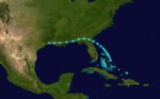
The 1914 Atlantic hurricane season was the least active Atlantic hurricane season on record, with only one known tropical storm
. Although hurricane season typically encompasses a much larger time-span, actual activity was confined to the middle of September. The only tropical cyclone of the year developed in the region of The Bahamas
on September 25 and drifted northwestward, moving inland over Florida
and Georgia
. Thorough warnings before the storm prevented any major damage. The 1914 season is one of only two that did not produce any hurricanes. Due to the lack of modern technology, including satellite imagery, information is often sparse, and an additional tropical depression may have existed in late October.
. The sole tropical storm's formation on September 14 represents the latest start to a hurricane season since officials records began in 1851.
Information on the 1914 season is chiefly based on data from the Atlantic hurricane database
(HURDAT), which underwent a thorough reanalysis of hurricanes
from 1911 through 1914 in 2005. Several changes, mostly of a minor nature, were made to the September tropical storm. Additionally, two other systems during the year were formally considered for inclusion into the hurricane database, one of which was deemed a possible tropical depression, but too weak to be classified a tropical storm. The other was assessed as a non-tropical system. The 2005 HURDAT reanalysis relied largely on historical weather maps and ship reports in place of modern technology, including satellite imagery. Since tropical cyclones in the Atlantic were not officially named until 1950, they are listed by their chronological number in older seasons.
, as indicated by weather maps from September 13. The Atlantic hurricane database initially listed the system as a tropical cyclone by September 14, although the 2005 reanalysis concluded that a closed low pressure system had not yet developed. Maps from September 15 display a weak low north of The Bahamas; however, other observations place the new cyclone further south. Decreases in air pressure
occurred throughout the islands, providing "strong indications of a disturbance". The system is officially estimated to have become a tropical depression at 0000 UTC on September 15, approximately 200 mi (321.9 km) east of Miami, Florida
. It became a tropical storm about 12 hours later and, that same evening, storm warnings were issued from the east coast of Florida to as far north as Hatteras, North Carolina
.
Gradually intensifying, the tropical cyclone drifted northwest. By September 16 the storm had deepened to 995 millibars (29.4 inHg) according to weather maps, contrasting with other data portraying a much weaker storm. It was situated south of the Georgia coast later that day. While most tropical systems in the vicinity tend to continue northward along the Eastern Seaboard
, the cyclone curved westward and moved ashore near the Florida–Georgia state border after achieving a peak intensity with maximum sustained winds of 70 mph (112.7 km/h). It progressed inland over southern Georgia as it quickly weakened, and its intensity leveled off after around 1800 UTC on September 17. It skirted the northern Gulf of Mexico
as it swerved slightly south of its westward path, and weakened to a tropical depression over southeastern Louisiana
. By early September 19, the depression had further disintegrated into an open trough
— a poorly defined, elongated area of low pressure.
The storm produced widespread rainfall in the Southeastern United States
, accompanied by gale-force winds along the coast. Ships reported severe conditions at sea. High tides were reported around St. Augustine, Florida
, washing over the South Street Causeway. Winds from the storm dispersed large amounts of dead grass from marshes in the area. No significant damage was reported, however, due to thorough warnings before the cyclone. Aside from the date of formation, the 2005 reanalysis of the storm made only minor changes to its track and intensity records. Its peak intensity, however, was raised based on a ship report of higher winds.
. A possible center of low pressure, attached to a cold front
extending southward, had formed within the larger system and moved toward the east. Another center of low pressure formed in the northwestern Caribbean on October 25 and is considered a tropical depression in contemporary research. The depression had weak winds due to the light pressure gradient in the region and, at its peak, it had a minimum central pressure of 1004 mbar (29.6 inHg). On October 26, the cold front associated with the extratropical cyclone
to the north absorbed the tropical system. The next day, the extratropical system deteriorated into an open trough. Although the tropical low was reviewed for inclusion into the hurricane database as a tropical storm in 2005, it was deemed too weak.
Tropical cyclone
A tropical cyclone is a storm system characterized by a large low-pressure center and numerous thunderstorms that produce strong winds and heavy rain. Tropical cyclones strengthen when water evaporated from the ocean is released as the saturated air rises, resulting in condensation of water vapor...
. Although hurricane season typically encompasses a much larger time-span, actual activity was confined to the middle of September. The only tropical cyclone of the year developed in the region of The Bahamas
The Bahamas
The Bahamas , officially the Commonwealth of the Bahamas, is a nation consisting of 29 islands, 661 cays, and 2,387 islets . It is located in the Atlantic Ocean north of Cuba and Hispaniola , northwest of the Turks and Caicos Islands, and southeast of the United States...
on September 25 and drifted northwestward, moving inland over Florida
Florida
Florida is a state in the southeastern United States, located on the nation's Atlantic and Gulf coasts. It is bordered to the west by the Gulf of Mexico, to the north by Alabama and Georgia and to the east by the Atlantic Ocean. With a population of 18,801,310 as measured by the 2010 census, it...
and Georgia
Georgia (U.S. state)
Georgia is a state located in the southeastern United States. It was established in 1732, the last of the original Thirteen Colonies. The state is named after King George II of Great Britain. Georgia was the fourth state to ratify the United States Constitution, on January 2, 1788...
. Thorough warnings before the storm prevented any major damage. The 1914 season is one of only two that did not produce any hurricanes. Due to the lack of modern technology, including satellite imagery, information is often sparse, and an additional tropical depression may have existed in late October.
Season summary
With only one official tropical cyclone, the 1914 season was the least active Atlantic hurricane season on record. It is one of only two Atlantic season without a storm of hurricane intensity (winds of 75 mph (120.7 km/h) or stronger), the other being the 1907 season1907 Atlantic hurricane season
The 1907 Atlantic hurricane season ran through the summer and the first half of fall in 1907. The season was a very quiet with only five tropical storms forming, with none of them reaching hurricane strength. This feat has only been accomplished one other season, the 1914 season...
. The sole tropical storm's formation on September 14 represents the latest start to a hurricane season since officials records began in 1851.
Information on the 1914 season is chiefly based on data from the Atlantic hurricane database
HURDAT
The North Atlantic hurricane database, or HURDAT, is the database for all tropical cyclones in the Atlantic Ocean, Gulf of Mexico and Caribbean Sea, since 1851.-History:...
(HURDAT), which underwent a thorough reanalysis of hurricanes
Atlantic hurricane reanalysis
Atlantic hurricane reanalysis is an ongoing project within the National Oceanic and Atmospheric Administration which seeks to correct and add new information about past Atlantic tropical cyclones...
from 1911 through 1914 in 2005. Several changes, mostly of a minor nature, were made to the September tropical storm. Additionally, two other systems during the year were formally considered for inclusion into the hurricane database, one of which was deemed a possible tropical depression, but too weak to be classified a tropical storm. The other was assessed as a non-tropical system. The 2005 HURDAT reanalysis relied largely on historical weather maps and ship reports in place of modern technology, including satellite imagery. Since tropical cyclones in the Atlantic were not officially named until 1950, they are listed by their chronological number in older seasons.
Tropical Storm One
The first and only tropical storm of the season originated in a tropical waveTropical wave
Tropical waves, easterly waves, or tropical easterly waves, also known as African easterly waves in the Atlantic region, are a type of atmospheric trough, an elongated area of relatively low air pressure, oriented north to south, which move from east to west across the tropics causing areas of...
, as indicated by weather maps from September 13. The Atlantic hurricane database initially listed the system as a tropical cyclone by September 14, although the 2005 reanalysis concluded that a closed low pressure system had not yet developed. Maps from September 15 display a weak low north of The Bahamas; however, other observations place the new cyclone further south. Decreases in air pressure
Atmospheric pressure
Atmospheric pressure is the force per unit area exerted into a surface by the weight of air above that surface in the atmosphere of Earth . In most circumstances atmospheric pressure is closely approximated by the hydrostatic pressure caused by the weight of air above the measurement point...
occurred throughout the islands, providing "strong indications of a disturbance". The system is officially estimated to have become a tropical depression at 0000 UTC on September 15, approximately 200 mi (321.9 km) east of Miami, Florida
Miami, Florida
Miami is a city located on the Atlantic coast in southeastern Florida and the county seat of Miami-Dade County, the most populous county in Florida and the eighth-most populous county in the United States with a population of 2,500,625...
. It became a tropical storm about 12 hours later and, that same evening, storm warnings were issued from the east coast of Florida to as far north as Hatteras, North Carolina
Hatteras, North Carolina
Hatteras is an unincorporated community in Dare County, North Carolina, United States, on the Outer Banks island of Hatteras. North Carolina Highway 12 passes through the community linking it to Frisco and Ocracoke . It is south of the famous Cape Hatteras and the Cape Hatteras Lighthouse in Buxton...
.
Gradually intensifying, the tropical cyclone drifted northwest. By September 16 the storm had deepened to 995 millibars (29.4 inHg) according to weather maps, contrasting with other data portraying a much weaker storm. It was situated south of the Georgia coast later that day. While most tropical systems in the vicinity tend to continue northward along the Eastern Seaboard
Eastern seaboard
An Eastern seaboard can mean any easternmost part of a continent, or its countries, states and/or cities.Eastern seaboard may also refer to:* East Coast of Australia* East Coast of the United States* Eastern Seaboard of Thailand-See also:...
, the cyclone curved westward and moved ashore near the Florida–Georgia state border after achieving a peak intensity with maximum sustained winds of 70 mph (112.7 km/h). It progressed inland over southern Georgia as it quickly weakened, and its intensity leveled off after around 1800 UTC on September 17. It skirted the northern Gulf of Mexico
Gulf of Mexico
The Gulf of Mexico is a partially landlocked ocean basin largely surrounded by the North American continent and the island of Cuba. It is bounded on the northeast, north and northwest by the Gulf Coast of the United States, on the southwest and south by Mexico, and on the southeast by Cuba. In...
as it swerved slightly south of its westward path, and weakened to a tropical depression over southeastern Louisiana
Louisiana
Louisiana is a state located in the southern region of the United States of America. Its capital is Baton Rouge and largest city is New Orleans. Louisiana is the only state in the U.S. with political subdivisions termed parishes, which are local governments equivalent to counties...
. By early September 19, the depression had further disintegrated into an open trough
Trough (meteorology)
A trough is an elongated region of relatively low atmospheric pressure, often associated with fronts.Unlike fronts, there is not a universal symbol for a trough on a weather chart. The weather charts in some countries or regions mark troughs by a line. In the United States, a trough may be marked...
— a poorly defined, elongated area of low pressure.
The storm produced widespread rainfall in the Southeastern United States
Southeastern United States
The Southeastern United States, colloquially referred to as the Southeast, is the eastern portion of the Southern United States. It is one of the most populous regions in the United States of America....
, accompanied by gale-force winds along the coast. Ships reported severe conditions at sea. High tides were reported around St. Augustine, Florida
St. Augustine, Florida
St. Augustine is a city in the northeast section of Florida and the county seat of St. Johns County, Florida, United States. Founded in 1565 by Spanish explorer and admiral Pedro Menéndez de Avilés, it is the oldest continuously occupied European-established city and port in the continental United...
, washing over the South Street Causeway. Winds from the storm dispersed large amounts of dead grass from marshes in the area. No significant damage was reported, however, due to thorough warnings before the cyclone. Aside from the date of formation, the 2005 reanalysis of the storm made only minor changes to its track and intensity records. Its peak intensity, however, was raised based on a ship report of higher winds.
Tropical depression
In addition to the September tropical storm, a possible depression that remained below tropical storm intensity developed in late October. On October 24, a broad area of low pressure was present over the western Gulf of Mexico and Caribbean SeaCaribbean Sea
The Caribbean Sea is a sea of the Atlantic Ocean located in the tropics of the Western hemisphere. It is bounded by Mexico and Central America to the west and southwest, to the north by the Greater Antilles, and to the east by the Lesser Antilles....
. A possible center of low pressure, attached to a cold front
Cold front
A cold front is defined as the leading edge of a cooler mass of air, replacing a warmer mass of air.-Development of cold front:The cooler and denser air wedges under the less-dense warmer air, lifting it...
extending southward, had formed within the larger system and moved toward the east. Another center of low pressure formed in the northwestern Caribbean on October 25 and is considered a tropical depression in contemporary research. The depression had weak winds due to the light pressure gradient in the region and, at its peak, it had a minimum central pressure of 1004 mbar (29.6 inHg). On October 26, the cold front associated with the extratropical cyclone
Extratropical cyclone
Extratropical cyclones, sometimes called mid-latitude cyclones or wave cyclones, are a group of cyclones defined as synoptic scale low pressure weather systems that occur in the middle latitudes of the Earth having neither tropical nor polar characteristics, and are connected with fronts and...
to the north absorbed the tropical system. The next day, the extratropical system deteriorated into an open trough. Although the tropical low was reviewed for inclusion into the hurricane database as a tropical storm in 2005, it was deemed too weak.
See also
- List of Florida hurricanes
- List of Atlantic hurricane seasons