
1888 North Canterbury earthquake
Encyclopedia
The 1888 North Canterbury earthquake is the name associated with a severe earthquake which occurred at 4.10 a.m on 1 September 1888 following a sequence of foreshock
s that started the previous evening, and whose epicentre was in the North Canterbury region of the South Island
of New Zealand
.
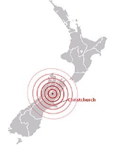
In Christchurch
, about 100 km southeast of the epicentre, shaking lasted for 40 to 50 seconds. The magnitude
of the earthquake is estimated to be in the range 7.0 - 7.3. Severe damage to farm buildings in the epicentral region was reported and the top 7.8 metres of the spire of ChristChurch Cathedral, Christchurch collapsed. It was the first earthquake observed to be associated with mainly horizontal fault displacement.
and Pacific plate
s.
The earthquake occurred on the Hope Fault
, one of the group of dextral strike-slip structures known as the Marlborough Fault System
that transfer displacement between the mainly transform
and convergent type plate boundaries
in a complex zone at the northern end of South Island. Alexander McKay, a geologist working for the geological survey, observed horizontal offsets in farm fences between 1.5 and 2.6 metres along the fault. He was the first to associate a strike-slip displacement with an earthquake.
and Hanmer
areas. Landslide
s occurred in unconsolidated sediment
and fissures up to 30 cm wide were observed.
In Christchurch
, the top 7.8 metres of the Cathedral spire fell down and minor damage, such as broken chimneys, affected many houses. Damage was greatest in the northern and northwestern suburbs, probably due to the peat
y sub-soil.
Foreshock
A foreshock is an earthquake that occurs before a larger seismic event and is related to it in both time and space. The designation of an earthquake as foreshock, mainshock or aftershock is only possible after the event....
s that started the previous evening, and whose epicentre was in the North Canterbury region of the South Island
South Island
The South Island is the larger of the two major islands of New Zealand, the other being the more populous North Island. It is bordered to the north by Cook Strait, to the west by the Tasman Sea, to the south and east by the Pacific Ocean...
of New Zealand
New Zealand
New Zealand is an island country in the south-western Pacific Ocean comprising two main landmasses and numerous smaller islands. The country is situated some east of Australia across the Tasman Sea, and roughly south of the Pacific island nations of New Caledonia, Fiji, and Tonga...
.
In Christchurch
Christchurch
Christchurch is the largest city in the South Island of New Zealand, and the country's second-largest urban area after Auckland. It lies one third of the way down the South Island's east coast, just north of Banks Peninsula which itself, since 2006, lies within the formal limits of...
, about 100 km southeast of the epicentre, shaking lasted for 40 to 50 seconds. The magnitude
Seismic scale
A seismic scale is used to calculate and compare the severity of earthquakes....
of the earthquake is estimated to be in the range 7.0 - 7.3. Severe damage to farm buildings in the epicentral region was reported and the top 7.8 metres of the spire of ChristChurch Cathedral, Christchurch collapsed. It was the first earthquake observed to be associated with mainly horizontal fault displacement.
Tectonic setting
New Zealand lies along the boundary between the AustralianIndo-Australian Plate
The Indo-Australian Plate is a major tectonic plate that includes the continent of Australia and surrounding ocean, and extends northwest to include the Indian subcontinent and adjacent waters...
and Pacific plate
Pacific Plate
The Pacific Plate is an oceanic tectonic plate that lies beneath the Pacific Ocean. At 103 million square kilometres, it is the largest tectonic plate....
s.
- In the South IslandSouth IslandThe South Island is the larger of the two major islands of New Zealand, the other being the more populous North Island. It is bordered to the north by Cook Strait, to the west by the Tasman Sea, to the south and east by the Pacific Ocean...
, most of the relative displacement between these plates is taken up along a single dextral (right lateral) strike-slip fault with a major reverse component, the Alpine FaultAlpine FaultThe Alpine Fault is a geological fault, more specifically known as a right-lateral strike-slip fault, that runs almost the entire length of New Zealand's South Island. It forms a transform boundary between the Pacific Plate and the Indo-Australian Plate. Earthquakes along the fault, and the...
.
- In the North IslandNorth IslandThe North Island is one of the two main islands of New Zealand, separated from the much less populous South Island by Cook Strait. The island is in area, making it the world's 14th-largest island...
, displacement is mainly taken up along the Kermadec-Tonga subduction zoneKermadec TrenchThe Kermadec trench is one of Earth's deepest oceanic trenches, reaching a depth of . Formed by the subduction of the Pacific Plate under the Indo-Australian Plate, it runs over a thousand kilometres parallel with and to the east of the Kermadec Ridge and island arc, from near the northeastern tip...
, although the remaining dextral strike-slip component is accommodated by the North Island Fault SystemNorth Island Fault SystemThe North Island Fault System or North Island Dextral Fault Belt is a set of southwest-northeast trending seismically-active faults in the North Island of New Zealand that carry most of the dextral strike-slip component of the oblique convergence of the Pacific Plate with the Australian Plate...
.
The earthquake occurred on the Hope Fault
Hope Fault
The Hope Fault is an active dextral strike-slip fault in the northeastern part of South Island, New Zealand. It forms part of the Marlborough Fault System, which accommodates the transfer of displacement along the oblique convergent boundary between the Indo-Australian Plate and Pacific Plate,...
, one of the group of dextral strike-slip structures known as the Marlborough Fault System
Marlborough Fault System
The Marlborough Fault System is a set of four large dextral strike-slip faults and other related structures in the northern part of South Island, New Zealand, which transfer displacement between the mainly transform plate boundary of the Alpine fault and the mainly destructive boundary of the...
that transfer displacement between the mainly transform
Transform fault
A transform fault or transform boundary, also known as conservative plate boundary since these faults neither create nor destroy lithosphere, is a type of fault whose relative motion is predominantly horizontal in either sinistral or dextral direction. Furthermore, transform faults end abruptly...
and convergent type plate boundaries
Convergent boundary
In plate tectonics, a convergent boundary, also known as a destructive plate boundary , is an actively deforming region where two tectonic plates or fragments of lithosphere move toward one another and collide...
in a complex zone at the northern end of South Island. Alexander McKay, a geologist working for the geological survey, observed horizontal offsets in farm fences between 1.5 and 2.6 metres along the fault. He was the first to associate a strike-slip displacement with an earthquake.
Damage
In the North Canterbury region many buildings were severely damaged, particularly in the Hope ValleyHope River (Canterbury)
The Hope River in Canterbury is one of three rivers by that name in the South Island of New Zealand. It is a tributary of the Waiau River.The Hope River rises at the Hope Pass in the Southern Alps, which is the main divide for the South Island...
and Hanmer
Hanmer Springs
Hanmer Springs is a small town in the Canterbury region of the South Island of New Zealand. It is located 65 kilometres southwest of Kaikoura , in the Hurunui District. The town lies on a minor road 9 kilometres north of State Highway 7, the northern route between Christchurch and the West Coast...
areas. Landslide
Landslide
A landslide or landslip is a geological phenomenon which includes a wide range of ground movement, such as rockfalls, deep failure of slopes and shallow debris flows, which can occur in offshore, coastal and onshore environments...
s occurred in unconsolidated sediment
Sediment
Sediment is naturally occurring material that is broken down by processes of weathering and erosion, and is subsequently transported by the action of fluids such as wind, water, or ice, and/or by the force of gravity acting on the particle itself....
and fissures up to 30 cm wide were observed.
In Christchurch
Christchurch
Christchurch is the largest city in the South Island of New Zealand, and the country's second-largest urban area after Auckland. It lies one third of the way down the South Island's east coast, just north of Banks Peninsula which itself, since 2006, lies within the formal limits of...
, the top 7.8 metres of the Cathedral spire fell down and minor damage, such as broken chimneys, affected many houses. Damage was greatest in the northern and northwestern suburbs, probably due to the peat
Peat
Peat is an accumulation of partially decayed vegetation matter or histosol. Peat forms in wetland bogs, moors, muskegs, pocosins, mires, and peat swamp forests. Peat is harvested as an important source of fuel in certain parts of the world...
y sub-soil.