
1883 Atlantic hurricane season
Encyclopedia
The 1883 Atlantic hurricane season ran through the summer and the first half of fall in 1883. Due to inactivity of the season, there were no storms in June, July and November. Tropical cyclones that did not approach populated areas or shipping lanes, especially if they were relatively weak and of short duration, may have been undetected. Because technologies such as satellite monitoring
were not available until the 1960s, historical data on tropical cyclones from this period are often unreliable.
, it moved to the northwest, and reached major hurricane status on the 28th. On the 29th, the hurricane peaked at 130 mi/h, but turned to the northeast where unfavorable conditions caused it to weaken. It passed south of the Canadian Maritimes, and became extratropical on August 30 to the east of Newfoundland. The extratropical storm persisted until September 2 when it lost its identity just west of Ireland
.
on September 4. It crossed Hispanola, weakening to a minimal hurricane. It restrengthened as it passed the Bahamas, and struck North Carolina
as a Category 2 hurricane
on the 11th. It dissipated over Virginia
on the 13th, after causing 156 deaths. The rains from this storm helped end a summer-long drought, though the sleek rails caused a train wreck, derailing 10 freight cars. Crop damage was little, but this was because the peanut crop had already failed from the lack of rain.
Satellite imagery
Satellite imagery consists of photographs of Earth or other planets made by means of artificial satellites.- History :The first images from space were taken on sub-orbital flights. The U.S-launched V-2 flight on October 24, 1946 took one image every 1.5 seconds...
were not available until the 1960s, historical data on tropical cyclones from this period are often unreliable.
Season summary
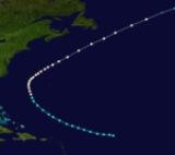
The 1883 Atlantic hurricane season was a very inactive one with activity being confined from August 18 to October 24, well inside the hurricane season. Only four storms formed, three reaching hurricane strength and two reaching major hurricane status (Category 3+). Only one storm did not affect land, which was Hurricane One.Hurricane One
The first storm of the season was first seen on August 18 in the tropical Atlantic. It moved to the west-northwest, becoming a hurricane before turning to the northeast. It moved past Newfoundland on August 26, causing 80 deaths from swells.Hurricane Two
The second storm followed a similar track to the first one. It was first identified as a hurricane on August 24 to the northeast of the Lesser Antilles. Resembling a Cape Verde-type hurricaneCape Verde-type hurricane
A Cape Verde-type hurricane is an Atlantic hurricane that develops near the Cape Verde islands, off the west coast of Africa. The average hurricane season has about two Cape Verde-type hurricanes, which are usually the largest and most intense storms of the season because they often have plenty of...
, it moved to the northwest, and reached major hurricane status on the 28th. On the 29th, the hurricane peaked at 130 mi/h, but turned to the northeast where unfavorable conditions caused it to weaken. It passed south of the Canadian Maritimes, and became extratropical on August 30 to the east of Newfoundland. The extratropical storm persisted until September 2 when it lost its identity just west of Ireland
Ireland
Ireland is an island to the northwest of continental Europe. It is the third-largest island in Europe and the twentieth-largest island on Earth...
.
Hurricane Three
A major hurricane moved through the Lesser AntillesLesser Antilles
The Lesser Antilles are a long, partly volcanic island arc in the Western Hemisphere. Most of its islands form the eastern boundary of the Caribbean Sea with the Atlantic Ocean, with the remainder located in the southern Caribbean just north of South America...
on September 4. It crossed Hispanola, weakening to a minimal hurricane. It restrengthened as it passed the Bahamas, and struck North Carolina
North Carolina
North Carolina is a state located in the southeastern United States. The state borders South Carolina and Georgia to the south, Tennessee to the west and Virginia to the north. North Carolina contains 100 counties. Its capital is Raleigh, and its largest city is Charlotte...
as a Category 2 hurricane
Saffir-Simpson Hurricane Scale
The Saffir–Simpson Hurricane Scale , or the Saffir–Simpson Hurricane Wind Scale , classifies hurricanes — Western Hemisphere tropical cyclones that exceed the intensities of tropical depressions and tropical storms — into five categories distinguished by the intensities of their sustained winds...
on the 11th. It dissipated over Virginia
Virginia
The Commonwealth of Virginia , is a U.S. state on the Atlantic Coast of the Southern United States. Virginia is nicknamed the "Old Dominion" and sometimes the "Mother of Presidents" after the eight U.S. presidents born there...
on the 13th, after causing 156 deaths. The rains from this storm helped end a summer-long drought, though the sleek rails caused a train wreck, derailing 10 freight cars. Crop damage was little, but this was because the peanut crop had already failed from the lack of rain.
Tropical Storm Four
The 4th and final tropical storm of the season formed on October 22 over the Bahamas. It moved to the north, then turned to the northeast while off the North Carolina coastline. The storm peaked at 60 mi/h on the 24th before becoming extratropical that night, but as an extratropical cyclone it strengthened to an 80 mi/h storm.See also
- List of notable tropical cyclones
- List of Atlantic hurricane seasons