
1881 Atlantic hurricane season
Encyclopedia
The 1881 Atlantic hurricane season officially began on June 1, 1881, and lasted until November 30, 1881. These dates conventionally delimit the period of each year when most tropical cyclone
s form in the Atlantic basin
. There are very few records about this season. The records that do exist show this season to be an inactive season. Only seven storms were observed.
before dissipating on the 4th.
in the middle of August, but caused no reported deaths. Signals were blown down at the harbor, and one boat was lost.
. It tracked northeastward throughout its lifetime, passing through Cuba, the Florida Keys, and the Bahamas before becoming a hurricane. It became extratropical on the 21st.
on August 22. It reached hurricane strength on the 24th, and continued northwestward until its Georgia
landfall on the 27th as a Category 2 hurricane
. It moved inland, dissipating on the 29th over northwestern Mississippi
, resulting in around 700 deaths.
. It weakened to a tropical storm over land, bringing heavy, yet beneficial, rain to the mid-Atlantic
. It moved out to sea, dissipating near Cape Cod
.
. It tracked to the northeast, reaching a peak of 70 mph (113 km/h) on the 19th while southeast of the Canadian Maritimes. It weakened over the north Atlantic, and became extratropical on the 22nd.
Tropical cyclone
A tropical cyclone is a storm system characterized by a large low-pressure center and numerous thunderstorms that produce strong winds and heavy rain. Tropical cyclones strengthen when water evaporated from the ocean is released as the saturated air rises, resulting in condensation of water vapor...
s form in the Atlantic basin
Atlantic Basin
The Atlantic Basin is the Atlantic Ocean.Atlantic Basin may also refer to:* Atlantic Basin Iron Works, an ironworks that operated in Brooklyn, New York, in the early to mid-20th century...
. There are very few records about this season. The records that do exist show this season to be an inactive season. Only seven storms were observed.
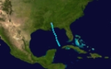
Tropical Storm One
The first storm of the season formed on August 1 to the northwest of the western tip of Cuba. It tracked northward, and hit MississippiMississippi
Mississippi is a U.S. state located in the Southern United States. Jackson is the state capital and largest city. The name of the state derives from the Mississippi River, which flows along its western boundary, whose name comes from the Ojibwe word misi-ziibi...
before dissipating on the 4th.
Tropical Storm Two
A tropical storm hit Corpus Christi, TexasCorpus Christi, Texas
Corpus Christi is a coastal city in the South Texas region of the U.S. state of Texas. The county seat of Nueces County, it also extends into Aransas, Kleberg, and San Patricio counties. The MSA population in 2008 was 416,376. The population was 305,215 at the 2010 census making it the...
in the middle of August, but caused no reported deaths. Signals were blown down at the harbor, and one boat was lost.
Hurricane Three
From August 11 to the 18th, a hurricane existed in the tropical Atlantic before turning northward and losing its identity.Hurricane Four
The fourth storm of the season developed on August 16 off the eastern coast of the Yucatán PeninsulaYucatán Peninsula
The Yucatán Peninsula, in southeastern Mexico, separates the Caribbean Sea from the Gulf of Mexico, with the northern coastline on the Yucatán Channel...
. It tracked northeastward throughout its lifetime, passing through Cuba, the Florida Keys, and the Bahamas before becoming a hurricane. It became extratropical on the 21st.
Hurricane Five
A westward moving tropical storm moved through the northeastern Lesser AntillesLesser Antilles
The Lesser Antilles are a long, partly volcanic island arc in the Western Hemisphere. Most of its islands form the eastern boundary of the Caribbean Sea with the Atlantic Ocean, with the remainder located in the southern Caribbean just north of South America...
on August 22. It reached hurricane strength on the 24th, and continued northwestward until its Georgia
Georgia (U.S. state)
Georgia is a state located in the southeastern United States. It was established in 1732, the last of the original Thirteen Colonies. The state is named after King George II of Great Britain. Georgia was the fourth state to ratify the United States Constitution, on January 2, 1788...
landfall on the 27th as a Category 2 hurricane
Saffir-Simpson Hurricane Scale
The Saffir–Simpson Hurricane Scale , or the Saffir–Simpson Hurricane Wind Scale , classifies hurricanes — Western Hemisphere tropical cyclones that exceed the intensities of tropical depressions and tropical storms — into five categories distinguished by the intensities of their sustained winds...
. It moved inland, dissipating on the 29th over northwestern Mississippi
Mississippi
Mississippi is a U.S. state located in the Southern United States. Jackson is the state capital and largest city. The name of the state derives from the Mississippi River, which flows along its western boundary, whose name comes from the Ojibwe word misi-ziibi...
, resulting in around 700 deaths.
Hurricane Six
A hurricane existed north of Hispanola on September 7. It moved northwestward, reaching a peak of 100 mph prior to hitting southern North CarolinaNorth Carolina
North Carolina is a state located in the southeastern United States. The state borders South Carolina and Georgia to the south, Tennessee to the west and Virginia to the north. North Carolina contains 100 counties. Its capital is Raleigh, and its largest city is Charlotte...
. It weakened to a tropical storm over land, bringing heavy, yet beneficial, rain to the mid-Atlantic
Mid-Atlantic States
The Mid-Atlantic states, also called middle Atlantic states or simply the mid Atlantic, form a region of the United States generally located between New England and the South...
. It moved out to sea, dissipating near Cape Cod
Cape Cod
Cape Cod, often referred to locally as simply the Cape, is a cape in the easternmost portion of the state of Massachusetts, in the Northeastern United States...
.
Tropical Storm Seven
The final storm of the season was first seen on September 18 to the northwest of BermudaBermuda
Bermuda is a British overseas territory in the North Atlantic Ocean. Located off the east coast of the United States, its nearest landmass is Cape Hatteras, North Carolina, about to the west-northwest. It is about south of Halifax, Nova Scotia, Canada, and northeast of Miami, Florida...
. It tracked to the northeast, reaching a peak of 70 mph (113 km/h) on the 19th while southeast of the Canadian Maritimes. It weakened over the north Atlantic, and became extratropical on the 22nd.
See also
- List of tropical cyclones
- List of Atlantic hurricane seasons