

Žitná-Radiša
Encyclopedia
Village
A village is a clustered human settlement or community, larger than a hamlet with the population ranging from a few hundred to a few thousand , Though often located in rural areas, the term urban village is also applied to certain urban neighbourhoods, such as the West Village in Manhattan, New...
and municipality
Municipality
A municipality is essentially an urban administrative division having corporate status and usually powers of self-government. It can also be used to mean the governing body of a municipality. A municipality is a general-purpose administrative subdivision, as opposed to a special-purpose district...
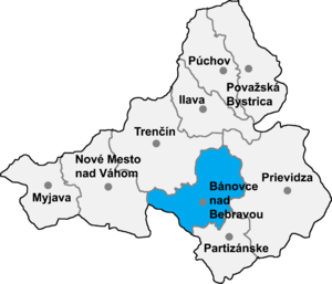
in Bánovce nad Bebravou District
Bánovce nad Bebravou District
Bánovce nad Bebravou District is adistrict inthe Trenčín Region of western Slovakia.Until 1918, the district was mostly part of theHungarian countyof Trenčín, except for a small...
in the Trenčín Region
Trencín Region
The Trenčín Region is one of the eight Slovak administrative regions. It consists of 9 districts .-Geography:It is located in the north-western Slovakia, has an area of 4,502 km² and a population of 600,386 . The Danubian Lowland reaches the region to Nové Mesto nad Váhom and Partizánske areas...
of north-western Slovakia
Slovakia
The Slovak Republic is a landlocked state in Central Europe. It has a population of over five million and an area of about . Slovakia is bordered by the Czech Republic and Austria to the west, Poland to the north, Ukraine to the east and Hungary to the south...
.
Geography
The municipalityMunicipality
A municipality is essentially an urban administrative division having corporate status and usually powers of self-government. It can also be used to mean the governing body of a municipality. A municipality is a general-purpose administrative subdivision, as opposed to a special-purpose district...
lies at an elevation
Elevation
The elevation of a geographic location is its height above a fixed reference point, most commonly a reference geoid, a mathematical model of the Earth's sea level as an equipotential gravitational surface ....
of 275 meters (902 ft) and covers an area of 17.769 km² (6.861 mi²). It has a population of about 458 people.
External links
- http://www.statistics.sk/mosmis/eng/run.html